 |
|
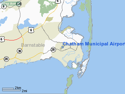
Chatham Municipal Airport |
| Chatham Municipal Airport |
| IATA: none – ICAO: KCQX – FAA LID: CQX |
| Summary |
| Airport type |
Public |
| Owner |
Town of Chatham |
| Location |
Chatham, Massachusetts |
| Elevation AMSL |
68 ft / 21 m |
| Coordinates |
41°41′18″N 069°59′22″W / 41.68833°N 69.98944°W / 41.68833; -69.98944 |
| Runways |
| Direction |
Length |
Surface |
| ft |
m |
| 6/24 |
3,001 |
915 |
Asphalt |
| Statistics (2006) |
| Aircraft operations |
25,530 |
| Based aircraft |
47 |
| Source: Federal Aviation Administration |
Chatham Municipal Airport (ICAO: KCQX, FAA LID: CQX) is a public airport located two miles (3 km) northwest of the central business district of Chatham, a town in Barnstable County, Massachusetts, United States. The airport is owned by the Town of Chatham. It has a full service FBO (Cape Cod Flying Circus) and maintenance facility in their main building(Stick N Rudder Aero Mantinence). The flight school and sightseeing is operated by Cape Aerial Tours. There is also a restaurant Hanger B, a small eatery upstairs, serving breakfast and lunch.
Facilities and aircraft
Chatham Municipal Airport covers an area of 105 acres (42 ha) which contains one paved runway (6/24) measuring 3,001 x 100 ft (915 x 30 m).
For 12-month period ending January 1, 2007, the airport had 25,530 aircraft operations, an average of 69 per day: 99% general aviation, 1% air taxi and <1% military. There are 47 aircraft based at this airport: 85% single engine, 11% multi-engine and 4% helicopters.
The above content comes from Wikipedia and is published under free licenses – click here to read more.
|
Location & QuickFacts
|
FAA
Information Effective: |
2008-09-25 |
|
Airport Identifier: |
CQX |
|
Airport Status: |
Operational |
|
Longitude/Latitude: |
069-59-22.2870W/41-41-18.2410N
-69.989524/41.688400 (Estimated) |
|
Elevation: |
68 ft / 20.73 m (Surveyed) |
|
Land: |
105 acres |
|
From
nearest city: |
2 nautical miles NW of Chatham, MA |
|
Location: |
Barnstable County, MA |
|
Magnetic Variation: |
16W (1990) |
Owner & Manager
|
Ownership: |
Publicly owned |
|
Owner: |
Town Of Chatham |
|
Address: |
Main Street
Chatham, MA 02633 |
|
Phone number: |
508-945-5100 |
|
Manager: |
Lonnie Pickett |
|
Address: |
Chatham Municipal Airport
Chatham, MA 02633 |
|
Phone number: |
508-945-9000 |
Airport Operations and
Facilities
|
Airport Use: |
Open to public |
|
Wind
indicator: |
Yes |
|
Segmented Circle: |
No |
|
Control Tower: |
No |
|
Lighting Schedule: |
DUSK-DAWN
ACTVT MIRL RY 06/24 - 122.95. |
|
Beacon Color: |
Clear-Green (lighted land airport) |
|
Landing fee charge: |
No |
|
Sectional chart: |
New York |
|
Region: |
ANE - New England |
|
Boundary ARTCC: |
ZBW - Boston |
|
Tie-in FSS: |
BDR - Bridgeport |
|
FSS
on Airport: |
No |
|
FSS
Toll Free: |
1-800-WX-BRIEF |
|
NOTAMs Facility: |
CQX (NOTAM-d service avaliable) |
|
Federal Agreements: |
NGY |
Airport Communications
|
CTAF: |
122.800 |
|
Unicom: |
122.800 |
Airport Services
|
Fuel
available: |
100LL |
|
Airframe Repair: |
MAJOR |
|
Power Plant Repair: |
MAJOR |
|
Bottled Oxygen: |
NONE |
|
Bulk
Oxygen: |
NONE |
|
Runway Information
Runway 06/24
|
Dimension: |
3001 x 100 ft / 914.7 x 30.5 m |
|
Surface: |
ASPH, Good Condition |
|
Weight
Limit: |
Single wheel: 30000 lbs. |
|
Edge
Lights: |
Medium |
|
|
Runway 06
|
Runway 24
|
|
Longitude: |
069-59-36.0040W |
069-59-08.5680W |
|
Latitude: |
41-41-07.5620N |
41-41-28.9190N |
|
Elevation: |
54.00 ft |
67.00 ft |
|
Alignment: |
44 |
127 |
|
Traffic Pattern: |
Left |
Left |
|
Markings: |
Basic, Fair Condition |
Basic, Fair Condition |
|
VASI: |
|
2-light PAPI on right side |
|
Obstruction: |
42 ft trees, 800.0 ft from runway, 150 ft right of centerline, 14:1
slope to clear |
232 ft tank, 3100.0 ft from runway, 75 ft left of centerline, 12:1
slope to clear |
|
Radio Navigation Aids
|
ID |
Type |
Name |
Ch |
Freq |
Var |
Dist |
|
CQX |
NDB |
Nauset |
|
279.00 |
16W |
0.2 nm |
|
PVC |
NDB |
Provincetown |
|
389.00 |
16W |
25.2 nm |
|
TUK |
NDB |
Nantucket |
|
194.00 |
15W |
26.6 nm |
|
FFF |
NDB |
Plymouth |
|
257.00 |
16W |
37.7 nm |
|
IMR |
NDB |
Marshfield |
|
368.00 |
16W |
39.3 nm |
|
TAN |
NDB |
Taunton |
|
227.00 |
16W |
47.4 nm |
|
FMH |
TACAN |
Otis |
105X |
|
15W |
23.6 nm |
|
LFV |
VOR/DME |
Marconi |
094X |
114.70 |
16W |
19.9 nm |
|
ACK |
VOR/DME |
Nantucket |
109X |
116.20 |
15W |
24.5 nm |
|
MVY |
VOR/DME |
Marthas Vineyard |
092X |
114.50 |
15W |
33.1 nm |
Remarks
-
< OTIS
VCNTY TFC HELICOPTER HEAVY & JET MILITARY HI-SPEED OF AWARE>
-
BIRDS
PRIMARILY GULLS FREQUENTLY ON OR INVOF ARPT.
-
RCMD MIN
ALT OF 2000' AGL FM NORTHEAST TO SOUTHEAST OF ARPT OVER NATIONAL SEASHORE
.
-
WATER
LANDING AREA CLSD PERMLY.
-
ESTAB PRIOR TO 1959.
Based Aircraft
|
Aircraft
based on field: |
36 |
|
Single
Engine Airplanes: |
30 |
|
Multi
Engine Airplanes: |
5 |
|
Helicopters: |
1 |
Operational Statistics
Time
Period: 2007-02-02 - 2008-02-01
|
Aircraft
Operations: |
70/Day |
|
Air Taxi: |
0.8% |
|
General
Aviation Local: |
59.9% |
|
General
Aviation Itinerant: |
39.2% |
|
Military: |
0.1% |
Chatham Municipal Airport
Address:
Barnstable County, MA
Tel:
508-945-5100,
508-945-9000
Images
and information placed above are from
http://www.airport-data.com/airport/CQX/
We
thank them for the data!
| General Info |
| Country |
United States |
| State |
MASSACHUSETTS |
| FAA ID |
CQX |
| Latitude |
41-41-18.241N |
| Longitude |
069-59-22.287W |
| Elevation |
68 feet |
| Near City |
CHATHAM |
We don't guarantee the information is fresh and accurate. The data may
be wrong or outdated.
For more up-to-date information please refer to other sources.
|
|


