 |
|
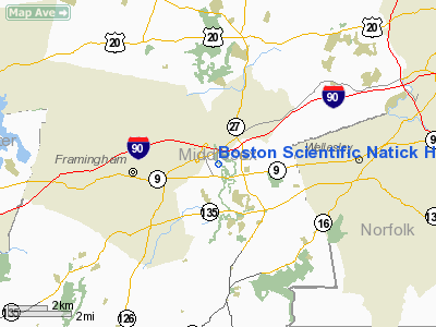
Boston Scientific Natick Heliport |
|
Location & QuickFacts
|
FAA
Information Effective: |
2008-09-25 |
|
Airport Identifier: |
MA56 |
|
Airport Status: |
Operational |
|
Longitude/Latitude: |
071-22-31.0000W/42-18-18.0000N
-71.375278/42.305000 (Estimated) |
|
Elevation: |
167 ft / 50.90 m (Estimated) |
|
Land: |
0 acres |
|
From
nearest city: |
2 nautical miles NW of Natick, MA |
|
Location: |
Middlesex County, MA |
|
Magnetic Variation: |
16W (2000) |
Owner & Manager
|
Ownership: |
Privately owned |
|
Owner: |
Boston Scientific Corp |
|
Address: |
One Boston Scientific Place
Natick, MA 01760 |
|
Phone number: |
508-650-8373 |
|
Manager: |
James Blacquier |
|
Address: |
55 Fairbanks Blvd
Marlboro, MA 01752 |
|
Phone number: |
508-650-8373 |
Airport Operations and Facilities
|
Airport Use: |
Private |
|
Wind
indicator: |
Yes |
|
Segmented Circle: |
No |
|
Control Tower: |
No |
|
Lighting Schedule: |
RDO-CTL
ACTVT PERIMETER LGTS - 123.05. |
|
Sectional chart: |
New York |
|
Region: |
ANE - New England |
|
Boundary ARTCC: |
ZBW - Boston |
|
Tie-in FSS: |
BDR - Bridgeport |
|
FSS
Toll Free: |
1-800-WX-BRIEF |
|
Runway Information
Helipad H1
|
Dimension: |
40 x 40 ft / 12.2 x 12.2 m |
|
Surface: |
CONC, |
|
|
Runway H1
|
Runway
|
|
Traffic Pattern: |
Left |
Left |
|
Radio Navigation Aids
|
ID |
Type |
Name |
Ch |
Freq |
Var |
Dist |
|
ORW |
FAN MARKER |
Canton |
|
|
15W |
13.2 nm |
|
BVY |
FAN MARKER |
Beverly |
|
|
|
26.5 nm |
|
SKR |
NDB |
Shaker Hill |
|
251.00 |
16W |
12.6 nm |
|
IHM |
NDB |
Mansfield |
|
220.00 |
16W |
19.8 nm |
|
LQ |
NDB |
Lyndy |
|
382.00 |
16W |
20.3 nm |
|
FIT |
NDB |
Fitchburg |
|
365.00 |
15W |
22.5 nm |
|
SFZ |
NDB |
Central |
|
241.00 |
15W |
23.7 nm |
|
TOF |
NDB |
Topsfield |
|
269.00 |
16W |
26.5 nm |
|
TAN |
NDB |
Taunton |
|
227.00 |
16W |
30.3 nm |
|
AS |
NDB |
Chern |
|
359.00 |
16W |
32.7 nm |
|
IMR |
NDB |
Marshfield |
|
368.00 |
16W |
33.6 nm |
|
DRY |
NDB |
Derry |
|
338.00 |
16W |
34.0 nm |
|
FFF |
NDB |
Plymouth |
|
257.00 |
16W |
37.5 nm |
|
ORE |
NDB |
Orange |
|
205.00 |
15W |
43.4 nm |
|
CO |
NDB |
Epsom |
|
216.00 |
16W |
49.0 nm |
|
NZW |
TACAN |
South Weymouth |
061X |
|
15W |
21.6 nm |
|
LWM |
VOR/DME |
Lawrence |
072X |
112.50 |
15W |
29.0 nm |
|
PUT |
VOR/DME |
Putnam |
121X |
117.40 |
14W |
29.6 nm |
|
MHT |
VOR/DME |
Manchester |
091X |
114.40 |
15W |
33.9 nm |
|
BOS |
VORTAC |
Boston |
074X |
112.70 |
16W |
17.4 nm |
|
GDM |
VORTAC |
Gardner |
043X |
110.60 |
14W |
33.6 nm |
|
PVD |
VORTAC |
Providence |
103X |
115.60 |
14W |
35.0 nm |
|
BED |
VOT |
Laurence G Hanscom Fld |
|
110.00 |
|
10.5 nm |
|
BOS |
VOT |
Boston Logan Intl |
|
111.00 |
|
16.3 nm |
|
ORH |
VOT |
Worcester |
|
108.20 |
|
22.1 nm |
|
PVD |
VOT |
Providence |
|
108.20 |
|
35.0 nm |
Remarks
-
PRVDD
VFR OPNS, INGRESS & EGRESS USE THE RR TRACKS EAST OF MASSACHUSETTS
TURNPIKE NORTH OF HELIPAD; USERS ARE NOTIFIED & COMPLY W/CONDITIONS.
Boston Scientific Natick Heliport
Address:
Middlesex County, MA
Tel:
508-650-8373
Images
and information placed above are from
http://www.airport-data.com/airport/MA56/
We
thank them for the data!
|
General Info |
| Country |
United
States |
| State |
IOWA
|
| FAA ID |
CID
|
| Latitude |
41-53-04.518N |
|
Longitude |
091-42-39.140W |
|
Elevation |
864 feet
|
| Near
City |
CEDAR
RAPIDS |
We don't guarantee the information is fresh and accurate. The data may
be wrong or outdated.
For more up-to-date information please refer to other sources.
|
|


