|
 |
|
||||
|
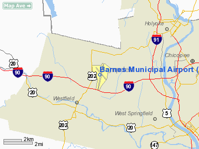
Barnes Municipal Airport (IATA: BAF, ICAO: KBAF, FAA LID: BAF), also known as Westfield-Barnes Airport, is a tower-controlled joint civil-military public airport located three miles (5 km) north of the central business district of Westfield, a city in Hampden County, Massachusetts, United States. This airport is owned by City of Westfield. The airport is also northwest of the larger city of Springfield and the FAA lists the location as "Westfield/Springfield". Barnes is one of Massachusetts' largest airports with a strong flight training, general aviation, and military presence. HistoryJuly 13, 1914 can be the date where aviation in Westfield is traced back to. Jack McGee of Pawtucket, Rhode Island flew a Wright biplane over Westfield and the flight originated on a strip of land near Southampton Road and the Holyoke Rail Bridge. McGee was hired by local merchants to drop tickets from his airplane which could have been claimed for prizes. Following the entry of the United States into World War I, however, the expansive plain was heavily utilized by the federal government in August-September 1917 as Camp Bartlett, a mobilization and training camp for the 103rd and 104th Infantry Regiments of the 26th "Yankee" Division, prior to deployment in France. In 1923, citizens of Westfield, and nearby Holyoke set out to build an airport. A group of influential local businessmen was charged to convince the owner of the land where the airport is now, Vincent E. Barnes, to sell his land to the City of Westfield for an airport. Barnes agreed to give up his land and he didn't ask for a mere penny from the city or the businessmen. The 27-acre (110,000 m) plot was named Westfield Aviation Field and was dedicated on October 12, 1923. However as the field gained in popularity, Vincent Barnes leased the city another 27-acre (110,000 m) plot, with only a fee of $1 per year starting in 1927. In 1936, Mrs. Barnes and her daughter Saddie Knox donated an additional 297 acres (1.2 km²) to the city of Westfield. Shortly thereafter, the City Council voted to name the airport after the family who made it possible, Barnes. Between 1939 and 1940, the administration building, hangar, and the beacon light were built with grant money totaling near $90,000. Soon, a passenger service was started out of the airport. on October 28, 1937, a 10 passenger Stinson Trimotor aircraft began flying between Westfield and Newark, New Jersey. Later American Airlines began to operate out of Westfield using DC-3 aircraft in 1938. During World War II young men from the University of Massachusetts at Amherst received flight training at the airport before being shipped off to various war sites. Soon after, the Air National Guard was formed and its presence was soon established at Barnes. The Air National Guard first began using P-47 Thunderbolt aircraft, but soon began using the P-51 Mustang after Runway 2/20 was extended from 5,000 to 7,000 feet (2,100 m). Barnes received jet aircraft when the Air National Guard began to operate F-94 Starfire aircraft. Up until September 2007, the 131st Fighter Squadron (131 FS), 104th Fighter Wing (104 FW) of the Massachusetts Air National Guard at Westfield operated the A-10 Thunderbolt II. There were 25 A-10's based at Barnes until they were realigned through the DoD's Base Realignment and Closure of 2005. As a result of BRAC, the 104th changed its mission from Close Air Support to Air Superiority and its A-10 aircraft were redistributed to other fighter units. The 104 FW has now received 15 F-15 Eagles from the former 102nd Fighter Wing, now 102nd Intelligence Wing of the Massachusetts Air National Guard at Otis ANGB, with the 104 FW continuing to remain operationally-gained by the Air Combat Command (ACC). Over the last 50 years, the airport has added numerous infrastructure improvements including another runway, 15/33 which has a length of 5,000 feet (1,500 m). Also a VORTAC and an ILS system have been put in making the airport more attractive for General Aviation pilots as well. Most importantly in 1974, the airport's Air Traffic Control Tower was opened easing traffic congestion at the airport. FacilitiesBarnes Municipal Airport covers an area of 1,200 acres (5 km²) which contains two paved runways: 2/20 measuring 9,000 x 150 ft (2,743 x 46 m) and 15/33 measuring 5,000 x 100 ft (1,524 x 30 m). The airport has recently opened a new administration and terminal which replaced an aging terminal building that used to house the original control tower. The airport is also the site of a major Massachusetts Air National Guard fighter jet wing and support installation. AircraftFor 12-month period ending December 31, 2005, the airport had 60,855 aircraft operations, an average of 166 per day: 86% general aviation, 13% military, 1% air taxi and <1% scheduled commercial. There are 149 aircraft based at this airport: 71% single engine, 7% multi-engine, 5% jet aircraft and 17% military. Fixed Base OperatorsBarnes Municipal Airport has two fixed base operators (FBOs). Five Star Jet Center, the original established FBO at Barnes, offers services such as fuel, maintenance, hangar storage, catering, and transportation, to charter and international business flights. It also owns two Learjet 31A Corporate Jets. They recently switched to Air BP, and now have the newest fueling equipment at the airport. AirFlyte, Inc. is an FBO that also operates in the new admin building which includes a conference room, weather facilities, and comprehensive pilot services. They sell Shell fuel and provide typical FBO services such as tie-downs. Flight SchoolsBarnes Municipal Airport has two FAA-approved flight schools. The largest program is an official part 141 flight school named Five Star Flight Academy, (a separate business from Five Star Jet Center mentioned above). The flight school offers instruction in 3 Cessna 172's, a Cessna 150, a Cessna 172 Cutlass RG and a Piper Seneca. It is run by a current DHL Airbus A300 pilot and a Springfield attorney. In addition, AD-UP Aviation operates a part 61 flight school out of the new terminal building. The school is run by a Master Certified Flight instructor, one of fewer than a dozen in Massachusetts. Instruction is given in high-wing, tail-dragger, and spin training. AD-UP Aviation also offers aerial advertising by towing banners. Restaurant & BarThe former Flight Deck restaurant was replaced with The Runway when the new terminal opened. The Runway is operated by the owner of the now-closed B'Sharas Restaurant of West Springfield. It features a full menu and bar. The Runway, like most of the terminal, is open to the public. Parking is free. Restaurants and DiningThe Runway Restaurant and Lounge is a restaurant overlooking the airport, containing an outdoor observation deck. Special events at the Runway have planned to coordinate with airshows and other important airport activities. Website The Runway is owned and operated by B'shara's. The above content comes from Wikipedia and is published under free licenses – click here to read more.
Runway Information Runway 02/20
Runway 15/33
Radio Navigation Aids
Remarks
Based Aircraft
Operational Statistics Time Period: 2007-06-02 - 2008-05-31
Barnes Municipal Airport Address: Hampden County, MA Tel: 413-572-6200, 413-572-6275 Images
and information placed above are from We thank them for the data!
We don't guarantee the information is fresh and accurate. The data may
be wrong or outdated.
|
||||||||||||||||||||||||||||||||||||||||||||||||||||||||||||||||||||||||||||||||||||||||||||||||||||||||||||||||||||||||||||||||||||||||||||||||||||||||||||||||||||||||||||||||||||||||||||||||||||||||||||||||||||||||||||||||||||||||||||||||||||||||||||||||||||||||||||||||||||||||||||||||||||||||||||||||||||||||||||||||||||||||||||||||||||||||||||||||||||||||||||||||||||||||||||||||||||||||||||||||||||||||||||||||||||||||||||||||||||||||||||||||||||||||||||||||||||||||||||||||||||||||||||||||||||||||||||||||||

 |
|
Copyright 2004-2026 © by Airports-Worldwide.com, Vyshenskoho st. 36, Lviv 79010, Ukraine Legal Disclaimer |