 |
|
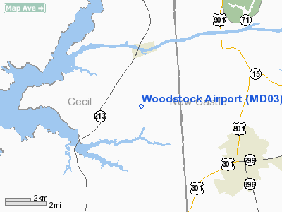
Location & QuickFacts
| FAA Information Effective: | 2008-09-25 |
| Airport Identifier: | MD03 |
| Airport Status: | Closed Permanently |
| Longitude/Latitude: | 075-48-39.7720W/39-29-18.4060N
-75.811048/39.488446 (Estimated) |
| Elevation: | 81 ft / 24.69 m (Estimated) |
| Land: | 0 acres |
| From nearest city: | 2 nautical miles S of Chesapeake City, MD |
| Location: | Cecil County, MD |
| Magnetic Variation: | 11W (1985) |
Owner & Manager
| Ownership: | Privately owned |
| Address: |
|
| Manager: | Caroline Dup Prickett |
| Address: | Summit Aviation
Middletown, DE 19709 |
| Phone number: | 302-834-5400 |
Airport Operations and Facilities
| Airport Use: | Private |
| Wind indicator: | Yes |
| Segmented Circle: | No |
| Control Tower: | No |
| Landing fee charge: | No |
| Sectional chart: | Washington |
| Region: | AEA - Eastern |
| Boundary ARTCC: | ZDC - Washington |
| Tie-in FSS: | DCA - Leesburg |
| FSS on Airport: | No |
| FSS Toll Free: | 1-800-WX-BRIEF |
Airport Services
| Airframe Repair: | NONE |
| Power Plant Repair: | NONE |
Runway Information
Runway 05/23
| Dimension: | 3700 x 150 ft / 1127.8 x 45.7 m |
| Surface: | TURF, |
| |
Runway 05 |
Runway 23 |
| Traffic Pattern: | Left | Left |
|
Radio Navigation Aids
| ID |
Type |
Name |
Ch |
Freq |
Var |
Dist |
| APG | NDB | Aberdeen | | 349.00 | 11W | 14.0 nm |
| MTN | NDB | Martin | | 342.00 | 11W | 28.8 nm |
| RNB | NDB | Rainbow | | 363.00 | 11W | 31.7 nm |
| IUB | NDB | Institute | | 404.00 | 08W | 39.7 nm |
| ESN | NDB | Easton | | 212.00 | 10W | 42.8 nm |
| ING | NDB | Ambler | | 275.00 | 11W | 45.4 nm |
| FND | NDB | Ellicott | | 371.00 | 11W | 46.5 nm |
| DOV | TACAN | Dover | 037X | | 09W | 26.7 nm |
| MTN | TACAN | Martin | 068X | | 11W | 29.4 nm |
| PPM | VOR/DME | Phillips | 021X | 108.40 | 09W | 16.8 nm |
| ATR | VOR/DME | Waterloo | 073X | 112.60 | 09W | 49.5 nm |
| DQO | VORTAC | Dupont | 087X | 114.00 | 10W | 14.8 nm |
| ENO | VORTAC | Smyrna | 051X | 111.40 | 09W | 20.6 nm |
| OOD | VORTAC | Woodstown | 075X | 112.80 | 10W | 25.2 nm |
| MXE | VORTAC | Modena | 079X | 113.20 | 09W | 26.6 nm |
| VCN | VORTAC | Cedar Lake | 099X | 115.20 | 10W | 39.2 nm |
| BAL | VORTAC | Baltimore | 098X | 115.10 | 11W | 43.9 nm |
| LRP | VORTAC | Lancaster | 120X | 117.30 | 09W | 44.0 nm |
| PTW | VORTAC | Pottstown | 112X | 116.50 | 09W | 45.6 nm |
| PHL | VOT | Philadelphia Intl | | 109.80 | | 34.8 nm |
Remarks
- (ARPT STATUS) ARPT CLSD PERMLY.
Images and information placed above are from
http://www.airport-data.com/airport/MD03/
We thank them for the data!
| General Info
|
| Country |
United States
|
| State |
MARYLAND
|
| FAA ID |
MD03
|
| Latitude |
39-29-18.406N
|
| Longitude |
075-48-39.772W
|
| Elevation |
81 feet
|
| Near City |
CHESAPEAKE CITY
|
We don't guarantee the information is fresh and accurate. The data may
be wrong or outdated.
For more up-to-date information please refer to other sources.
|
|


