 |
|
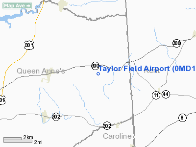
Location & QuickFacts
| FAA Information Effective: | 2008-09-25 |
| Airport Identifier: | 0MD1 |
| Airport Status: | Operational |
| Longitude/Latitude: | 075-47-33.7620W/39-11-14.4000N
-75.792712/39.187333 (Estimated) |
| Elevation: | 75 ft / 22.86 m (Estimated) |
| Land: | 3 acres |
| From nearest city: | 3 nautical miles E of Sudlersville, MD |
| Location: | Washington County, MD |
| Magnetic Variation: | 11W (1990) |
Owner & Manager
| Ownership: | Privately owned |
| Owner: | John S. & Annabelle E. Taylor
& JOHN PANIERE. |
| Address: | 1913 Peters Corner Road
Marydel, MD 21649-9606 |
| Phone number: | 301-438-3178 |
| Manager: | John S. Taylor |
| Address: | 1913 Peters Corner Road
Marydel, MD 21649-9606 |
| Phone number: | 301-438-3178 |
Airport Operations and Facilities
| Airport Use: | Private |
| Wind indicator: | Yes |
| Segmented Circle: | No |
| Control Tower: | No |
| Sectional chart: | Washington |
| Region: | AEA - Eastern |
| Boundary ARTCC: | ZDC - Washington |
| Tie-in FSS: | DCA - Leesburg |
| FSS on Airport: | No |
| FSS Toll Free: | 1-800-WX-BRIEF |
Runway Information
Runway 08/26
| Dimension: | 3000 x 50 ft / 914.4 x 15.2 m |
| Surface: | TURF, |
| |
Runway 08 |
Runway 26 |
| Traffic Pattern: | Left | Left |
|
Radio Navigation Aids
| ID |
Type |
Name |
Ch |
Freq |
Var |
Dist |
| APG | NDB | Aberdeen | | 349.00 | 11W | 25.5 nm |
| ESN | NDB | Easton | | 212.00 | 10W | 26.4 nm |
| MTN | NDB | Martin | | 342.00 | 11W | 28.2 nm |
| RNB | NDB | Rainbow | | 363.00 | 11W | 33.6 nm |
| IUB | NDB | Institute | | 404.00 | 08W | 39.2 nm |
| CGE | NDB | Cambridge | | 355.00 | 10W | 40.6 nm |
| BUH | NDB | Anne Arundel | | 260.00 | 10W | 45.5 nm |
| FND | NDB | Ellicott | | 371.00 | 11W | 46.2 nm |
| DOV | TACAN | Dover | 037X | | 09W | 15.5 nm |
| MTN | TACAN | Martin | 068X | | 11W | 30.1 nm |
| PPM | VOR/DME | Phillips | 021X | 108.40 | 09W | 24.3 nm |
| ATR | VOR/DME | Waterloo | 073X | 112.60 | 09W | 35.4 nm |
| ENO | VORTAC | Smyrna | 051X | 111.40 | 09W | 13.2 nm |
| DQO | VORTAC | Dupont | 087X | 114.00 | 10W | 30.7 nm |
| OOD | VORTAC | Woodstown | 075X | 112.80 | 10W | 35.3 nm |
| BAL | VORTAC | Baltimore | 098X | 115.10 | 11W | 40.5 nm |
| VCN | VORTAC | Cedar Lake | 099X | 115.20 | 10W | 43.8 nm |
| MXE | VORTAC | Modena | 079X | 113.20 | 09W | 44.3 nm |
| SIE | VORTAC | Sea Isle | 095X | 114.80 | 09W | 46.6 nm |
| PHL | VOT | Philadelphia Intl | | 109.80 | | 48.3 nm |
Remarks
- PRVDD DALGT, VFR, PVT USE; DISPLACE THR ON RY 08 TO PROVIDE 20:1 OR BURY POWER LINES; REMOVE OR LOWER TREES OR DISPLACE THR ON RY 26 TO PROVIDE 20:1; MOVE BLDG OUT OF PRIMARY SFC; MOVE BLDG OUT OF TRANSITIONAL SFC; 3 OBJECTS ON EAST SIDE OF RY 26 END BE REMOVED.
Images and information placed above are from
http://www.airport-data.com/airport/0MD1/
We thank them for the data!
| General Info
|
| Country |
United States
|
| State |
MARYLAND
|
| FAA ID |
0MD1
|
| Latitude |
39-11-14.400N
|
| Longitude |
075-47-33.762W
|
| Elevation |
75 feet
|
| Near City |
SUDLERSVILLE
|
We don't guarantee the information is fresh and accurate. The data may
be wrong or outdated.
For more up-to-date information please refer to other sources.
|
|


