 |
|
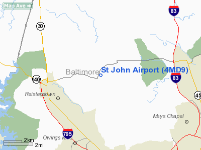
Location & QuickFacts
| FAA Information Effective: | 2008-09-25 |
| Airport Identifier: | 4MD9 |
| Airport Status: | Operational |
| Longitude/Latitude: | 076-45-38.0000W/39-28-50.0000N
-76.760556/39.480556 (Estimated) |
| Elevation: | 461 ft / 140.51 m (Surveyed) |
| Land: | 0 acres |
| From nearest city: | 4 nautical miles N of Owings Mills, MD |
| Location: | Baltimore County, MD |
| Magnetic Variation: | 10W (1990) |
Owner & Manager
| Ownership: | Privately owned |
| Owner: | Edward St John |
| Address: | 12757 Green Spring Ave
Owings Mills, MD 21117 |
| Address: |
|
Airport Operations and Facilities
| Airport Use: | Private |
| Segmented Circle: | No |
| Control Tower: | No |
| Sectional chart: | Washington |
| Region: | AEA - Eastern |
| Boundary ARTCC: | ZNY - New York |
| Tie-in FSS: | DCA - Leesburg |
| FSS Toll Free: | 1-800-WX-BRIEF |
Runway Information
Runway 02/20
| Dimension: | 2600 x 120 ft / 792.5 x 36.6 m |
| Surface: | TURF, |
| |
Runway 02 |
Runway 20 |
| Traffic Pattern: | Left | Left |
| Displaced threshold: | 300.00 ft | 0.00 ft |
| Obstruction: | 30 ft pline, 300.0 ft from runway | 18 ft trees, 0.0 ft from runway |
|
Radio Navigation Aids
| ID |
Type |
Name |
Ch |
Freq |
Var |
Dist |
| FND | NDB | Ellicott | | 371.00 | 11W | 11.6 nm |
| IUB | NDB | Institute | | 404.00 | 08W | 13.2 nm |
| MTN | NDB | Martin | | 342.00 | 11W | 20.7 nm |
| BUH | NDB | Anne Arundel | | 260.00 | 10W | 23.8 nm |
| GAI | NDB | Gaithersburg | | 385.00 | 09W | 26.5 nm |
| EUD | NDB | York | | 254.00 | 11W | 27.0 nm |
| APG | NDB | Aberdeen | | 349.00 | 11W | 30.5 nm |
| GTN | NDB | Georgetown | | 323.00 | 09W | 37.2 nm |
| DC | NDB | Oxonn | | 332.00 | 11W | 44.7 nm |
| VKX | NDB | Potomac | | 241.00 | 10W | 44.9 nm |
| MTN | TACAN | Martin | 068X | | 11W | 18.5 nm |
| FDK | VOR | Frederick | | 109.00 | 08W | 28.8 nm |
| PPM | VOR/DME | Phillips | 021X | 108.40 | 09W | 27.4 nm |
| DCA | VOR/DME | Washington | 047X | 111.00 | 09W | 39.5 nm |
| EMI | VORTAC | Westminster | 126X | 117.90 | 08W | 10.2 nm |
| BAL | VORTAC | Baltimore | 098X | 115.10 | 11W | 19.2 nm |
| ADW | VORTAC | Andrews | 078X | 113.10 | 10W | 40.8 nm |
| LRP | VORTAC | Lancaster | 120X | 117.30 | 09W | 44.1 nm |
| AML | VORTAC | Armel | 082X | 113.50 | 08W | 46.5 nm |
| OTT | VORTAC | Nottingham | 084X | 113.70 | 10W | 46.6 nm |
| DCA | VOT | Washington National | | 109.40 | | 40.3 nm |
| ADW | VOT | Andrews Afb | | 109.60 | | 42.0 nm |
| MDT | VOT | Harrisburg International | | 110.00 | | 43.1 nm |
Remarks
- PRVDD ARPT USED DALGT ONLY AND NO IFR OPERATIONS ARE CONDUCTED; THR TO RY 2 IS DSPLCD 300 FT TO PROVIDE 20:1 APCH OVER PLINE; LARGEST CLASS OF ACFT USING ARPT IS LIMITED TO 12500 LBS GROSS TKOF WGT OR LESS, TWIN ENGINE, AND CTC IS MADE WITH ATCT AT BWI ARPT.
Images and information placed above are from
http://www.airport-data.com/airport/4MD9/
We thank them for the data!
| General Info
|
| Country |
United States
|
| State |
MARYLAND
|
| FAA ID |
4MD9
|
| Latitude |
39-28-50.000N
|
| Longitude |
076-45-38.000W
|
| Elevation |
461 feet
|
| Near City |
OWINGS MILLS
|
We don't guarantee the information is fresh and accurate. The data may
be wrong or outdated.
For more up-to-date information please refer to other sources.
|
|


