 |
|
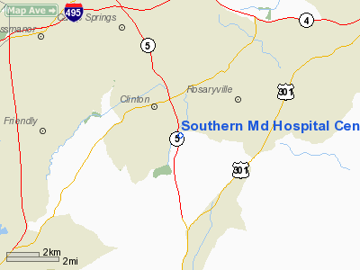
Southern Md Hospital Center Heliport |
Location & QuickFacts
| FAA Information Effective: | 2008-09-25 |
| Airport Identifier: | 3MD1 |
| Airport Status: | Operational |
| Longitude/Latitude: | 076-52-38.0000W/38-44-53.0000N
-76.877222/38.748056 (Estimated) |
| Elevation: | 210 ft / 64.01 m (Estimated) |
| Land: | 0 acres |
| From nearest city: | 2 nautical miles SW of Clinton, MD |
| Location: | Prince Georges County, MD |
| Magnetic Variation: | 10W (1995) |
Owner & Manager
| Ownership: | Privately owned |
| Owner: | Southern Md Hospital Center |
| Address: | 7503 Surratts Rd
Clinton, MD 20735 |
| Phone number: | 301-899-4530 |
| Manager: | Robt D. Mullady |
| Address: | 7503 Surratts Rd
Clinton, MD 20735 |
| Phone number: | 301-899-4684 |
Airport Operations and Facilities
| Airport Use: | Private
MEDICAL USE. |
| Wind indicator: | Yes |
| Segmented Circle: | No |
| Control Tower: | No |
| Lighting Schedule: | RDO-CTL
ACTIVATE PERIMETER LGTS - 123.05 |
| Sectional chart: | Washington |
| Region: | AEA - Eastern |
| Boundary ARTCC: | ZDC - Washington |
| Tie-in FSS: | DCA - Leesburg |
| FSS Toll Free: | 1-800-WX-BRIEF |
Runway Information
Helipad H1
| Dimension: | 62 x 50 ft / 18.9 x 15.2 m |
| Surface: | CONC, |
| |
Runway H1 |
Runway |
| Traffic Pattern: | Left | Left |
|
Radio Navigation Aids
| ID |
Type |
Name |
Ch |
Freq |
Var |
Dist |
| VKX | NDB | Potomac | | 241.00 | 10W | 3.7 nm |
| DC | NDB | Oxonn | | 332.00 | 11W | 7.1 nm |
| GTN | NDB | Georgetown | | 323.00 | 09W | 15.9 nm |
| BUH | NDB | Anne Arundel | | 260.00 | 10W | 20.9 nm |
| GAI | NDB | Gaithersburg | | 385.00 | 09W | 28.7 nm |
| FND | NDB | Ellicott | | 371.00 | 11W | 32.8 nm |
| IUB | NDB | Institute | | 404.00 | 08W | 34.5 nm |
| NHK | NDB | Patuxent | | 400.00 | 10W | 35.6 nm |
| ESN | NDB | Easton | | 212.00 | 10W | 38.0 nm |
| EZF | NDB | Shannon | | 237.00 | 10W | 39.6 nm |
| MTN | NDB | Martin | | 342.00 | 11W | 40.5 nm |
| CGE | NDB | Cambridge | | 355.00 | 10W | 41.6 nm |
| APH | NDB | A P Hill | | 396.00 | 10W | 44.9 nm |
| GDX | NDB | Goodwin Lake | | 227.00 | 08W | 46.3 nm |
| CJR | NDB | Culpeper | | 252.00 | 09W | 47.9 nm |
| MTN | TACAN | Martin | 068X | | 11W | 41.2 nm |
| FDK | VOR | Frederick | | 109.00 | 08W | 46.2 nm |
| DCA | VOR/DME | Washington | 047X | 111.00 | 09W | 10.0 nm |
| ADW | VORTAC | Andrews | 078X | 113.10 | 10W | 3.6 nm |
| OTT | VORTAC | Nottingham | 084X | 113.70 | 10W | 6.7 nm |
| BAL | VORTAC | Baltimore | 098X | 115.10 | 11W | 27.4 nm |
| AML | VORTAC | Armel | 082X | 113.50 | 08W | 29.8 nm |
| BRV | VORTAC | Brooke | 092X | 114.50 | 09W | 33.4 nm |
| PXT | VORTAC | Patuxent | 123X | 117.60 | 10W | 35.6 nm |
| EMI | VORTAC | Westminster | 126X | 117.90 | 08W | 45.1 nm |
| CSN | VORTAC | Casanova | 110X | 116.30 | 06W | 46.8 nm |
| ADW | VOT | Andrews Afb | | 109.60 | | 2.4 nm |
| DCA | VOT | Washington National | | 109.40 | | 9.4 nm |
Remarks
- PVDD FLAG POLE LIGHTED; NO IFR OPNS; CLEAR 8:1 INGRESS/EGRESS ; PROVISIONS MADE FOR PERSONS & PROPERTY ON GROUND; AREA MKD & WINDSOCK LIGHTED.
Images and information placed above are from
http://www.airport-data.com/airport/3MD1/
We thank them for the data!
| General Info
|
| Country |
United States
|
| State |
MARYLAND
|
| FAA ID |
3MD1
|
| Latitude |
38-44-53.000N
|
| Longitude |
076-52-38.000W
|
| Elevation |
210 feet
|
| Near City |
CLINTON
|
We don't guarantee the information is fresh and accurate. The data may
be wrong or outdated.
For more up-to-date information please refer to other sources.
|
|


