 |
|
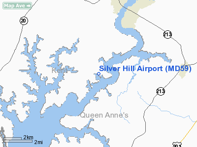
Location & QuickFacts
| FAA Information Effective: | 2008-09-25 |
| Airport Identifier: | MD59 |
| Airport Status: | Operational |
| Longitude/Latitude: | 076-05-36.8080W/39-08-23.3970N
-76.093558/39.139832 (Estimated) |
| Elevation: | 30 ft / 9.14 m (Estimated) |
| Land: | 115 acres |
| From nearest city: | 5 nautical miles SW of Chestertown, MD |
| Location: | Kent County, MD |
| Magnetic Variation: | 11W (1990) |
Owner & Manager
| Ownership: | Privately owned |
| Owner: | Daniel W. Ingersoll |
| Address: | 25047 Learman Rd
Chestertown, MD 21620 |
| Phone number: | 410-778-0636 |
| Manager: | Daniel W. Ingersoll |
| Address: | Rte 3, Box 105
Chestertown, MD 21620 |
| Phone number: | 410-778-0636 |
Airport Operations and Facilities
| Airport Use: | Private |
| Wind indicator: | Yes |
| Segmented Circle: | No |
| Control Tower: | No |
| Sectional chart: | Washington |
| Region: | AEA - Eastern |
| Boundary ARTCC: | ZDC - Washington |
| Tie-in FSS: | DCA - Leesburg |
| FSS on Airport: | No |
| FSS Toll Free: | 1-800-WX-BRIEF |
Runway Information
Runway 17/35
| Dimension: | 2500 x 40 ft / 762.0 x 12.2 m |
| Surface: | TURF, Good Condition |
| |
Runway 17 |
Runway 35 |
| Traffic Pattern: | Left | Left |
| Obstruction: | 40 ft trees, 350.0 ft from runway | |
|
Radio Navigation Aids
| ID |
Type |
Name |
Ch |
Freq |
Var |
Dist |
| MTN | NDB | Martin | | 342.00 | 11W | 16.4 nm |
| ESN | NDB | Easton | | 212.00 | 10W | 20.2 nm |
| APG | NDB | Aberdeen | | 349.00 | 11W | 23.8 nm |
| IUB | NDB | Institute | | 404.00 | 08W | 26.3 nm |
| BUH | NDB | Anne Arundel | | 260.00 | 10W | 31.3 nm |
| FND | NDB | Ellicott | | 371.00 | 11W | 33.0 nm |
| CGE | NDB | Cambridge | | 355.00 | 10W | 36.3 nm |
| VKX | NDB | Potomac | | 241.00 | 10W | 46.7 nm |
| RNB | NDB | Rainbow | | 363.00 | 11W | 47.6 nm |
| DC | NDB | Oxonn | | 332.00 | 11W | 49.1 nm |
| GTN | NDB | Georgetown | | 323.00 | 09W | 49.7 nm |
| MTN | TACAN | Martin | 068X | | 11W | 18.7 nm |
| DOV | TACAN | Dover | 037X | | 09W | 29.2 nm |
| PPM | VOR/DME | Phillips | 021X | 108.40 | 09W | 20.0 nm |
| ATR | VOR/DME | Waterloo | 073X | 112.60 | 09W | 45.7 nm |
| DCA | VOR/DME | Washington | 047X | 111.00 | 09W | 47.2 nm |
| BAL | VORTAC | Baltimore | 098X | 115.10 | 11W | 26.5 nm |
| ENO | VORTAC | Smyrna | 051X | 111.40 | 09W | 27.5 nm |
| DQO | VORTAC | Dupont | 087X | 114.00 | 10W | 39.5 nm |
| OTT | VORTAC | Nottingham | 084X | 113.70 | 10W | 40.1 nm |
| ADW | VORTAC | Andrews | 078X | 113.10 | 10W | 41.3 nm |
| EMI | VORTAC | Westminster | 126X | 117.90 | 08W | 46.4 nm |
| OOD | VORTAC | Woodstown | 075X | 112.80 | 10W | 47.3 nm |
| ADW | VOT | Andrews Afb | | 109.60 | | 42.4 nm |
| DCA | VOT | Washington National | | 109.40 | | 47.4 nm |
Remarks
- PRVDD ARPT OPS USED FORVFR DALGT; LARGEST CLASS ACFT RCMD FOR OPS 3500 LBS MAX GWT; BE AWARE LOC OF NEARBY ARPTS APPEAR REVERSE OF DIR REQD; TREES N OF ARPT BE RMVD OR TOPPED TOPROVIDE 20:1 APCH SFC TO RY 17; CTC OPS OF NEARBY ARPTS INCL RAMSEY FLD LISTEDON FORM 7480-1 TO ESTAB COORD WITH THEIR OPS.
Images and information placed above are from
http://www.airport-data.com/airport/MD59/
We thank them for the data!
| General Info
|
| Country |
United States
|
| State |
MARYLAND
|
| FAA ID |
MD59
|
| Latitude |
39-08-23.397N
|
| Longitude |
076-05-36.808W
|
| Elevation |
30 feet
|
| Near City |
CHESTERTOWN
|
We don't guarantee the information is fresh and accurate. The data may
be wrong or outdated.
For more up-to-date information please refer to other sources.
|
|


