 |
|
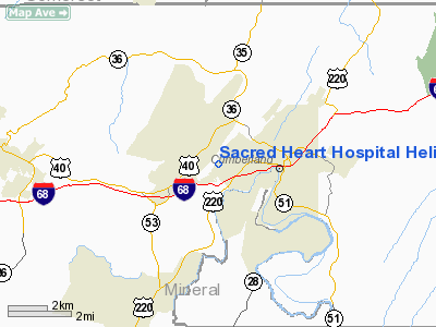
Sacred Heart Hospital Heliport |
Location & QuickFacts
| FAA Information Effective: | 2008-09-25 |
| Airport Identifier: | MD07 |
| Airport Status: | Operational |
| Longitude/Latitude: | 078-47-59.0700W/39-39-00.3150N
-78.799742/39.650087 (Estimated) |
| Elevation: | 1428 ft / 435.25 m (Estimated) |
| Land: | 0 acres |
| From nearest city: | 3 nautical miles W of Cumberland, MD |
| Location: | Allegany County, MD |
| Magnetic Variation: | 08W (1985) |
Owner & Manager
| Ownership: | Privately owned |
| Owner: | Sacred Heart Hospital |
| Address: | 900 Seton Drive
Cumberland, MD 21502 |
| Manager: | James C. Twiqq, V.p./e.s. |
| Address: | Sacred Heart Hospital
Cumberland, MD 21502 |
| Phone number: | 301-759-4200 |
Airport Operations and Facilities
| Airport Use: | Private
MEDICAL USE. |
| Wind indicator: | Yes |
| Segmented Circle: | No |
| Control Tower: | No |
| Lighting Schedule: | PHONE REQ
FOR HELIPAD PERIMETER LGTS CALL 301-759-4200. |
| Landing fee charge: | No |
| Sectional chart: | Washington |
| Region: | AEA - Eastern |
| Boundary ARTCC: | ZOB - Cleveland |
| Tie-in FSS: | EKN - Elkins |
| FSS on Airport: | No |
| FSS Toll Free: | 1-800-WX-BRIEF |
Airport Services
| Airframe Repair: | NONE |
| Power Plant Repair: | NONE |
Runway Information
Helipad H1
| Dimension: | 44 x 44 ft / 13.4 x 13.4 m |
| Surface: | CONC, |
| |
Runway H1 |
Runway |
| Traffic Pattern: | Left | Left |
| Obstruction: | 75 ft bldg, 150.0 ft from runway | |
|
Radio Navigation Aids
| ID |
Type |
Name |
Ch |
Freq |
Var |
Dist |
| CBE | NDB | Cumberland | | 317.00 | 07W | 2.4 nm |
| SYS | NDB | Stoystown | | 209.00 | 08W | 26.7 nm |
| VV | NDB | Camor | | 299.00 | 08W | 45.8 nm |
| TZ | NDB | Cogan | | 364.00 | 10W | 48.0 nm |
| BHU | NDB | Benje | | 382.00 | 07W | 48.7 nm |
| HGR | VOR | Hagerstown | | 109.80 | 07W | 43.8 nm |
| AOO | VOR | Altoona | | 108.80 | 07W | 46.6 nm |
| GRV | VOR/DME | Grantsville | 070X | 112.30 | 06W | 11.6 nm |
| ESL | VOR/DME | Kessel | 045X | 110.80 | 06W | 27.0 nm |
| IHD | VORTAC | Indian Head | 019X | 108.20 | 06W | 32.3 nm |
| JST | VORTAC | Johnstown | 077X | 113.00 | 06W | 40.1 nm |
| THS | VORTAC | St Thomas | 097X | 115.00 | 07W | 42.7 nm |
| MRB | VORTAC | Martinsburg | 058X | 112.10 | 07W | 46.9 nm |
| MGW | VORTAC | Morgantown | 053X | 111.60 | 05W | 49.4 nm |
Remarks
Images and information placed above are from
http://www.airport-data.com/airport/MD07/
We thank them for the data!
| General Info
|
| Country |
United States
|
| State |
MARYLAND
|
| FAA ID |
MD07
|
| Latitude |
39-39-00.315N
|
| Longitude |
078-47-59.070W
|
| Elevation |
1428 feet
|
| Near City |
CUMBERLAND
|
We don't guarantee the information is fresh and accurate. The data may
be wrong or outdated.
For more up-to-date information please refer to other sources.
|
|


