 |
|
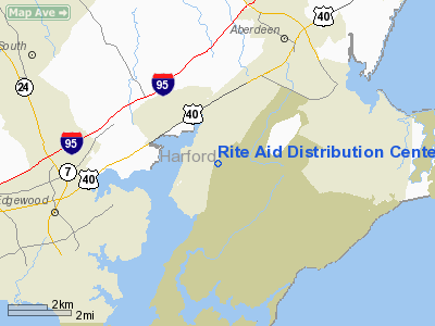
Rite Aid Distribution Center Heliport |
Location & QuickFacts
| FAA Information Effective: | 2008-09-25 |
| Airport Identifier: | 8MD1 |
| Airport Status: | Operational |
| Longitude/Latitude: | 076-12-33.8300W/39-27-12.3900N
-76.209397/39.453442 (Estimated) |
| Elevation: | 35 ft / 10.67 m (Estimated) |
| Land: | 0 acres |
| From nearest city: | 4 nautical miles SW of Aberdeen, MD |
| Location: | Harford County, MD |
| Magnetic Variation: | 11W (1995) |
Owner & Manager
| Ownership: | Privately owned |
| Owner: | Rite Aid Corp |
| Address: | 30 Hunter La
Camp Hill, PA 17105 |
| Phone number: | 727-972-3914 |
| Manager: | Keith Hughes |
| Address: | Box 3165
Harrisburg, PA 17105 |
| Phone number: | 717-975-5749 |
Airport Operations and Facilities
| Airport Use: | Private |
| Wind indicator: | Yes |
| Segmented Circle: | No |
| Control Tower: | No |
| Sectional chart: | Washington |
| Region: | AEA - Eastern |
| Boundary ARTCC: | ZDC - Washington |
| Tie-in FSS: | DCA - Leesburg |
| FSS Toll Free: | 1-800-WX-BRIEF |
Runway Information
Helipad H1
| Dimension: | 80 x 80 ft / 24.4 x 24.4 m |
| Surface: | CONC, |
| |
Runway H1 |
Runway |
| Traffic Pattern: | Left | Left |
|
Radio Navigation Aids
| ID |
Type |
Name |
Ch |
Freq |
Var |
Dist |
| APG | NDB | Aberdeen | | 349.00 | 11W | 6.9 nm |
| MTN | NDB | Martin | | 342.00 | 11W | 12.2 nm |
| IUB | NDB | Institute | | 404.00 | 08W | 21.8 nm |
| FND | NDB | Ellicott | | 371.00 | 11W | 28.2 nm |
| BUH | NDB | Anne Arundel | | 260.00 | 10W | 33.9 nm |
| ESN | NDB | Easton | | 212.00 | 10W | 39.5 nm |
| EUD | NDB | York | | 254.00 | 11W | 41.7 nm |
| GAI | NDB | Gaithersburg | | 385.00 | 09W | 47.6 nm |
| RNB | NDB | Rainbow | | 363.00 | 11W | 49.9 nm |
| MTN | TACAN | Martin | 068X | | 11W | 11.9 nm |
| DOV | TACAN | Dover | 037X | | 09W | 39.5 nm |
| PPM | VOR/DME | Phillips | 021X | 108.40 | 09W | 2.0 nm |
| BAL | VORTAC | Baltimore | 098X | 115.10 | 11W | 27.0 nm |
| DQO | VORTAC | Dupont | 087X | 114.00 | 10W | 31.0 nm |
| ENO | VORTAC | Smyrna | 051X | 111.40 | 09W | 34.9 nm |
| EMI | VORTAC | Westminster | 126X | 117.90 | 08W | 35.8 nm |
| MXE | VORTAC | Modena | 079X | 113.20 | 09W | 37.4 nm |
| LRP | VORTAC | Lancaster | 120X | 117.30 | 09W | 40.2 nm |
| OOD | VORTAC | Woodstown | 075X | 112.80 | 10W | 43.4 nm |
| ADW | VORTAC | Andrews | 078X | 113.10 | 10W | 49.5 nm |
Remarks
- PRVDD VFR ONLY, CLEAR 8:1 INGRESS/EGRESS, VEHICULAR TFC AROUND SITE CONTROLLED, LIGHTING AT NIGHT DURG OPNS, APPROPRIATE INGRESS/EGESS MKGS, ARRANGEMENTS MADE WITH PHILLIPS ARMY AIRFIELD ATCT FOR SERVICES.
Images and information placed above are from
http://www.airport-data.com/airport/8MD1/
We thank them for the data!
| General Info
|
| Country |
United States
|
| State |
MARYLAND
|
| FAA ID |
8MD1
|
| Latitude |
39-27-12.390N
|
| Longitude |
076-12-33.830W
|
| Elevation |
35 feet
|
| Near City |
ABERDEEN
|
We don't guarantee the information is fresh and accurate. The data may
be wrong or outdated.
For more up-to-date information please refer to other sources.
|
|


