|
|
|
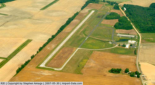 |
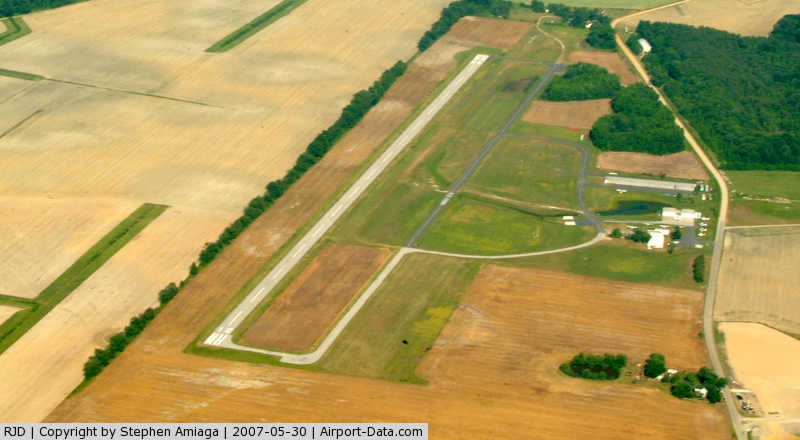
(Click on the photo to enlarge) |
Location & QuickFacts
| FAA Information Effective: | 2008-09-25 |
| Airport Identifier: | RJD |
| Airport Status: | Operational |
| Longitude/Latitude: | 075-51-58.7680W/38-58-12.4080N
-75.866324/38.970113 (Estimated) |
| Elevation: | 64 ft / 19.51 m (Surveyed) |
| Land: | 76 acres |
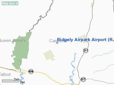
| From nearest city: | 2 nautical miles NE of Ridgely, MD |
| Location: | Caroline County, MD |
| Magnetic Variation: | 12W (2005) |
Owner & Manager
| Ownership: | Privately owned |
| Owner: | Tracy Coleman |
| Address: | 1203 Iraquois Dr
Crownsville, MD 21032 |
| Phone number: | 410-923-3660 |
| Manager: | Tom Davis |
| Address: | 24030 Racetrack Rd, Ste 3
Ridgely, MD 21108 |
| Phone number: | 410-634-2806 |
Airport Operations and Facilities
| Airport Use: | Open to public |
| Wind indicator: | Yes |
| Segmented Circle: | No |
| Control Tower: | No |
| Lighting Schedule: | DUSK-DAWN
ACTVT LIRL RY 12/30 & REIL RYS 12 & 30 - CTAF. |
| Beacon Color: | Clear-Green (lighted land airport) |
| Landing fee charge: | No |
| Sectional chart: | Washington |
| Region: | AEA - Eastern |
| Boundary ARTCC: | ZDC - Washington |
| Tie-in FSS: | DCA - Leesburg |
| FSS on Airport: | No |
| FSS Toll Free: | 1-800-WX-BRIEF |
| NOTAMs Facility: | DCA (NOTAM-d service avaliable) |
Airport Communications
| CTAF: | 122.800 |
| Unicom: | 122.800
UNICOM UNMONITORED. |
Airport Services
| Fuel available: | 100LLA |
| Airframe Repair: | MAJOR |
| Power Plant Repair: | MAJOR |
Runway Information
Runway 12/30
| Dimension: | 3214 x 50 ft / 979.6 x 15.2 m |
| Surface: | ASPH, Fair Condition |
| Weight Limit: | Single wheel: 28000 lbs.
Dual wheel: 39000 lbs. |
| Edge Lights: | Low |
| |
Runway 12 |
Runway 30 |
| Longitude: | 075-52-25.8300W | 075-51-47.4000W |
| Latitude: | 38-58-19.6700N | 38-58-09.2200N |
| Elevation: | 64.00 ft | 64.00 ft |
| Alignment: | 109 | 127 |
| Traffic Pattern: | Left | Left |
| Markings: | Non-precision instrument, Fair Condition | Non-precision instrument, Fair Condition |
| Runway End Identifier: | Yes | Yes |
| Obstruction: | 36 ft trees, 354.0 ft from runway, 229 ft left of centerline, 4:1 slope to clear
TREELINE PARALLEL TO RWY. +20' 240'L | 74 ft trees, 583.0 ft from runway, 259 ft left of centerline, 5:1 slope to clear
TREE LINE PARALLEL TO RWY. +25', 240'R |
|
Radio Navigation Aids
| ID |
Type |
Name |
Ch |
Freq |
Var |
Dist |
| ESN | NDB | Easton | | 212.00 | 10W | 13.7 nm |
| CGE | NDB | Cambridge | | 355.00 | 10W | 27.1 nm |
| MTN | NDB | Martin | | 342.00 | 11W | 31.1 nm |
| APG | NDB | Aberdeen | | 349.00 | 11W | 35.8 nm |
| IUB | NDB | Institute | | 404.00 | 08W | 40.2 nm |
| BUH | NDB | Anne Arundel | | 260.00 | 10W | 42.3 nm |
| RNB | NDB | Rainbow | | 363.00 | 11W | 43.4 nm |
| FND | NDB | Ellicott | | 371.00 | 11W | 46.5 nm |
| OX | NDB | Landy | | 407.00 | 12W | 48.1 nm |
| NHK | NDB | Patuxent | | 400.00 | 10W | 48.2 nm |
| DOV | TACAN | Dover | 037X | | 09W | 21.0 nm |
| MTN | TACAN | Martin | 068X | | 11W | 33.4 nm |
| ATR | VOR/DME | Waterloo | 073X | 112.60 | 09W | 32.1 nm |
| PPM | VOR/DME | Phillips | 021X | 108.40 | 09W | 33.0 nm |
| ENO | VORTAC | Smyrna | 051X | 111.40 | 09W | 22.7 nm |
| BAL | VORTAC | Baltimore | 098X | 115.10 | 11W | 39.0 nm |
| SBY | VORTAC | Salisbury | 049X | 111.20 | 12W | 41.1 nm |
| OTT | VORTAC | Nottingham | 084X | 113.70 | 10W | 44.1 nm |
| DQO | VORTAC | Dupont | 087X | 114.00 | 10W | 44.2 nm |
| ADW | VORTAC | Andrews | 078X | 113.10 | 10W | 47.8 nm |
| OOD | VORTAC | Woodstown | 075X | 112.80 | 10W | 47.8 nm |
| PXT | VORTAC | Patuxent | 123X | 117.60 | 10W | 48.1 nm |
| ADW | VOT | Andrews Afb | | 109.60 | | 48.7 nm |
Remarks
- HANG GLIDER OPNS ON & INVOF ARPT.
- TURF AREAS ADJACENT TO ACFT MOVEMENT AREAS SOFT WHEN WET.
- UNLIMITED VEHICLE ACCESS TO ACFT MOVEMENT AREAS.
- BIRDS & WILDLIFE ON & INVOF ARPT.
- VFR USE ONLY.
Images and information placed above are from
http://www.airport-data.com/airport/RJD/
We thank them for the data!
| General Info
|
| Country |
United States
|
| State |
MARYLAND
|
| FAA ID |
RJD
|
| Latitude |
38-58-12.408N
|
| Longitude |
075-51-58.768W
|
| Elevation |
64 feet
|
| Near City |
RIDGELY
|
We don't guarantee the information is fresh and accurate. The data may
be wrong or outdated.
For more up-to-date information please refer to other sources.
|
|