|
|
| Potomac Airfield |
| IATA: none – ICAO: KVKX – FAA LID: VKX |
| Summary |
| Airport type |
Public |
| Owner |
Copley Investments |
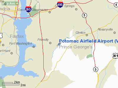
| Location |
Fort Washington, Maryland |
| Elevation AMSL |
118 ft / 36 m |
| Coordinates |
38°44′55″N 076°57′21″W / 38.74861°N 76.95583°W / 38.74861; -76.95583 |
| Website |
Potomac-Airfield.com |
| Runways |
| Direction |
Length |
Surface |
| ft |
m |
| 6/24 |
2,665 |
812 |
Asphalt |
| Statistics |
| Based aircraft |
91 |
| Source: FAA and airport website |
Potomac Airfield (ICAO: KVKX, FAA LID: VKX), also known as Potomac Airport or Potomac Airpark, is a privately-owned, public-use airport located in the community of Fort Washington (formerly known as Friendly), in Prince Georges County, Maryland, United States (just outside Washington, D.C.). It is a general aviation airport, and there is no scheduled airline service available.
Potomac Airfield is located in the Flight Restricted Zone (FRZ) in the center of the Washington, D.C. Air Defense Identification Zone. Pilots are required to apply for a special security clearance before they are permitted to fly into Potomac Airfield (or the other two general aviation airports in the FRZ, College Park Airport and Washington Executive Airport/Hyde Field). Pilots without prior clearance (through a special vetting process) may not operate aircraft within the FRZ zone surrounding Washington, DC. Non-based pilots can get cleared but if you are planning a trip to DC and want to use Potomac Airfield, Hyde Executive or College park, you should begin the process of getting vetted at least 30 days in advance or there is no way you will be able to land at these airports. To find out more visit http://www.potomac-airfield.com or contact Potomac Airfield at 301-248-5720
Although most U.S. airports use the same three-letter location identifier for the FAA and IATA, Potomac Airfield is assigned VKX by the FAA but has no designation from the IATA.
Facilities and aircraft
Potomac Airfield Airport covers an area of 50 acres (20 ha) which contains one asphalt paved runway (6/24) measuring 2,665 x 40 ft (812 x 12 m). There are 91 aircraft based at this airport: 97% single engine and 3% multi-engine.
A.T.C. Flight Training Center [1] is the primary FBO on the field providing flight training and a pilot shop located in the main building. A.T.C. offers a unique program where students pay a flat monthly rate for use of the aircraft and can fly almost as much as they want without an hourly fees (Currently $400 per month and student buys their own fuel from the airport and pays for instruction) as well as hourly rentals. Contact info: website http://www.lrn2fly.com Phone 301-248-1480. Hours of operation 7 days a week 0900 to 1800 local
The above content comes from Wikipedia and is published under free licenses – click here to read more.
|
 |
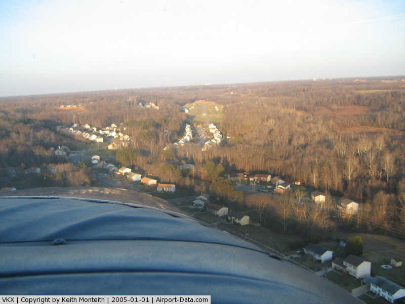
(Click on the photo to enlarge) |
Location & QuickFacts
| FAA Information Effective: | 2008-09-25 |
| Airport Identifier: | VKX |
| Airport Status: | Operational |
| Longitude/Latitude: | 076-57-21.3200W/38-44-55.1100N
-76.955922/38.748642 (Estimated) |
| Elevation: | 118 ft / 35.97 m (Estimated) |
| Land: | 50 acres |
| From nearest city: | 0 nautical miles NE of Friendly, MD |
| Location: | Prince Georges County, MD |
| Magnetic Variation: | 11W (2000) |
Owner & Manager
| Ownership: | Privately owned |
| Owner: | Copley Investments |
| Address: | 10 Newbury St
Boston, MA 02116 |
| Phone number: | 617-267-6828 |
| Manager: | David Wartofsky |
| Address: | 10300 Glen Way
Fort Washington, MD 20744 |
| Phone number: | 301-248-5720 |
Airport Operations and Facilities
| Airport Use: | Open to public |
| Wind indicator: | Yes |
| Segmented Circle: | Yes |
| Control Tower: | No |
| Lighting Schedule: | DUSK-DAWN
ACTVT REIL RYS 06 & 24 - CTAF |
| Beacon Color: | Clear-Green (lighted land airport)
ROTG BCN LOCATED 1000 FT N OF ARPT. |
| Landing fee charge: | No |
| Sectional chart: | Washington |
| Region: | AEA - Eastern |
| Boundary ARTCC: | ZDC - Washington |
| Tie-in FSS: | DCA - Leesburg |
| FSS on Airport: | No |
| FSS Toll Free: | 1-800-WX-BRIEF |
| NOTAMs Facility: | DCA (NOTAM-d service avaliable) |
Airport Communications
| CTAF: | 122.800 |
| Unicom: | 122.800
AUTOMATED UNICOM - 3 CLICKS FOR ARPT ADVISORY & WEATHER, 4 CLICKS FOR RADIO CHECK. |
Airport Services
| Fuel available: | 100LL |
| Airframe Repair: | MAJOR |
| Power Plant Repair: | MAJOR |
| Bottled Oxygen: | NONE |
| Bulk Oxygen: | NONE |
Runway Information
Runway 06/24
| Dimension: | 2665 x 40 ft / 812.3 x 12.2 m |
| Surface: | ASPH, Good Condition |
| Surface Treatment: | Aggregate Friction Seal Coat |
| Edge Lights: | Medium |
| |
Runway 06 |
Runway 24 |
| Longitude: | 076-57-33.9100W | 076-57-08.7300W |
| Latitude: | 38-44-46.3800N | 38-45-03.8400N |
| Elevation: | 109.00 ft | 118.00 ft |
| Alignment: | 48 | 127 |
| Traffic Pattern: | Left | Right |
| Markings: | Non-precision instrument, Good Condition | Nonstandard, Good Condition
BASIC MKGS PLUS FIELD CARRIER LDG PRACTICE (FCLP) MKGS. |
| Crossing Height: | 38.00 ft | 49.00 ft |
| Displaced threshold: | 385.00 ft | 84.00 ft |
| VASI: | system of panels on right side that may or may not be lighted | system of panels on left side that may or may not be lighted |
| Visual Glide Angle: | 5.00° | 5.50° |
| Runway End Identifier: | Yes | Yes |
| Obstruction: | 99 ft trees, 562.0 ft from runway, 250 ft right of centerline, 3:1 slope to clear
APCH RATIO 20:1 TO DSPLCD THLD.
+50 FT TREES 175 FT R AT THLD. | 63 ft trees, 1210.0 ft from runway, 16:1 slope to clear
APCH RATIO 28:1 TO DSPLCD THLD. |
|
Radio Navigation Aids
| ID |
Type |
Name |
Ch |
Freq |
Var |
Dist |
| DC | NDB | Oxonn | | 332.00 | 11W | 3.5 nm |
| GTN | NDB | Georgetown | | 323.00 | 09W | 13.4 nm |
| BUH | NDB | Anne Arundel | | 260.00 | 10W | 22.1 nm |
| GAI | NDB | Gaithersburg | | 385.00 | 09W | 27.1 nm |
| FND | NDB | Ellicott | | 371.00 | 11W | 33.4 nm |
| IUB | NDB | Institute | | 404.00 | 08W | 35.9 nm |
| EZF | NDB | Shannon | | 237.00 | 10W | 37.2 nm |
| NHK | NDB | Patuxent | | 400.00 | 10W | 38.1 nm |
| ESN | NDB | Easton | | 212.00 | 10W | 41.7 nm |
| MTN | NDB | Martin | | 342.00 | 11W | 42.7 nm |
| GDX | NDB | Goodwin Lake | | 227.00 | 08W | 42.8 nm |
| APH | NDB | A P Hill | | 396.00 | 10W | 43.4 nm |
| CJR | NDB | Culpeper | | 252.00 | 09W | 44.3 nm |
| CGE | NDB | Cambridge | | 355.00 | 10W | 45.2 nm |
| MSQ | NDB | Nailr | | 351.00 | 10W | 48.0 nm |
| MTN | TACAN | Martin | 068X | | 11W | 43.3 nm |
| FDK | VOR | Frederick | | 109.00 | 08W | 44.4 nm |
| DCA | VOR/DME | Washington | 047X | 111.00 | 09W | 7.7 nm |
| ADW | VORTAC | Andrews | 078X | 113.10 | 10W | 5.5 nm |
| OTT | VORTAC | Nottingham | 084X | 113.70 | 10W | 10.2 nm |
| AML | VORTAC | Armel | 082X | 113.50 | 08W | 26.4 nm |
| BAL | VORTAC | Baltimore | 098X | 115.10 | 11W | 28.9 nm |
| BRV | VORTAC | Brooke | 092X | 114.50 | 09W | 31.0 nm |
| PXT | VORTAC | Patuxent | 123X | 117.60 | 10W | 38.1 nm |
| CSN | VORTAC | Casanova | 110X | 116.30 | 06W | 43.2 nm |
| EMI | VORTAC | Westminster | 126X | 117.90 | 08W | 44.9 nm |
| ADW | VOT | Andrews Afb | | 109.60 | | 4.3 nm |
| DCA | VOT | Washington National | | 109.40 | | 6.8 nm |
Remarks
- UNLIMITED VEHICLE ACCESS TO ACFT MOVEMENT AREAS.
- VISITORS PLEASE TUNE 122.85 FOR PARKING INSTRUCTIONS & GND SVCS.
- COMPLIANCE WITH SFAR 94 IS REQUIRED BEFORE PILOTS MAY OPERATE TO/FROM THIS AIRPORT.
- NOISE ABATEMENT PROCEDURES: AVOID TAKEOFF 2200-0700.
- EXPECT 24 HR SECURITY FROM POLICE, MILITARY & OTHERS ON THE GROUND AND IN THE AIR.
- ARPT WITHIN FLIGHT RESTRICTED ZONE.
- ESTAB PRIOR TO 1959
Images and information placed above are from
http://www.airport-data.com/airport/VKX/
We thank them for the data!
| General Info
|
| Country |
United States
|
| State |
MARYLAND
|
| FAA ID |
VKX
|
| Latitude |
38-44-51.412N
|
| Longitude |
076-57-25.906W
|
| Elevation |
115 feet
|
| Near City |
FRIENDLY
|
We don't guarantee the information is fresh and accurate. The data may
be wrong or outdated.
For more up-to-date information please refer to other sources.
|
|