 |
|
| Phillips Army Airfield |
| IATA: APG – ICAO: KAPG – FAA LID: APG |
| Summary |
| Airport type |
Military |
| Owner |
United States Army |
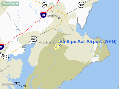
| Location |
Aberdeen Proving Ground, Maryland |
| Elevation AMSL |
57 ft / 17 m |
| Coordinates |
39°27′58″N 076°10′08″W / 39.46611°N 76.16889°W / 39.46611; -76.16889 |
| Runways |
| Direction |
Length |
Surface |
| ft |
m |
| 4/22 |
7,997 |
2,437 |
Asphalt |
| 8/26 |
4,849 |
1,478 |
Asphalt |
| 17/35 |
5,004 |
1,525 |
Asphalt |
| Source: Federal Aviation Administration |
Phillips Army Airfield (IATA: APG, ICAO: KAPG, FAA LID: APG) is a military airport located at Aberdeen Proving Ground, in Harford County, Maryland, United States. This U.S. Army airfield has three asphalt paved runways: 4/22 is 7,997 by 200 feet (2,437 x 61 m), 8/26 is 4,849 by 149 feet (1,478 x 45 m) and 17/35 is 5,004 by 149 feet (1,525 x 45 m).
The above content comes from Wikipedia and is published under free licenses – click here to read more.
|
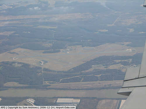 |
(Click on the photo to enlarge) |
Location & QuickFacts
| FAA Information Effective: | 2008-09-25 |
| Airport Identifier: | APG |
| Airport Status: | Operational |
| Longitude/Latitude: | 076-10-07.7100W/39-27-58.3900N
-76.168808/39.466219 (Estimated) |
| Elevation: | 57 ft / 17.37 m (Surveyed) |
| Land: | 0 acres |
| From nearest city: | 2 nautical miles S of Aberdeen Proving Grounds(aberdeen), MD |
| Location: | Harford County, MD |
| Magnetic Variation: | 10W (1985) |
Owner & Manager
| Ownership: | Army owned |
| Owner: | Us Army Atca-aso |
| Address: | Cameron Sta
Alexandria, VA 22314 |
| Address: |
|
| Phone number: | 410-278-4902 |
Airport Operations and Facilities
| Airport Use: | Private |
| Segmented Circle: | No |
| Control Tower: | Yes |
| Lighting Schedule: | DUSK-DAWN |
| Beacon Color: | Split-Clear-Green (lighted military airport) |
| Sectional chart: | Washington |
| Region: | AEA - Eastern |
| Boundary ARTCC: | ZDC - Washington |
| Tie-in FSS: | DCA - Leesburg |
| FSS on Airport: | No |
| FSS Toll Free: | 1-800-WX-BRIEF |
| NOTAMs Facility: | DCA (NOTAM-d service avaliable) |
Runway Information
Runway 04/22
| Dimension: | 7997 x 200 ft / 2437.5 x 61.0 m |
| Surface: | ASPH, |
| Pavement Class: | 26 /F/B/W/T |
| Edge Lights: | High |
| |
Runway 04 |
Runway 22 |
| Longitude: | 076-10-30.1400W | 076-09-41.5610W |
| Latitude: | 39-27-20.9170N | 39-28-30.4350N |
| Elevation: | 28.00 ft | 45.00 ft |
| Traffic Pattern: | Left | Left |
| VASI: | | pulsating/steady burning on left side |
| Approach lights: | | ODALS |
|
Runway 08/26
| Dimension: | 4849 x 149 ft / 1478.0 x 45.4 m |
| Surface: | ASPH, |
| Pavement Class: | 11 /F/B/W/T |
| |
Runway 08 |
Runway 26 |
| Longitude: | 076-10-26.6770W | 076-09-28.0470W |
| Latitude: | 39-28-05.0270N | 39-28-20.2830N |
| Elevation: | 54.00 ft | 35.00 ft |
| Traffic Pattern: | Left | Left |
|
Runway 17/35
| Dimension: | 5004 x 149 ft / 1525.2 x 45.4 m |
| Surface: | ASPH, |
| Pavement Class: | 10 /F/C/W/T |
| |
Runway 17 |
Runway 35 |
| Longitude: | 076-10-30.8550W | 076-10-10.5410W |
| Latitude: | 39-28-12.3350N | 39-27-25.4380N |
| Elevation: | 57.00 ft | 34.00 ft |
| Traffic Pattern: | Left | Left |
|
Radio Navigation Aids
| ID |
Type |
Name |
Ch |
Freq |
Var |
Dist |
| APG | NDB | Aberdeen | | 349.00 | 11W | 5.1 nm |
| MTN | NDB | Martin | | 342.00 | 11W | 14.0 nm |
| IUB | NDB | Institute | | 404.00 | 08W | 23.8 nm |
| FND | NDB | Ellicott | | 371.00 | 11W | 30.2 nm |
| BUH | NDB | Anne Arundel | | 260.00 | 10W | 35.8 nm |
| ESN | NDB | Easton | | 212.00 | 10W | 40.0 nm |
| EUD | NDB | York | | 254.00 | 11W | 42.6 nm |
| RNB | NDB | Rainbow | | 363.00 | 11W | 48.1 nm |
| GAI | NDB | Gaithersburg | | 385.00 | 09W | 49.7 nm |
| MTN | TACAN | Martin | 068X | | 11W | 13.9 nm |
| DOV | TACAN | Dover | 037X | | 09W | 38.3 nm |
| PPM | VOR/DME | Phillips | 021X | 108.40 | 09W | 0.1 nm |
| BAL | VORTAC | Baltimore | 098X | 115.10 | 11W | 29.0 nm |
| DQO | VORTAC | Dupont | 087X | 114.00 | 10W | 29.0 nm |
| ENO | VORTAC | Smyrna | 051X | 111.40 | 09W | 33.5 nm |
| MXE | VORTAC | Modena | 079X | 113.20 | 09W | 35.6 nm |
| EMI | VORTAC | Westminster | 126X | 117.90 | 08W | 37.6 nm |
| LRP | VORTAC | Lancaster | 120X | 117.30 | 09W | 39.7 nm |
| OOD | VORTAC | Woodstown | 075X | 112.80 | 10W | 41.4 nm |
| PHL | VOT | Philadelphia Intl | | 109.80 | | 49.2 nm |
Remarks
- LGT: HIRL RWY 04/22 PPR ONLY.
- FUEL: J8.
- OIL: 0-113-556(MIL).
- REMARKS: OPR 1100-0100Z++ MON-FRI EXC HOL.
- RSTD: PPR ALL ACFT. TRAN ACFT LDG AT ANY SITE OTHER THAN ARPT BEFORE SR OR 1200Z++, WHICHEVER IS LATER OR AFTER SS IS PROH. DSN 298-3483/3074, C410-278-3483/3074. RWY 08/26 LTD TO 25,000 LB GWT. TOUCH AND GO LDG PROH WHILE VEH TEST IN PROGRESS, LO APCH ONLY.
- CAUTION: IMPACT AREA 1200 YD S OF RWY 17/35. DEER HAZ. CTC TWR 15 MIN PRIOR TO ARR TO ARNG DEER SWEEP. IF TWR CLSD USE EXTREME CAUTION.
- NS ABTMT: NOISE SENSITIVE AREA. USE NS ABTMT OPR PRO.
- MISC: CLASS D AIRSPACE EFF 1230-2130Z++ MON-FRI, AND HOL WHEN TWR OPEN, OT CLASS E.
- MISC: ARFF PROTECTION NOT LCTD ON AIRFIELD.
Images and information placed above are from
http://www.airport-data.com/airport/APG/
We thank them for the data!
| General Info
|
| Country |
United States
|
| State |
MARYLAND
|
| FAA ID |
APG
|
| Latitude |
39-27-58.399N
|
| Longitude |
076-10-10.830W
|
| Elevation |
58 feet
|
| Near City |
ABERDEEN PVG GND(ABERDEEN)
|
We don't guarantee the information is fresh and accurate. The data may
be wrong or outdated.
For more up-to-date information please refer to other sources.
|
|


