 |
|
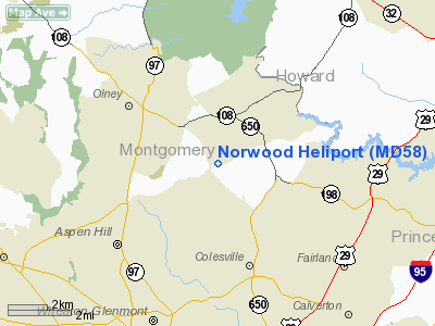
Location & QuickFacts
| FAA Information Effective: | 2008-09-25 |
| Airport Identifier: | MD58 |
| Airport Status: | Operational |
| Longitude/Latitude: | 077-01-21.0000W/39-07-38.0000N
-77.022500/39.127222 (Estimated) |
| Elevation: | 430 ft / 131.06 m (Estimated) |
| Land: | 0 acres |
| From nearest city: | 3 nautical miles E of Olney, MD |
| Location: | Montgomery County, MD |
| Magnetic Variation: | 10W (1990) |
Owner & Manager
| Ownership: | Publicly owned |
| Owner: | Maryland State Police |
| Address: | 16501 Norwood Rd
Sandy Spring, MD 20860 |
| Phone number: | 301-774-8012 |
| Manager: | Sgt Scott Richardson |
| Address: | 16501 Norwood Rd
Sandy Spring, MD 20860 |
| Phone number: | 301-774-8012 |
Airport Operations and Facilities
| Airport Use: | Private |
| Wind indicator: | Yes |
| Segmented Circle: | No |
| Control Tower: | No |
| Lighting Schedule: | PHONE REQ
FOR ROTG BCN & PERIMETER LGTS CALL 301-774-8012. |
| Beacon Color: | Clear-Green-Yellow (heliport) |
| Sectional chart: | Washington |
| Region: | AEA - Eastern |
| Boundary ARTCC: | ZDC - Washington |
| Tie-in FSS: | DCA - Leesburg |
| FSS on Airport: | No |
| FSS Toll Free: | 1-800-WX-BRIEF |
Runway Information
Helipad H1
| Dimension: | 100 x 100 ft / 30.5 x 30.5 m |
| Surface: | CONC, |
| |
Runway H1 |
Runway |
| Traffic Pattern: | Left | Left |
|
Radio Navigation Aids
| ID |
Type |
Name |
Ch |
Freq |
Var |
Dist |
| GAI | NDB | Gaithersburg | | 385.00 | 09W | 7.2 nm |
| BUH | NDB | Anne Arundel | | 260.00 | 10W | 12.5 nm |
| GTN | NDB | Georgetown | | 323.00 | 09W | 12.8 nm |
| FND | NDB | Ellicott | | 371.00 | 11W | 14.9 nm |
| IUB | NDB | Institute | | 404.00 | 08W | 20.8 nm |
| DC | NDB | Oxonn | | 332.00 | 11W | 21.7 nm |
| VKX | NDB | Potomac | | 241.00 | 10W | 23.0 nm |
| MTN | NDB | Martin | | 342.00 | 11W | 31.7 nm |
| GDX | NDB | Goodwin Lake | | 227.00 | 08W | 39.2 nm |
| EUD | NDB | York | | 254.00 | 11W | 48.1 nm |
| ESN | NDB | Easton | | 212.00 | 10W | 48.6 nm |
| TZ | NDB | Cogan | | 364.00 | 10W | 48.9 nm |
| APG | NDB | Aberdeen | | 349.00 | 11W | 49.1 nm |
| MTN | TACAN | Martin | 068X | | 11W | 31.0 nm |
| FDK | VOR | Frederick | | 109.00 | 08W | 23.7 nm |
| DCA | VOR/DME | Washington | 047X | 111.00 | 09W | 16.1 nm |
| PPM | VOR/DME | Phillips | 021X | 108.40 | 09W | 44.6 nm |
| BAL | VORTAC | Baltimore | 098X | 115.10 | 11W | 17.0 nm |
| ADW | VORTAC | Andrews | 078X | 113.10 | 10W | 20.6 nm |
| EMI | VORTAC | Westminster | 126X | 117.90 | 08W | 22.2 nm |
| AML | VORTAC | Armel | 082X | 113.50 | 08W | 23.8 nm |
| OTT | VORTAC | Nottingham | 084X | 113.70 | 10W | 28.5 nm |
| MRB | VORTAC | Martinsburg | 058X | 112.10 | 07W | 41.5 nm |
| CSN | VORTAC | Casanova | 110X | 116.30 | 06W | 49.1 nm |
| DCA | VOT | Washington National | | 109.40 | | 17.0 nm |
| ADW | VOT | Andrews Afb | | 109.60 | | 21.4 nm |
Remarks
- OWNER DESIRES HELIPORT NOT TO BE CHARTED.
- PRVDD LARGEST CLASS OF HELICOPTER USING HELIPAD WEIGHS LESS THAN 12500 LBS; IFR OPNS NOT BE CONDUCTED & APPROPRIATE FENCING; MARKINGS & WINDSOCK ARE INSTALLED.
Images and information placed above are from
http://www.airport-data.com/airport/MD58/
We thank them for the data!
| General Info
|
| Country |
United States
|
| State |
MARYLAND
|
| FAA ID |
MD58
|
| Latitude |
39-07-38.000N
|
| Longitude |
077-01-21.000W
|
| Elevation |
430 feet
|
| Near City |
OLNEY
|
We don't guarantee the information is fresh and accurate. The data may
be wrong or outdated.
For more up-to-date information please refer to other sources.
|
|


