|
|
Montgomery County Airpark Airport |
| Montgomery County Airpark |
| IATA: GAI – ICAO: KGAI |
| Summary |
| Airport type |
Public |
| Owner |
Montgomery County Revenue Authority |
| Location |
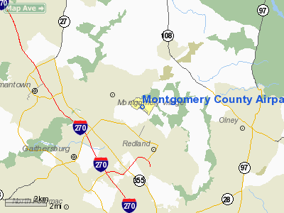
Gaithersburg, Maryland |
| Elevation AMSL |
539 ft / 164.3 m |
| Coordinates |
39°10′06″N 77°09′57.6″W / 39.16833°N 77.166°W / 39.16833; -77.166Coordinates: 39°10′06″N 77°09′57.6″W / 39.16833°N 77.166°W / 39.16833; -77.166 |
| Runways |
| Direction |
Length |
Surface |
| ft |
m |
| 14/32 |
4,202 |
1,281 |
Asphalt |
Montgomery County Airpark (IATA: GAI, ICAO: KGAI) is a public airport located three miles (5 km) northeast of the city of Gaithersburg, in Montgomery County, Maryland, USA. Facilities
Runways
Montgomery County Airpark covers 125 acres (51 ha) and has one runway.
- Runway 14/32: 4,202 x 75 ft. (1,281 x 23 m), Surface: Asphalt. (32 - right traffic)
Navigational aids
- WAAS/GPS/RNAV MDA 262 agl
- VOR 155 degree from FDK 109.0 MDA 600 agl
- NDB 385mg (on field) MDA ?
On-field services
- Montgomery Aviation, Ltd.
- Full-service FBO - 100LL JetA
- Freestate Aviation
- Aviation Facilities Corp.
- Charter Operators
- Open Air Charters - Part 135
- Flight Schools
- Montgomery Aviation, Ltd.
- Forsyth Aviation
- Open Air Flight Training
- Aircraft Sales
- Designated Pilot Examiner
- Food & Beverage
Flying clubs
- Octopus Flying Club
- Inn Flying Club
- TSS Flying Club
- Congressional Flying Club
The above content comes from Wikipedia and is published under free licenses – click here to read more.
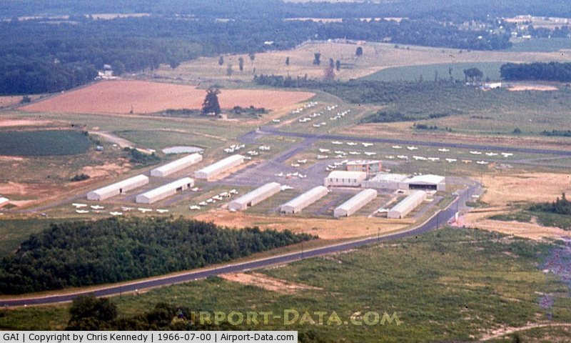
|
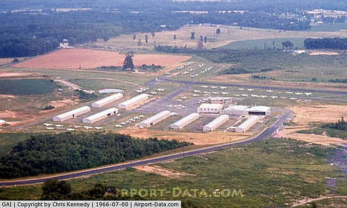 |
(Click on the photo to enlarge) |
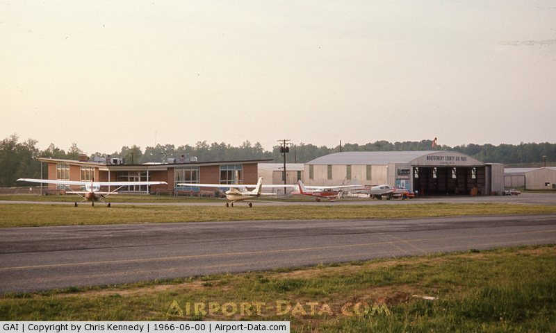
|
 |
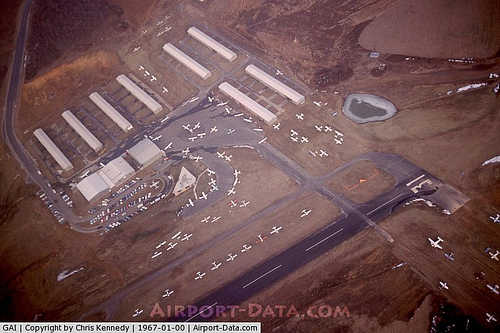
(Click on the photo to enlarge) |
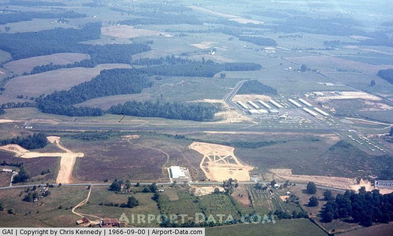
|
 |
(Click on the photo to enlarge) |
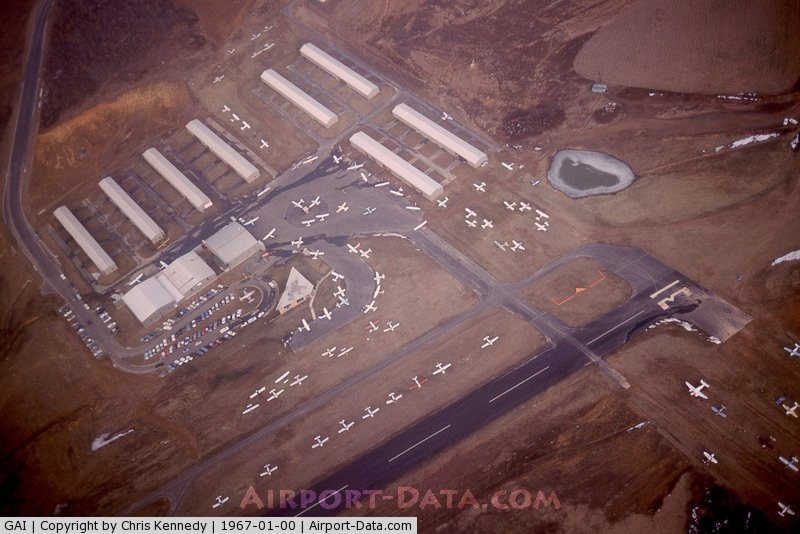
|
 |
(Click on the photo to enlarge) |
Location & QuickFacts
| FAA Information Effective: | 2008-09-25 |
| Airport Identifier: | GAI |
| Airport Status: | Operational |
| Longitude/Latitude: | 077-09-57.6000W/39-10-06.0000N
-77.166000/39.168333 (Estimated) |
| Elevation: | 539 ft / 164.29 m (Surveyed) |
| Land: | 125 acres |
| From nearest city: | 3 nautical miles NE of Gaithersburg, MD |
| Location: | Montgomery County, MD |
| Magnetic Variation: | 09W (1985) |
Owner & Manager
| Ownership: | Publicly owned |
| Owner: | Montgomery County Rev Auth |
| Address: | 101 Monroe St 4th Floor, Suite 410
Rockville, MD 20850 |
| Phone number: | 301-762-9080 |
| Manager: | John Luke Iii |
| Address: | 7940 Airpark Dr
Gaithersburg, MD 20879 |
| Phone number: | 301-963-7100 |
Airport Operations and Facilities
| Airport Use: | Open to public |
| Wind indicator: | No |
| Segmented Circle: | Yes |
| Control Tower: | No |
| Lighting Schedule: | DUSK-DAWN
ACTVT MIRL RY 14/32 & REIL RY 14/32 - CTAF |
| Beacon Color: | Clear-Green (lighted land airport) |
| Landing fee charge: | No |
| Sectional chart: | Washington |
| Region: | AEA - Eastern |
| Traffic Pattern Alt: | 1000 ft |
| Boundary ARTCC: | ZDC - Washington |
| Tie-in FSS: | DCA - Leesburg |
| FSS on Airport: | No |
| FSS Toll Free: | 1-800-WX-BRIEF |
| NOTAMs Facility: | DCA (NOTAM-d service avaliable) |
| Federal Agreements: | NGVY |
Airport Communications
| CTAF: | 123.075 |
| Unicom: | 123.075
FLT SCHOOL FREQ 123.3 |
Airport Services
| Fuel available: | 100LLA
FUEL AVBL 0800-2000; REQUEST ON 122.85. |
| Airframe Repair: | MAJOR |
| Power Plant Repair: | MAJOR |
| Bottled Oxygen: | LOW |
| Bulk Oxygen: | NONE |
Runway Information
Runway 14/32
| Dimension: | 4202 x 75 ft / 1280.8 x 22.9 m |
| Surface: | ASPH, Good Condition |
| Edge Lights: | Medium |
| |
Runway 14 |
Runway 32 |
| Longitude: | 077-10-18.8006W | 077-09-36.4145W |
| Latitude: | 39-10-18.6369N | 39-09-53.4181N |
| Elevation: | 493.00 ft | 539.00 ft |
| Alignment: | 127 | 127 |
| Traffic Pattern: | Left | Right |
| Markings: | Non-precision instrument, Good Condition | Non-precision instrument, Good Condition |
| VASI: | 4-box on left side | |
| Runway End Identifier: | Yes | Yes |
| Obstruction: | 15 ft trees, 410.0 ft from runway, 256 ft left of centerline, 13:1 slope to clear
RY 14 +10 FT TREES 145 FT R AT THLD. | 41 ft pole, 730.0 ft from runway, 280 ft right of centerline, 12:1 slope to clear
+15 FT RIDGE PARALLEL TO RY 155 FT L. |
|
Radio Navigation Aids
| ID |
Type |
Name |
Ch |
Freq |
Var |
Dist |
| GTN | NDB | Georgetown | | 323.00 | 09W | 14.5 nm |
| FND | NDB | Ellicott | | 371.00 | 11W | 19.5 nm |
| BUH | NDB | Anne Arundel | | 260.00 | 10W | 19.6 nm |
| DC | NDB | Oxonn | | 332.00 | 11W | 25.0 nm |
| IUB | NDB | Institute | | 404.00 | 08W | 26.2 nm |
| VKX | NDB | Potomac | | 241.00 | 10W | 27.1 nm |
| GDX | NDB | Goodwin Lake | | 227.00 | 08W | 33.6 nm |
| MTN | NDB | Martin | | 342.00 | 11W | 37.4 nm |
| TZ | NDB | Cogan | | 364.00 | 10W | 42.4 nm |
| EUD | NDB | York | | 254.00 | 11W | 47.1 nm |
| MTN | TACAN | Martin | 068X | | 11W | 36.5 nm |
| FDK | VOR | Frederick | | 109.00 | 08W | 17.6 nm |
| HGR | VOR | Hagerstown | | 109.80 | 07W | 45.1 nm |
| DCA | VOR/DME | Washington | 047X | 111.00 | 09W | 19.5 nm |
| PPM | VOR/DME | Phillips | 021X | 108.40 | 09W | 49.6 nm |
| AML | VORTAC | Armel | 082X | 113.50 | 08W | 19.9 nm |
| EMI | VORTAC | Westminster | 126X | 117.90 | 08W | 21.5 nm |
| BAL | VORTAC | Baltimore | 098X | 115.10 | 11W | 23.5 nm |
| ADW | VORTAC | Andrews | 078X | 113.10 | 10W | 25.8 nm |
| OTT | VORTAC | Nottingham | 084X | 113.70 | 10W | 34.1 nm |
| MRB | VORTAC | Martinsburg | 058X | 112.10 | 07W | 34.3 nm |
| CSN | VORTAC | Casanova | 110X | 116.30 | 06W | 45.5 nm |
| DCA | VOT | Washington National | | 109.40 | | 20.4 nm |
| ADW | VOT | Andrews Afb | | 109.60 | | 26.5 nm |
Remarks
- NOISE ABATEMENT DEP RY 32; TURN RIGHT TO AT LEAST 340 DEGS; JETS REFRAIN FROM RY 32 TAKEOFF BTWN 2300-0700.
- DEER & BIRDS ON & INVOF ARPT.
- HELICOPTERS REFRAIN FM AIR TAXI OVER PAVED PARKING RAMPS.
- 30 FT DOWNSLOPE 75 FT L/R OF CNTRLN AT THLD TO 150 FT BOTH SIDES.
- ARPT NOT RECOMMENDED FOR ACFT WITH WING SPAN IN EXCESS OF 79 FT & GROSS WT IN EXCESS OF 48,000 POUNDS.
- SOUTH RAMP NOT RECOMMENDED FOR AIRCRAFT W/ WINGSPAN GREATER THAN 79 FT OR WEIGHT GREATER THAN 40,000 LBS.
- BE ALERT ADIZ PROCEDURES IN EFFECT.
- PREFERRED CALM WIND RY 14.
Images and information placed above are from
http://www.airport-data.com/airport/GAI/
We thank them for the data!
| General Info
|
| Country |
United States
|
| State |
MARYLAND
|
| FAA ID |
GAI
|
| Latitude |
39-10-06.010N
|
| Longitude |
077-09-57.600W
|
| Elevation |
538 feet
|
| Near City |
GAITHERSBURG
|
We don't guarantee the information is fresh and accurate. The data may
be wrong or outdated.
For more up-to-date information please refer to other sources.
|
|