|
|
Coordinates: 38°36′02″N 077°04′23″W / 38.60056°N 77.07306°W / 38.60056; -77.07306
| Maryland Airport |
| IATA: none – ICAO: none – FAA LID: 2W5 |
| Summary |
| Airport type |
Public |
| Owner |
B. L. and J. K. Crawford |
| Serves |
Indian Head, Maryland |
| Elevation AMSL |
170 ft / 52 m |
| Runways |
| Direction |
Length |
Surface |
| ft |
m |
| 18/36 |
3,000 |
914 |
Asphalt |
| 2/20 |
1,860 |
567 |
Turf |
| Statistics (2007) |
| Aircraft operations |
18,050 |
| Source: Federal Aviation Administration |
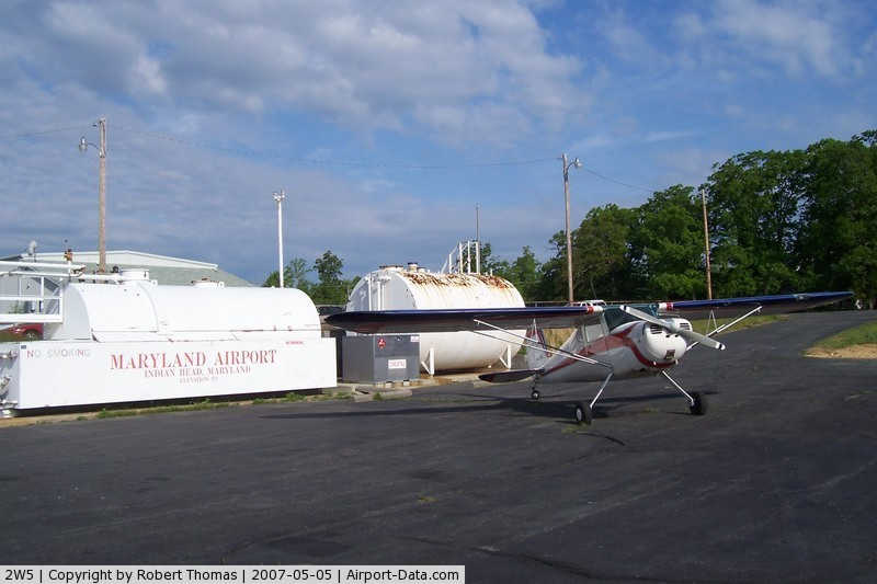
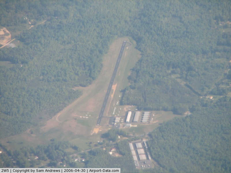
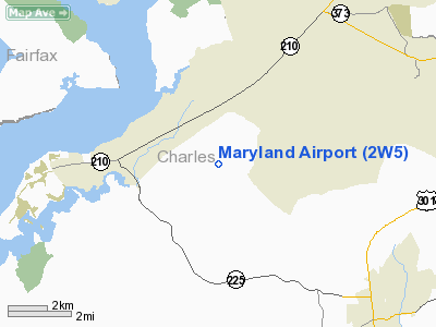
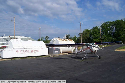
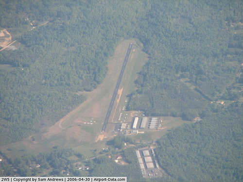
Maryland Airport (FAA LID: 2W5) is a privately-owned, public-use airport located four miles (6 km) east of the central business district of Indian Head, in Charles County, Maryland, United States. Facilities and aircraft
Maryland Airport covers an area of 377 acres (153 ha) which contains two runways: 18/36 with a 3,000 x 50 ft (914 x 15 m) asphalt pavement and 2/20 with a 1,860 x 100 ft (567 x 30 m) turf surface. For the 12-month period ending September 22, 2007, the airport had 18,050 aircraft operations, an average of 49 per day: 94% general aviation, 6% military and <1% air taxi.
The above content comes from Wikipedia and is published under free licenses – click here to read more.
|
 |
(Click on the photo to enlarge) |
|
 |
(Click on the photo to enlarge) |
Location & QuickFacts
| FAA Information Effective: | 2008-09-25 |
| Airport Identifier: | 2W5 |
| Airport Status: | Operational |
| Longitude/Latitude: | 077-04-22.6890W/38-36-01.9320N
-77.072969/38.600537 (Estimated) |
| Elevation: | 170 ft / 51.82 m (Surveyed) |
| Land: | 377 acres |
| From nearest city: | 4 nautical miles E of Indian Head, MD |
| Location: | Charles County, MD |
| Magnetic Variation: | 09W (1985) |
Owner & Manager
| Ownership: | Privately owned |
| Owner: | B L And J K Crawford |
| Address: | 3900 Livingston Rd
Indian Head, MD 20640 |
| Phone number: | 301-375-7606 |
| Manager: | John K Crawford |
| Address: | 3830 Livingston Rd
Indian Head, MD 20640 |
| Phone number: | 301-283-6202
OR 301-375-7337. |
Airport Operations and Facilities
| Airport Use: | Open to public |
| Wind indicator: | Yes |
| Segmented Circle: | No |
| Control Tower: | No |
| Lighting Schedule: | DUSK-2200
LIRL RY 18/36 AVBL AFT 2200 ON EMERG BASIS ONLY CALL 301-375-7606. |
| Landing fee charge: | No |
| Sectional chart: | Washington |
| Region: | AEA - Eastern |
| Traffic Pattern Alt: | 830 ft |
| Boundary ARTCC: | ZDC - Washington |
| Tie-in FSS: | DCA - Leesburg |
| FSS on Airport: | No |
| FSS Toll Free: | 1-800-WX-BRIEF |
| NOTAMs Facility: | DCA (NOTAM-d service avaliable) |
| Federal Agreements: | N |
Airport Communications
| CTAF: | 122.700 |
| Unicom: | 122.700 |
Airport Services
| Fuel available: | 100LLA |
| Airframe Repair: | MAJOR |
| Power Plant Repair: | MAJOR |
| Bottled Oxygen: | NONE |
| Bulk Oxygen: | NONE |
Runway Information
Runway 02/20
| Dimension: | 1860 x 100 ft / 566.9 x 30.5 m |
| Surface: | TURF, Good Condition |
| |
Runway 02 |
Runway 20 |
| Longitude: | 077-04-23.1410W | 077-04-19.8000W |
| Latitude: | 38-35-56.4820N | 38-36-14.6800N |
| Alignment: | 8 | 127 |
| Traffic Pattern: | Left | Left |
| Obstruction: | 19 ft trees, 378.0 ft from runway, 125 ft left of centerline, 19:1 slope to clear | 38 ft trees, 270.0 ft from runway, 125 ft left of centerline, 7:1 slope to clear |
|
Runway 18/36
| Dimension: | 3000 x 50 ft / 914.4 x 15.2 m |
| Surface: | ASPH, Good Condition |
| Edge Lights: | Low |
| |
Runway 18 |
Runway 36 |
| Longitude: | 077-04-27.5870W | 077-04-19.3000W |
| Latitude: | 38-36-14.1540N | 38-35-45.1880N |
| Elevation: | 170.00 ft | 156.00 ft |
| Alignment: | 127 | 127 |
| Traffic Pattern: | Left | Left |
| Markings: | Basic, Good Condition | Basic, Good Condition |
| Obstruction: | 61 ft trees, 579.0 ft from runway, 125 ft right of centerline, 6:1 slope to clear
RY 18 +10 FT DIRT MOUND 156 FT FM THLD 50 FT LEFT. | 12 ft trees, 225.0 ft from runway, 2:1 slope to clear |
|
Radio Navigation Aids
| ID |
Type |
Name |
Ch |
Freq |
Var |
Dist |
| DC | NDB | Oxonn | | 332.00 | 11W | 10.2 nm |
| VKX | NDB | Potomac | | 241.00 | 10W | 10.5 nm |
| GTN | NDB | Georgetown | | 323.00 | 09W | 19.9 nm |
| EZF | NDB | Shannon | | 237.00 | 10W | 26.8 nm |
| BUH | NDB | Anne Arundel | | 260.00 | 10W | 32.5 nm |
| APH | NDB | A P Hill | | 396.00 | 10W | 33.0 nm |
| GAI | NDB | Gaithersburg | | 385.00 | 09W | 34.5 nm |
| NHK | NDB | Patuxent | | 400.00 | 10W | 36.8 nm |
| CJR | NDB | Culpeper | | 252.00 | 09W | 37.1 nm |
| MSQ | NDB | Nailr | | 351.00 | 10W | 40.1 nm |
| GDX | NDB | Goodwin Lake | | 227.00 | 08W | 41.4 nm |
| FND | NDB | Ellicott | | 371.00 | 11W | 43.5 nm |
| IUB | NDB | Institute | | 404.00 | 08W | 46.3 nm |
| ESN | NDB | Easton | | 212.00 | 10W | 48.7 nm |
| CGE | NDB | Cambridge | | 355.00 | 10W | 49.1 nm |
| DCA | VOR/DME | Washington | 047X | 111.00 | 09W | 15.7 nm |
| ADW | VORTAC | Andrews | 078X | 113.10 | 10W | 15.8 nm |
| OTT | VORTAC | Nottingham | 084X | 113.70 | 10W | 16.7 nm |
| BRV | VORTAC | Brooke | 092X | 114.50 | 09W | 20.6 nm |
| AML | VORTAC | Armel | 082X | 113.50 | 08W | 27.3 nm |
| PXT | VORTAC | Patuxent | 123X | 117.60 | 10W | 36.8 nm |
| CSN | VORTAC | Casanova | 110X | 116.30 | 06W | 37.3 nm |
| BAL | VORTAC | Baltimore | 098X | 115.10 | 11W | 39.3 nm |
| ADW | VOT | Andrews Afb | | 109.60 | | 14.5 nm |
| DCA | VOT | Washington National | | 109.40 | | 14.8 nm |
Remarks
- ARPT CLSD NIGHTS.
- BIRDS & WILDLIFE ON & INVOF ARPT.
- RY 36 HAS 35 FT DROPOFF 100 FT; 0B.
- ESTAB PRIOR TO 1959.
Images and information placed above are from
http://www.airport-data.com/airport/2W5/
We thank them for the data!
| General Info
|
| Country |
United States
|
| State |
MARYLAND
|
| FAA ID |
2W5
|
| Latitude |
38-36-01.932N
|
| Longitude |
077-04-22.689W
|
| Elevation |
170 feet
|
| Near City |
INDIAN HEAD
|
We don't guarantee the information is fresh and accurate. The data may
be wrong or outdated.
For more up-to-date information please refer to other sources.
|
|