|
|
| Martin State Airport |
| IATA: MTN – ICAO: KMTN |
| Summary |
| Airport type |
Public |
| Operator |
Maryland Aviation Administration |
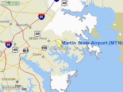
| Location |
Middle River, Maryland |
| Elevation AMSL |
22 ft / 6.7 m |
| Coordinates |
39°19′32.38″N 76°24′49.55″W / 39.3256611°N 76.4137639°W / 39.3256611; -76.4137639 |
| Runways |
| Direction |
Length |
Surface |
| ft |
m |
| 15/33 |
6,996 |
2,132 |
Concrete |
| Helipads |
| Number |
Length |
Surface |
| ft |
m |
| H1 |
65 |
20 |
Concrete |
Martin State Airport (IATA: MTN, ICAO: KMTN) is a joint civil-military public airport located near the town of Middle River, Maryland on Maryland State Highway 150 (Eastern Boulevard), near the intersection of Maryland State Highway 700 (Martin Boulevard), 9 miles (14 km) east of the city of Baltimore, in Baltimore County, Maryland, USA. The Maryland Aviation Administration operates the Airport on behalf of the Maryland Department of Transportation. MTN is a General Aviation Reliever Airport. The Maryland Air National Guard's 175th Wing is a tenant activity at MTN with locally-based A-10C and C-130J aircraft. The Air National Guard facility is located on the northwest side of the field and is officially named Warfield Air National Guard Base.
History
In 1929, Mr. Glenn L. Martin, a pioneer aviation designer and constructor, purchased 1,260 acres (5 km²) 12 miles (19 km) east of Baltimore for the purpose of creating an aircraft manufacturing site for the Glenn L. Martin Aircraft Company. One of the first aircraft produced at Martin was the B-10, in 1932, which brought the company of the Collier Trophy. Construction of three runways, Hangars 1-2-3, and the Airport Administration Building took place during 1939-1940. Hangars 4-5-6 and the Strawberry Point Hangar were completed in 1940-1941. The Pan Am China Clippers, PBM flying boats for the U.S. Navy, B-26 Marauder bombers for the U.S. Army Air Force and Martin Mars flying boats for the U.S. Navy were all produced in these facilities. During the post-World War II period, the Martin 202 and 404 commercial transports, as well as various jet-powered aircraft, were also produced. The Martin Company consolidated with the American Marietta Corporation in September 1961 to form the Martin Marietta Corporation. Since 1960, the field has also housed units of the Maryland Air National Guard. The land devoted to airfield use, namely 747 acres (3 km²), was sold on 20 September 1975, to the State of Maryland. In its role of fostering and developing aviation, the State’s purpose in purchasing the Airport was to ensure the retention of a General Aviation facility close to Baltimore.
The above content comes from Wikipedia and is published under free licenses – click here to read more.
|
 |
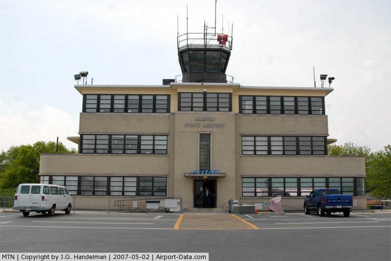
(Click on the photo to enlarge) |
Location & QuickFacts
| FAA Information Effective: | 2008-09-25 |
| Airport Identifier: | MTN |
| Airport Status: | Operational |
| Longitude/Latitude: | 076-24-49.6000W/39-19-32.4000N
-76.413778/39.325667 (Estimated) |
| Elevation: | 21 ft / 6.40 m (Surveyed) |
| Land: | 747 acres |
| From nearest city: | 9 nautical miles E of Baltimore, MD |
| Location: | Baltimore County, MD |
| Magnetic Variation: | 11W (2000) |
Owner & Manager
| Ownership: | Publicly owned |
| Owner: | Maa
MARYLAND AVIATION ADMINISTRATION. |
| Address: | Box 1 701 Wilson Pt Rd
Baltimore, MD 21220 |
| Phone number: | 410-682-8800 |
| Manager: | Alfred Pollard, A.a.e. |
| Address: | Box 1, 701 Wilson Point Rd
Baltimore, MD 21220 |
| Phone number: | 410-682-8800 |
Airport Operations and Facilities
| Airport Use: | Open to public |
| Wind indicator: | Yes |
| Segmented Circle: | No |
| Control Tower: | Yes |
| Lighting Schedule: | DUSK-DAWN
WHEN ATCT CLSD ACTVT HIRL RY 15/33; REIL RYS 15 & 33 - CTAF. WHEN ATCT CLSD ACTVT TWY F LGTS - UNICOM. |
| Beacon Color: | Clear-Green (lighted land airport) |
| Landing fee charge: | No |
| Sectional chart: | Washington |
| Region: | AEA - Eastern |
| Boundary ARTCC: | ZDC - Washington |
| Tie-in FSS: | DCA - Leesburg |
| FSS on Airport: | No |
| FSS Toll Free: | 1-800-WX-BRIEF |
| NOTAMs Facility: | MTN (NOTAM-d service avaliable) |
| Federal Agreements: | NGY |
Airport Communications
| CTAF: | 121.300 |
| Unicom: | 122.950 |
Airport Services
| Fuel available: | 100LLA |
| Airframe Repair: | MAJOR |
| Power Plant Repair: | MAJOR |
| Bottled Oxygen: | NONE |
| Bulk Oxygen: | HIGH/LOW |
Runway Information
Runway 15/33
| Dimension: | 6996 x 180 ft / 2132.4 x 54.9 m |
| Surface: | CONC, Good Condition |
| Weight Limit: | Single wheel: 65000 lbs.
Dual wheel: 82000 lbs.
Dual tandem wheel: 140000 lbs. |
| Edge Lights: | High |
| |
Runway 15 |
Runway 33 |
| Longitude: | 076-25-20.9370W | 076-24-18.1697W |
| Latitude: | 39-19-56.9037N | 39-19-07.8549N |
| Elevation: | 21.00 ft | 9.00 ft |
| Alignment: | 127 | 127 |
| ILS Type: | LOC/DME
| ILS/DME
|
| Traffic Pattern: | Left | Left |
| Markings: | Non-precision instrument, Good Condition | Precision instrument, Good Condition |
| Crossing Height: | 47.00 ft | 38.00 ft |
| VASI: | pulsating/steady burning on left side
PVASI RY 15 UNUSABLE BEYOND BYD 5 DEGREES LEFT AND RIGHT OF COURSE. | pulsating/steady burning on left side
PVASI RY 33 UNUSL BYD 5 DEG LEFT AND 8 DEG RIGHT OF COURSE. |
| Visual Glide Angle: | 4.01° | 2.91° |
| Runway End Identifier: | Yes | Yes |
| Obstruction: | 75 ft pline, 1665.0 ft from runway, 19:1 slope to clear | 39 ft trees, 2050.0 ft from runway, 450 ft right of centerline, 47:1 slope to clear |
|
Helipad H1
| Dimension: | 65 x 65 ft / 19.8 x 19.8 m |
| Surface: | CONC, Good Condition |
| |
Runway H1 |
Runway |
| Traffic Pattern: | Left | Left |
|
Radio Navigation Aids
| ID |
Type |
Name |
Ch |
Freq |
Var |
Dist |
| MTN | NDB | Martin | | 342.00 | 11W | 2.2 nm |
| IUB | NDB | Institute | | 404.00 | 08W | 10.1 nm |
| FND | NDB | Ellicott | | 371.00 | 11W | 17.1 nm |
| APG | NDB | Aberdeen | | 349.00 | 11W | 19.0 nm |
| BUH | NDB | Anne Arundel | | 260.00 | 10W | 21.7 nm |
| ESN | NDB | Easton | | 212.00 | 10W | 35.2 nm |
| GAI | NDB | Gaithersburg | | 385.00 | 09W | 36.2 nm |
| GTN | NDB | Georgetown | | 323.00 | 09W | 40.8 nm |
| EUD | NDB | York | | 254.00 | 11W | 41.7 nm |
| VKX | NDB | Potomac | | 241.00 | 10W | 42.9 nm |
| DC | NDB | Oxonn | | 332.00 | 11W | 44.2 nm |
| MTN | TACAN | Martin | 068X | | 11W | 0.3 nm |
| DOV | TACAN | Dover | 037X | | 09W | 45.6 nm |
| FDK | VOR | Frederick | | 109.00 | 08W | 45.0 nm |
| PPM | VOR/DME | Phillips | 021X | 108.40 | 09W | 14.1 nm |
| DCA | VOR/DME | Washington | 047X | 111.00 | 09W | 40.4 nm |
| BAL | VORTAC | Baltimore | 098X | 115.10 | 11W | 14.8 nm |
| EMI | VORTAC | Westminster | 126X | 117.90 | 08W | 28.1 nm |
| ADW | VORTAC | Andrews | 078X | 113.10 | 10W | 37.6 nm |
| OTT | VORTAC | Nottingham | 084X | 113.70 | 10W | 40.3 nm |
| ENO | VORTAC | Smyrna | 051X | 111.40 | 09W | 42.2 nm |
| DQO | VORTAC | Dupont | 087X | 114.00 | 10W | 43.0 nm |
| LRP | VORTAC | Lancaster | 120X | 117.30 | 09W | 48.1 nm |
| MXE | VORTAC | Modena | 079X | 113.20 | 09W | 49.5 nm |
| ADW | VOT | Andrews Afb | | 109.60 | | 39.0 nm |
| DCA | VOT | Washington National | | 109.40 | | 40.9 nm |
Remarks
- NOISE ABATEMENT PROCEDURES IN EFFECT. WHEN ATCT CLSD NO PRACTICE LNDGS OR APCHS.
- BEARING STRENGTH RY 15/33: ST175.
- RMK-ANG: FOR SPACE AVBL INFO, PLEASE CTC DSN 243-6551 C410-918-6551.
- SEAGULLS ON & INVOF ARPT.
- ARPT CONDS UNMONITORED 2300-0600.
- MOWING OPNS CONDUCTED 0830-1630 APR-SEP.
- PPR FOR PRACTICE TKOFS & LNDGS FOR ACFT WEIGHING MORE THAN 12500 LBS.
- RECREATIONAL SAILBOAT MASTS TO +50 FT & MOTOR BOATS IN WATERWAY AT AER 33 813 FT FM THLD 0B.
- FOR ADDL INFO CTC AMGR 410-682-8800.
Images and information placed above are from
http://www.airport-data.com/airport/MTN/
We thank them for the data!
| General Info
|
| Country |
United States
|
| State |
MARYLAND
|
| FAA ID |
MTN
|
| Latitude |
39-19-32.388N
|
| Longitude |
076-24-49.556W
|
| Elevation |
22 feet
|
| Near City |
BALTIMORE
|
We don't guarantee the information is fresh and accurate. The data may
be wrong or outdated.
For more up-to-date information please refer to other sources.
|
|