 |
|
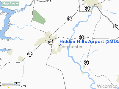
Location & QuickFacts
| FAA Information Effective: | 2008-09-25 |
| Airport Identifier: | 3MD5 |
| Airport Status: | Operational |
| Longitude/Latitude: | 075-50-28.7640W/38-37-16.4160N
-75.841323/38.621227 (Estimated) |
| Elevation: | 20 ft / 6.10 m (Estimated) |
| Land: | 10 acres |
| From nearest city: | 2 nautical miles NW of Hurlock, MD |
| Location: | Dorchester County, MD |
| Magnetic Variation: | 10W (1990) |
Owner & Manager
| Ownership: | Privately owned |
| Owner: | Philip Andrews |
| Address: | Po Box 909
Hurlock, MD 21643 |
| Phone number: | 410-943-4001 |
| Manager: | Paul Nuwer |
| Address: | Po Box 267
Hurlock, MD 21643 |
Airport Operations and Facilities
| Airport Use: | Private |
| Wind indicator: | Yes |
| Segmented Circle: | No |
| Control Tower: | No |
| Sectional chart: | Washington |
| Region: | AEA - Eastern |
| Boundary ARTCC: | ZDC - Washington |
| Tie-in FSS: | DCA - Leesburg |
| FSS on Airport: | No |
| FSS Toll Free: | 1-800-WX-BRIEF |
Runway Information
Runway 16/34
| Dimension: | 2500 x 75 ft / 762.0 x 22.9 m |
| Surface: | TURF, |
| |
Runway 16 |
Runway 34 |
| Traffic Pattern: | Left | Left |
|
Radio Navigation Aids
| ID |
Type |
Name |
Ch |
Freq |
Var |
Dist |
| CGE | NDB | Cambridge | | 355.00 | 10W | 10.3 nm |
| ESN | NDB | Easton | | 212.00 | 10W | 15.4 nm |
| NHK | NDB | Patuxent | | 400.00 | 10W | 33.2 nm |
| OX | NDB | Landy | | 407.00 | 12W | 34.0 nm |
| MTN | NDB | Martin | | 342.00 | 11W | 47.9 nm |
| DOV | TACAN | Dover | 037X | | 09W | 35.4 nm |
| ATR | VOR/DME | Waterloo | 073X | 112.60 | 09W | 31.6 nm |
| SBY | VORTAC | Salisbury | 049X | 111.20 | 12W | 22.8 nm |
| PXT | VORTAC | Patuxent | 123X | 117.60 | 10W | 33.1 nm |
| SWL | VORTAC | Snow Hill | 071X | 112.40 | 08W | 38.3 nm |
| ENO | VORTAC | Smyrna | 051X | 111.40 | 09W | 39.7 nm |
| OTT | VORTAC | Nottingham | 084X | 113.70 | 10W | 42.7 nm |
| ADW | VORTAC | Andrews | 078X | 113.10 | 10W | 49.4 nm |
| ADW | VOT | Andrews Afb | | 109.60 | | 49.7 nm |
Remarks
- OWNER DESIRES ARPT NOT BE CHARTED.
- PRVDD DALGT; VFR; PRIVATE USE.
Images and information placed above are from
http://www.airport-data.com/airport/3MD5/
We thank them for the data!
| General Info
|
| Country |
United States
|
| State |
MARYLAND
|
| FAA ID |
3MD5
|
| Latitude |
38-37-16.416N
|
| Longitude |
075-50-28.764W
|
| Elevation |
20 feet
|
| Near City |
HURLOCK
|
We don't guarantee the information is fresh and accurate. The data may
be wrong or outdated.
For more up-to-date information please refer to other sources.
|
|


