 |
|
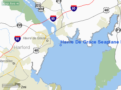
Havre De Grace Seaplane Base |
| Havre de Grace Seaplane Base |
| IATA: none – ICAO: none – FAA LID: M06 |
| Summary |
| Airport type |
Public |
| Owner |
Seaplane Base Development Group LLC |
| Serves |
Havre de Grace, Maryland |
| Elevation AMSL |
0 ft / 0 m |
| Coordinates |
39°33′02″N 076°05′19″W / 39.55056°N 76.08861°W / 39.55056; -76.08861 |
| Runways |
| Direction |
Length |
Surface |
| ft |
m |
| E/W |
8,000 |
2,438 |
Water |
| N/S |
8,000 |
2,438 |
Water |
| Statistics (2007) |
| Aircraft operations |
240 |
| Source: Federal Aviation Administration. Coordinates from WikiMapia |
Havre de Grace Seaplane Base (FAA LID: M06) is a privately-owned, public-use seaplane base located one nautical mile (2 km) east of the central business district of Havre de Grace, a city in Harford County, Maryland, United States. It is located on the west side of Chesapeake Bay.
Facilities and aircraft
Havre de Grace Seaplane Base covers an area of 2 acres (1 ha) and has two seaplane landing areas designated N/S and E/W, each measuring 8,000 x 200 ft (2,438 x 61 m). For the 12-month period ending March 19, 2007, the airport had 240 general aviation aircraft operations.
The above content comes from Wikipedia and is published under free licenses – click here to read more.
|
 |
(Click on the photo to enlarge) |
Location & QuickFacts
| FAA Information Effective: | 2008-09-25 |
| Airport Identifier: | M06 |
| Airport Status: | Operational |
| Longitude/Latitude: | 076-04-10.8180W/39-32-29.4080N
-76.069672/39.541502 (Estimated) |
| Elevation: | 0 ft / 0.00 m (Estimated) |
| Land: | 2 acres |
| From nearest city: | 1 nautical miles E of Havre De Grace, MD |
| Location: | Harford County, MD |
| Magnetic Variation: | 10W (1985) |
Owner & Manager
| Ownership: | Privately owned |
| Owner: | Seaplane Base Development Group Llc |
| Address: | 407 West Rosemary Lane
Falls Church, VA 22046 |
| Phone number: | 301-520-3245 |
| Manager: | Mr. Alexander Koning |
| Address: | 407 West Rosemary Lane
Falls Church, VA 22046 |
| Phone number: | 703-533-1936 |
Airport Operations and Facilities
| Airport Use: | Open to public |
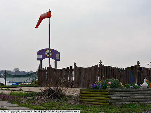
| Wind indicator: | Yes |
| Segmented Circle: | No |
| Control Tower: | No |
| Sectional chart: | Washington |
| Region: | AEA - Eastern |
| Boundary ARTCC: | ZDC - Washington |
| Responsible ARTCC: | ZNY - New York |
| Tie-in FSS: | DCA - Leesburg |
| FSS Toll Free: | 1-800-WX-BRIEF |
| NOTAMs Facility: | DCA (NOTAM-d service avaliable) |
Airport Communications
| CTAF: | 123.000 |
| Unicom: | 123.000 |
Airport Services
Runway Information
Runway E/W
| Dimension: | 8000 x 200 ft / 2438.4 x 61.0 m |
| Surface: | WATER, |
| |
Runway E |
Runway W |
| Traffic Pattern: | Left | Left |
|
Runway N/S
| Dimension: | 8000 x 200 ft / 2438.4 x 61.0 m |
| Surface: | WATER, |
| |
Runway N |
Runway S |
| Traffic Pattern: | Left | Left |
|
Radio Navigation Aids
| ID |
Type |
Name |
Ch |
Freq |
Var |
Dist |
| APG | NDB | Aberdeen | | 349.00 | 11W | 1.7 nm |
| MTN | NDB | Martin | | 342.00 | 11W | 20.5 nm |
| IUB | NDB | Institute | | 404.00 | 08W | 30.0 nm |
| FND | NDB | Ellicott | | 371.00 | 11W | 36.2 nm |
| BUH | NDB | Anne Arundel | | 260.00 | 10W | 42.3 nm |
| EUD | NDB | York | | 254.00 | 11W | 43.7 nm |
| RNB | NDB | Rainbow | | 363.00 | 11W | 44.0 nm |
| ESN | NDB | Easton | | 212.00 | 10W | 44.3 nm |
| MTN | TACAN | Martin | 068X | | 11W | 20.3 nm |
| DOV | TACAN | Dover | 037X | | 09W | 37.3 nm |
| PPM | VOR/DME | Phillips | 021X | 108.40 | 09W | 6.5 nm |
| DQO | VORTAC | Dupont | 087X | 114.00 | 10W | 22.9 nm |
| MXE | VORTAC | Modena | 079X | 113.20 | 09W | 29.2 nm |
| ENO | VORTAC | Smyrna | 051X | 111.40 | 09W | 31.8 nm |
| BAL | VORTAC | Baltimore | 098X | 115.10 | 11W | 35.4 nm |
| OOD | VORTAC | Woodstown | 075X | 112.80 | 10W | 36.0 nm |
| LRP | VORTAC | Lancaster | 120X | 117.30 | 09W | 36.2 nm |
| EMI | VORTAC | Westminster | 126X | 117.90 | 08W | 42.2 nm |
| PTW | VORTAC | Pottstown | 112X | 116.50 | 09W | 47.2 nm |
| PHL | VOT | Philadelphia Intl | | 109.80 | | 43.0 nm |
Remarks
- +100 FT BRIDGE APRXLY 3500 FT NORTH OF N/S RY.
- BIRDS ON & INVOF ARPT.
- MAJOR ULTRALGT REPAIRS & SVCS.
- MAY-NOV. FLOATING DOCK FULLY EXTENDED FOR LOCAL AND TRANSIENT ARCFT. STORAGE.
- COORDINATE THE USE OF THE WATERWAY WITH APPROPRIATE AGENCIES.
Images and information placed above are from
http://www.airport-data.com/airport/M06/
We thank them for the data!
| General Info
|
| Country |
United States
|
| State |
MARYLAND
|
| FAA ID |
M06
|
| Latitude |
39-32-29.408N
|
| Longitude |
076-04-10.818W
|
| Elevation |
0 feet
|
| Near City |
HAVRE DE GRACE
|
We don't guarantee the information is fresh and accurate. The data may
be wrong or outdated.
For more up-to-date information please refer to other sources.
|
|


