 |
|
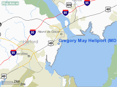
Location & QuickFacts
| FAA Information Effective: | 2008-09-25 |
| Airport Identifier: | MD08 |
| Airport Status: | Operational |
| Longitude/Latitude: | 076-06-12.9839W/39-31-56.0227N
-76.103607/39.532229 (Estimated) |
| Elevation: | 51 ft / 15.54 m (Estimated) |
| Land: | 0 acres |
| From nearest city: | 1 nautical miles SW of Havre De Grace, MD |
| Location: | Harford County, MD |
| Magnetic Variation: | 10W (1985) |
Owner & Manager
| Ownership: | Publicly owned |
| Owner: | Military Dept State Of Md |
| Address: | 5th Regiment Armory
Baltimore, MD 21201 |
| Phone number: | 410-436-4403 |
| Manager: | Director Of Aviation |
| Address: | Bldg E 4081
Apg, MD 21010 |
| Phone number: | 410-436-4403 |
Airport Operations and Facilities
| Airport Use: | Private
MEDICAL USE. |
| Wind indicator: | Yes |
| Segmented Circle: | No |
| Control Tower: | No |
| Lighting Schedule: | PHONE REQ |
| Sectional chart: | Washington |
| Region: | AEA - Eastern |
| Boundary ARTCC: | ZDC - Washington |
| Tie-in FSS: | DCA - Leesburg |
| FSS on Airport: | No |
| FSS Toll Free: | 1-800-WX-BRIEF |
Runway Information
Helipad H1
| Dimension: | 55 x 55 ft / 16.8 x 16.8 m |
| Surface: | CONC, |
| |
Runway H1 |
Runway |
| Traffic Pattern: | Left | Left |
|
Radio Navigation Aids
| ID |
Type |
Name |
Ch |
Freq |
Var |
Dist |
| APG | NDB | Aberdeen | | 349.00 | 11W | 0.2 nm |
| MTN | NDB | Martin | | 342.00 | 11W | 19.0 nm |
| IUB | NDB | Institute | | 404.00 | 08W | 28.4 nm |
| FND | NDB | Ellicott | | 371.00 | 11W | 34.6 nm |
| BUH | NDB | Anne Arundel | | 260.00 | 10W | 40.7 nm |
| EUD | NDB | York | | 254.00 | 11W | 42.7 nm |
| ESN | NDB | Easton | | 212.00 | 10W | 43.8 nm |
| RNB | NDB | Rainbow | | 363.00 | 11W | 45.5 nm |
| MTN | TACAN | Martin | 068X | | 11W | 18.7 nm |
| DOV | TACAN | Dover | 037X | | 09W | 38.1 nm |
| PPM | VOR/DME | Phillips | 021X | 108.40 | 09W | 5.0 nm |
| DQO | VORTAC | Dupont | 087X | 114.00 | 10W | 24.6 nm |
| MXE | VORTAC | Modena | 079X | 113.20 | 09W | 30.6 nm |
| ENO | VORTAC | Smyrna | 051X | 111.40 | 09W | 32.7 nm |
| BAL | VORTAC | Baltimore | 098X | 115.10 | 11W | 33.8 nm |
| LRP | VORTAC | Lancaster | 120X | 117.30 | 09W | 36.4 nm |
| OOD | VORTAC | Woodstown | 075X | 112.80 | 10W | 37.6 nm |
| EMI | VORTAC | Westminster | 126X | 117.90 | 08W | 40.6 nm |
| PTW | VORTAC | Pottstown | 112X | 116.50 | 09W | 48.5 nm |
| PHL | VOT | Philadelphia Intl | | 109.80 | | 44.6 nm |
Remarks
- 24/7 PHONE MARYLAND JOINT OPERATIONS CENTER 410-702-9000.
- PRVDD VFR ONLY.
Images and information placed above are from
http://www.airport-data.com/airport/MD08/
We thank them for the data!
| General Info
|
| Country |
United States
|
| State |
MARYLAND
|
| FAA ID |
MD08
|
| Latitude |
39-32-04.404N
|
| Longitude |
076-06-22.823W
|
| Elevation |
40 feet
|
| Near City |
HAVRE DE GRACE
|
We don't guarantee the information is fresh and accurate. The data may
be wrong or outdated.
For more up-to-date information please refer to other sources.
|
|


