 |
|
| Garrett County Airport |
| IATA: none – ICAO: none – FAA LID: 2G4 |
| Summary |
| Airport type |
Public |
| Operator |
Board of County Commissioners |
| Location |
Accident, Maryland |
| Elevation AMSL |
2,933 ft / 894 m |
| Coordinates |
39°34′49″N 079°20′22″W / 39.58028°N 79.33944°W / 39.58028; -79.33944Coordinates: 39°34′49″N 079°20′22″W / 39.58028°N 79.33944°W / 39.58028; -79.33944 |
| Runways |
| Direction |
Length |
Surface |
| ft |
m |
| 9/27 |
5,000 |
1,524 |
Asphalt |
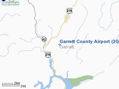
Garrett County Airport (FAA LID: 2G4) is a public airport located 13 miles (21 km) northeast of the central business district (CBD) of Oakland, a town in Garrett County, Maryland, USA.
Facilities
Garrett County Airport covers 200 acres (81 ha) and has one runway:
- Runway 9/27: 5,000 x 75 ft (1,524 x 23 m), Surface: Asphalt
The above content comes from Wikipedia and is published under free licenses – click here to read more.
Location & QuickFacts
| FAA Information Effective: | 2008-09-25 |
| Airport Identifier: | 2G4 |
| Airport Status: | Operational |
| Longitude/Latitude: | 079-20-09.3720W/39-34-50.9265N
-79.335937/39.580813 (Estimated) |
| Elevation: | 2933 ft / 893.98 m (Estimated) |
| Land: | 284 acres |
| From nearest city: | 13 nautical miles NE of Oakland, MD |
| Location: | Garrett County, MD |
| Magnetic Variation: | 09W (2010) |
Owner & Manager
| Ownership: | Publicly owned |
| Owner: | Board Of Co Commissioners |
| Address: | 313 East Alder Street, Room 105
Oakland, MD 21550
GENERAL SERVICE DEPT. C/O LAWRENCE DAWSON EXT.5047 |
| Phone number: | 301-334-1928 |
| Manager: | Mr. Edward B. Kelley |
| Address: | 771 Airport Road
Accident, MD 21520 |
| Phone number: | 301-387-4100
MANAGER EMER. # (301) 334-5047. |
Airport Operations and Facilities
| Airport Use: | Open to public |
| Wind indicator: | Yes |
| Segmented Circle: | Yes |
| Control Tower: | No |
| Lighting Schedule: | DUSK-DAWN
ACTVT MIRL RY 09/27 & PAPI RYS 09 & 27 - CTAF. |
| Beacon Color: | Clear-Green (lighted land airport) |
| Landing fee charge: | No |
| Sectional chart: | Cincinnati |
| Region: | AEA - Eastern |
| Traffic Pattern Alt: | 800 ft |
| Boundary ARTCC: | ZOB - Cleveland |
| Tie-in FSS: | EKN - Elkins |
| FSS on Airport: | No |
| FSS Toll Free: | 1-800-WX-BRIEF |
| NOTAMs Facility: | EKN (NOTAM-d service avaliable) |
| Federal Agreements: | N1 |
Airport Communications
| CTAF: | 123.000 |
| Unicom: | 123.000 |
Airport Services
| Fuel available: | 100LLA+ |
| Airframe Repair: | MINOR |
| Power Plant Repair: | MINOR |
| Bottled Oxygen: | NONE |
| Bulk Oxygen: | NONE |
Runway Information
Runway 09/27
| Dimension: | 5000 x 75 ft / 1524.0 x 22.9 m |
| Surface: | ASPH, |
| Surface Treatment: | Saw-cut or plastic Grooved |
| Edge Lights: | Medium |
| |
Runway 09 |
Runway 27 |
| Longitude: | 079-20-40.7030W | 079-19-38.0410W |
| Latitude: | 39-34-46.1870N | 39-34-55.6660N |
| Elevation: | 2933.00 ft | 2915.00 ft |
| Alignment: | 79 | 127 |
| Traffic Pattern: | Left | Left |
| Markings: | Non-precision instrument, Good Condition | Non-precision instrument, Good Condition |
| Crossing Height: | 44.00 ft | 45.00 ft |
| VASI: | 4-light PAPI on left side | 4-light PAPI on right side |
| Visual Glide Angle: | 3.00° | 3.00° |
| Runway End Identifier: | Yes | Yes |
| Obstruction: | 21 ft trees, 855.0 ft from runway, 31:1 slope to clear | 17 ft trees, 562.0 ft from runway, 140 ft right of centerline, 21:1 slope to clear |
|
Radio Navigation Aids
| ID |
Type |
Name |
Ch |
Freq |
Var |
Dist |
| VV | NDB | Camor | | 299.00 | 08W | 26.2 nm |
| CBE | NDB | Cumberland | | 317.00 | 07W | 27.6 nm |
| SYS | NDB | Stoystown | | 209.00 | 08W | 36.0 nm |
| BHU | NDB | Benje | | 382.00 | 07W | 47.9 nm |
| RQY | NDB | Randolph County | | 284.00 | 07W | 47.9 nm |
| GRV | VOR/DME | Grantsville | 070X | 112.30 | 06W | 13.6 nm |
| ESL | VOR/DME | Kessel | 045X | 110.80 | 06W | 26.7 nm |
| CKB | VOR/DME | Clarksburg | 073X | 112.60 | 04W | 47.5 nm |
| IHD | VORTAC | Indian Head | 019X | 108.20 | 06W | 23.7 nm |
| MGW | VORTAC | Morgantown | 053X | 111.60 | 05W | 24.3 nm |
| JST | VORTAC | Johnstown | 077X | 113.00 | 06W | 49.9 nm |
Remarks
- WILDLIFE ON AND INVOF ARPT.
Images and information placed above are from
http://www.airport-data.com/airport/2G4/
We thank them for the data!
| General Info
|
| Country |
United States
|
| State |
MARYLAND
|
| FAA ID |
2G4
|
| Latitude |
39-34-49.000N
|
| Longitude |
079-20-21.900W
|
| Elevation |
2933 feet
|
| Near City |
OAKLAND
|
We don't guarantee the information is fresh and accurate. The data may
be wrong or outdated.
For more up-to-date information please refer to other sources.
|
|


