 |
|
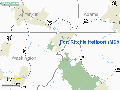
Location & QuickFacts
| FAA Information Effective: | 2008-09-25 |
| Airport Identifier: | MD98 |
| Airport Status: | Closed Permanently |
| Longitude/Latitude: | 077-29-58.9620W/39-42-00.3430N
-77.499712/39.700095 (Estimated) |
| Elevation: | 760 ft / 231.65 m (Estimated) |
| Land: | 0 acres |
| From nearest city: | 0 nautical miles of Fort Ritchie, MD |
| Location: | Baltimore County, MD |
| Magnetic Variation: | 09W (1985) |
Owner & Manager
| Ownership: | Army owned |
| Owner: | Military |
| Address: | Cmdr Hq Usag
Ft Ritchie, MD 21719-5010 |
| Manager: | Unknown |
| Address: |
|
Airport Operations and Facilities
| Airport Use: | Private |
| Segmented Circle: | No |
| Control Tower: | No |
| Sectional chart: | Washington |
| Region: | AEA - Eastern |
| Boundary ARTCC: | ZDC - Washington |
| Tie-in FSS: | DCA - Leesburg |
| FSS Toll Free: | 1-800-WX-BRIEF |
Runway Information
Helipad H1
| Dimension: | 50 x 50 ft / 15.2 x 15.2 m |
| Surface: | TURF, |
| |
Runway |
Runway |
| Traffic Pattern: | Left | Left |
|
Radio Navigation Aids
| ID |
Type |
Name |
Ch |
Freq |
Var |
Dist |
| EUD | NDB | York | | 254.00 | 11W | 31.6 nm |
| GAI | NDB | Gaithersburg | | 385.00 | 09W | 35.4 nm |
| FND | NDB | Ellicott | | 371.00 | 11W | 41.7 nm |
| TZ | NDB | Cogan | | 364.00 | 10W | 45.4 nm |
| GDX | NDB | Goodwin Lake | | 227.00 | 08W | 47.4 nm |
| IUB | NDB | Institute | | 404.00 | 08W | 47.6 nm |
| GTN | NDB | Georgetown | | 323.00 | 09W | 49.5 nm |
| HGR | VOR | Hagerstown | | 109.80 | 07W | 16.5 nm |
| FDK | VOR | Frederick | | 109.00 | 08W | 18.2 nm |
| MRB | VORTAC | Martinsburg | 058X | 112.10 | 07W | 24.9 nm |
| THS | VORTAC | St Thomas | 097X | 115.00 | 07W | 25.1 nm |
| EMI | VORTAC | Westminster | 126X | 117.90 | 08W | 27.1 nm |
| HAR | VORTAC | Harrisburg | 072X | 112.50 | 10W | 41.3 nm |
| AML | VORTAC | Armel | 082X | 113.50 | 08W | 46.0 nm |
| MDT | VOT | Harrisburg International | | 110.00 | | 45.2 nm |
Remarks
- (E137-1) PPR DUTY HOURS V277-5626.
- (E137-2) HELIPAD SUR BY BLDG, PLINE AND TREES.
- (E137-3) CIRCLE INSTALLATION WITH LDG LGT ON TO ALERT FIRE STN.
- (E137-3-1) MAKE APCH TO CNTR OF PARADE FLD (HELI LGT) AND HOVER TO EITHER SIDE TO DEBARK PSNGRS;IF SHUTTING DOWN PARK CNTR OF HELI TO AVOID GOLF COURSE FAIRWAYS.
- (E137-4) NO SVC AVBL.
- (ARPT STATUS) ARPT CLSD PERMLY.
Images and information placed above are from
http://www.airport-data.com/airport/MD98/
We thank them for the data!
| General Info
|
| Country |
United States
|
| State |
MARYLAND
|
| FAA ID |
MD98
|
| Latitude |
39-42-00.343N
|
| Longitude |
077-29-58.962W
|
| Elevation |
760 feet
|
| Near City |
FORT RITCHIE
|
We don't guarantee the information is fresh and accurate. The data may
be wrong or outdated.
For more up-to-date information please refer to other sources.
|
|


