 |
|
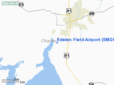
Location & QuickFacts
| FAA Information Effective: | 2008-09-25 |
| Airport Identifier: | 5MD8 |
| Airport Status: | Operational |
| Longitude/Latitude: | 077-00-41.9080W/38-29-27.4390N
-77.011641/38.490955 (Estimated) |
| Elevation: | 151 ft / 46.02 m (Estimated) |
| Land: | 50 acres |
| From nearest city: | 5 nautical miles SS of La Plata, MD |
| Location: | Charles County, MD |
| Magnetic Variation: | 10W (1990) |
Owner & Manager
| Ownership: | Privately owned |
| Owner: | Ed Edelen |
| Address: | Mulberry Grove
Port Tobacco, MD 20677 |
| Phone number: | 301-934-4000 |
| Manager: | Ed Edelen |
| Address: | Mulberry Grove
Port Tobacco, MD 20677 |
| Phone number: | 301-934-4000 |
Airport Operations and Facilities
| Airport Use: | Private |
| Wind indicator: | Yes |
| Segmented Circle: | No |
| Control Tower: | No |
| Sectional chart: | Washington |
| Region: | AEA - Eastern |
| Boundary ARTCC: | ZDC - Washington |
| Tie-in FSS: | DCA - Leesburg |
| FSS on Airport: | No |
| FSS Toll Free: | 1-800-WX-BRIEF |
Runway Information
Runway 02/20
| Dimension: | 2000 x 40 ft / 609.6 x 12.2 m |
| Surface: | TURF, |
| |
Runway 02 |
Runway 20 |
| Traffic Pattern: | Left | Left |
|
Radio Navigation Aids
| ID |
Type |
Name |
Ch |
Freq |
Var |
Dist |
| VKX | NDB | Potomac | | 241.00 | 10W | 15.7 nm |
| DC | NDB | Oxonn | | 332.00 | 11W | 16.6 nm |
| EZF | NDB | Shannon | | 237.00 | 10W | 24.7 nm |
| GTN | NDB | Georgetown | | 323.00 | 09W | 26.9 nm |
| APH | NDB | A P Hill | | 396.00 | 10W | 28.4 nm |
| NHK | NDB | Patuxent | | 400.00 | 10W | 31.2 nm |
| BUH | NDB | Anne Arundel | | 260.00 | 10W | 37.5 nm |
| CJR | NDB | Culpeper | | 252.00 | 09W | 39.9 nm |
| GAI | NDB | Gaithersburg | | 385.00 | 09W | 41.4 nm |
| MSQ | NDB | Nailr | | 351.00 | 10W | 42.1 nm |
| CGE | NDB | Cambridge | | 355.00 | 10W | 46.2 nm |
| GDX | NDB | Goodwin Lake | | 227.00 | 08W | 47.4 nm |
| ESN | NDB | Easton | | 212.00 | 10W | 48.1 nm |
| LJK | NDB | Ashey | | 280.00 | 09W | 48.5 nm |
| IQK | NDB | Louisa | | 382.00 | 09W | 49.0 nm |
| FND | NDB | Ellicott | | 371.00 | 11W | 49.1 nm |
| DCA | VOR/DME | Washington | 047X | 111.00 | 09W | 22.2 nm |
| OTT | VORTAC | Nottingham | 084X | 113.70 | 10W | 18.0 nm |
| BRV | VORTAC | Brooke | 092X | 114.50 | 09W | 18.6 nm |
| ADW | VORTAC | Andrews | 078X | 113.10 | 10W | 20.2 nm |
| PXT | VORTAC | Patuxent | 123X | 117.60 | 10W | 31.3 nm |
| AML | VORTAC | Armel | 082X | 113.50 | 08W | 34.2 nm |
| CSN | VORTAC | Casanova | 110X | 116.30 | 06W | 41.1 nm |
| BAL | VORTAC | Baltimore | 098X | 115.10 | 11W | 44.0 nm |
| ADW | VOT | Andrews Afb | | 109.60 | | 18.9 nm |
| DCA | VOT | Washington National | | 109.40 | | 21.3 nm |
Images and information placed above are from
http://www.airport-data.com/airport/5MD8/
We thank them for the data!
| General Info
|
| Country |
United States
|
| State |
MARYLAND
|
| FAA ID |
5MD8
|
| Latitude |
38-29-27.439N
|
| Longitude |
077-00-41.908W
|
| Elevation |
151 feet
|
| Near City |
LA PLATA
|
We don't guarantee the information is fresh and accurate. The data may
be wrong or outdated.
For more up-to-date information please refer to other sources.
|
|


