 |
|
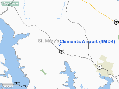
Location & QuickFacts
| FAA Information Effective: | 2008-09-25 |
| Airport Identifier: | 4MD4 |
| Airport Status: | Operational |
| Longitude/Latitude: | 076-44-14.0000W/38-20-26.0000N
-76.737222/38.340556 (Estimated) |
| Elevation: | 105 ft / 32.00 m (Estimated) |
| Land: | 200 acres |
| From nearest city: | 1 nautical miles NW of Clements, MD |
| Location: | St Marys County, MD |
| Magnetic Variation: | 10W (1990) |
Owner & Manager
| Ownership: | Privately owned |
| Owner: | Philip Hurry |
| Address: | Box 1 General Delivery
Clements, MD 20624 |
| Phone number: | 301-769-3643
OR DONALD JACKSON 301-863-5646. |
| Manager: | Philip Hurry |
| Address: | Box 1 General Delivery
Clements, MD 20624 |
| Phone number: | 301-769-3643 |
Airport Operations and Facilities
| Airport Use: | Private |
| Segmented Circle: | No |
| Control Tower: | No |
| Sectional chart: | Washington |
| Region: | AEA - Eastern |
| Boundary ARTCC: | ZDC - Washington |
| Tie-in FSS: | DCA - Leesburg |
| FSS on Airport: | No |
| FSS Toll Free: | 1-800-WX-BRIEF |
Runway Information
Runway 09/27
| Dimension: | 1750 x 80 ft / 533.4 x 24.4 m |
| Surface: | TURF, |
| |
Runway 09 |
Runway 27 |
| Traffic Pattern: | Left | Left |
|
Radio Navigation Aids
| ID |
Type |
Name |
Ch |
Freq |
Var |
Dist |
| NHK | NDB | Patuxent | | 400.00 | 10W | 16.1 nm |
| VKX | NDB | Potomac | | 241.00 | 10W | 26.6 nm |
| DC | NDB | Oxonn | | 332.00 | 11W | 29.0 nm |
| APH | NDB | A P Hill | | 396.00 | 10W | 31.6 nm |
| EZF | NDB | Shannon | | 237.00 | 10W | 34.0 nm |
| CGE | NDB | Cambridge | | 355.00 | 10W | 35.3 nm |
| GTN | NDB | Georgetown | | 323.00 | 09W | 39.8 nm |
| ESN | NDB | Easton | | 212.00 | 10W | 42.0 nm |
| BUH | NDB | Anne Arundel | | 260.00 | 10W | 44.7 nm |
| LJK | NDB | Ashey | | 280.00 | 09W | 49.0 nm |
| DCA | VOR/DME | Washington | 047X | 111.00 | 09W | 34.2 nm |
| PXT | VORTAC | Patuxent | 123X | 117.60 | 10W | 16.2 nm |
| OTT | VORTAC | Nottingham | 084X | 113.70 | 10W | 22.0 nm |
| ADW | VORTAC | Andrews | 078X | 113.10 | 10W | 28.7 nm |
| BRV | VORTAC | Brooke | 092X | 114.50 | 09W | 29.0 nm |
| AML | VORTAC | Armel | 082X | 113.50 | 08W | 49.5 nm |
| ADW | VOT | Andrews Afb | | 109.60 | | 27.7 nm |
| DCA | VOT | Washington National | | 109.40 | | 33.4 nm |
Remarks
- PRVDD ARPT IS USED FOR DALGT OPNS ONLY; IFR OPNS ARE NOT CONDUCTED; YOU EMPLOY SPEICAL EQUIP & PROCEDURES FOR OPERATING IN THIS AIRSPACE SINCE ARPT IS WITHIN THE WASHINGTON TCA.
Images and information placed above are from
http://www.airport-data.com/airport/4MD4/
We thank them for the data!
| General Info
|
| Country |
United States
|
| State |
MARYLAND
|
| FAA ID |
4MD4
|
| Latitude |
38-20-26.000N
|
| Longitude |
076-44-14.000W
|
| Elevation |
105 feet
|
| Near City |
CLEMENTS
|
We don't guarantee the information is fresh and accurate. The data may
be wrong or outdated.
For more up-to-date information please refer to other sources.
|
|


