|
|
Carroll County Rgnl / Jack B Poage Field Airport |
Carroll County Regional Airport
Jack B. Poage Field |
| IATA: none – ICAO: KDMW – FAA LID: DMW |
| Summary |
| Airport type |
Public |
| Owner |
Carroll County |
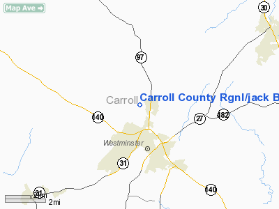
| Location |
Westminster, Maryland |
| Elevation AMSL |
789 ft / 240 m |
| Coordinates |
39°36′30″N 077°00′28″W / 39.60833°N 77.00778°W / 39.60833; -77.00778 |
| Website |
CarrollCountyAirport.com |
| Runways |
| Direction |
Length |
Surface |
| ft |
m |
| 16/34 |
5,100 |
1,554 |
Asphalt |
| Statistics (2006) |
| Aircraft operations |
153,690 |
| Based aircraft |
143 |
| Source: Federal Aviation Administration |
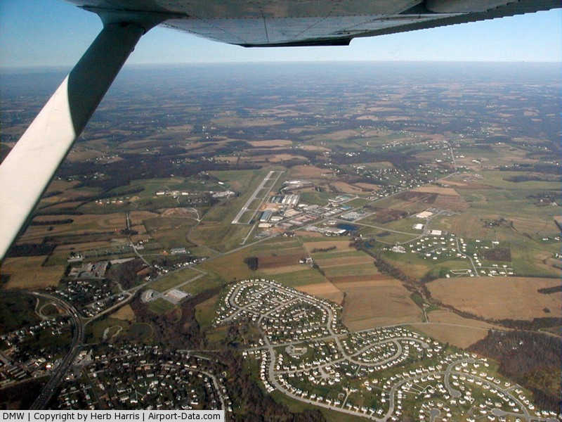
Carroll County Regional Airport (ICAO: KDMW, FAA LID: DMW), also known as Jack B. Poage Field, is a public airport located three miles (5 km) north of the central business district of Westminster, in Carroll County, Maryland, United States. The airport is owned by Carroll County Board of Commissioners. It is designated as a reliever airport for the Baltimore-Washington International Thurgood Marshall Airport (BWI).
Although most U.S. airports use the same three-letter location identifier for the FAA and IATA, Carroll County Regional Airport is assigned DMW by the FAA but has no designation from the IATA.
Facilities and aircraft
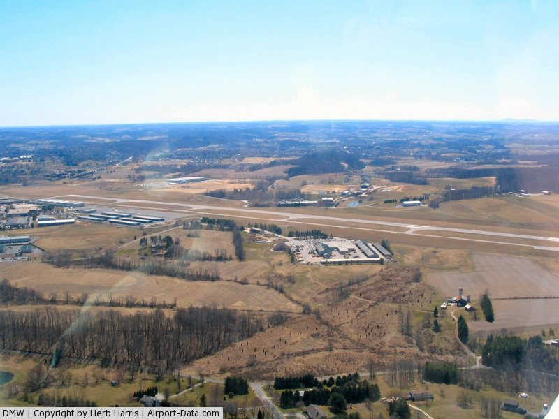
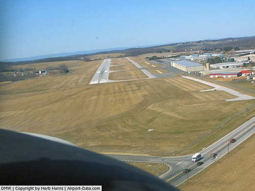
Carroll County Regional Airport covers an area of 135 acres (55 ha) which contains one asphalt paved runway (16/34) measuring 5,100 x 100 ft (1,554 x 30 m).
For the 12-month period ending May 2, 2006, the airport had 153,690 aircraft operations, an average of 421 per day: 99% general aviation, <1% air taxi and <1% military. There are 143 aircraft based at this airport: 85% single engine, 10% multi-engine, 4% jet aircraft and 1% helicopters.
There are currently no plans to bring commercial service to the airport. The nearest airport with commercial service is Baltimore BWI airport, serving flights to many US cities and with a few flights to/from Europe.
The above content comes from Wikipedia and is published under free licenses – click here to read more.
|
 |
(Click on the photo to enlarge) |
|
 |
(Click on the photo to enlarge) |
|
 |
(Click on the photo to enlarge) |
Location & QuickFacts
| FAA Information Effective: | 2008-09-25 |
| Airport Identifier: | DMW |
| Airport Status: | Operational |
| Longitude/Latitude: | 077-00-27.6000W/39-36-29.8000N
-77.007667/39.608278 (Estimated) |
| Elevation: | 789 ft / 240.49 m (Surveyed) |
| Land: | 135 acres |
| From nearest city: | 3 nautical miles N of Westminster, MD |
| Location: | Carroll County, MD |
| Magnetic Variation: | 11W (2000) |
Owner & Manager
| Ownership: | Publicly owned |
| Owner: | Carroll County Comm |
| Address: | 225 N Center St. Rm. 300
Westminster, MD 21157-5194 |
| Phone number: | 410-386-2044 |
| Manager: | Joseph D. Mckelvey |
| Address: | 200 Airport Drive, Box 8
Westminster, MD 21157 |
| Phone number: | 410-876-9885 |
Airport Operations and Facilities
| Airport Use: | Open to public |
| Wind indicator: | Yes |
| Segmented Circle: | Yes |
| Control Tower: | No |
| Lighting Schedule: | DUSK-DAWN
ACTVT MIRL RY 16/34; REIL RYS 16 & 34; TWY LGTS - CTAF. |
| Beacon Color: | Clear-Green (lighted land airport) |
| Landing fee charge: | No |
| Sectional chart: | Washington |
| Region: | AEA - Eastern |
| Boundary ARTCC: | ZNY - New York |
| Responsible ARTCC: | ZDC - Washington |
| Tie-in FSS: | DCA - Leesburg |
| FSS on Airport: | No |
| FSS Toll Free: | 1-800-WX-BRIEF |
| NOTAMs Facility: | DMW (NOTAM-d service avaliable) |
| Federal Agreements: | NGY |
Airport Communications
| CTAF: | 122.700 |
| Unicom: | 122.700 |
Airport Services
| Fuel available: | 100LLA |
| Airframe Repair: | MAJOR |
| Power Plant Repair: | MAJOR |
| Bottled Oxygen: | HIGH/LOW |
Runway Information
Runway 16/34
| Dimension: | 5100 x 100 ft / 1554.5 x 30.5 m |
| Surface: | ASPH, Good Condition |
| Surface Treatment: | Saw-cut or plastic Grooved |
| Weight Limit: | Single wheel: 22000 lbs. |
| Edge Lights: | Medium |
| |
Runway 16 |
Runway 34 |
| Longitude: | 077-00-44.8215W | 077-00-10.3137W |
| Latitude: | 39-36-51.1753N | 39-36-08.4192N |
| Elevation: | 789.00 ft | 774.00 ft |
| Alignment: | 127 | 127 |
| Traffic Pattern: | Left | Right |
| Markings: | Non-precision instrument, Good Condition | Non-precision instrument, Good Condition |
| Crossing Height: | 40.00 ft | 46.00 ft |
| VASI: | 2-light PAPI on left side | 2-light PAPI on left side |
| Visual Glide Angle: | 3.00° | 3.00° |
| Runway End Identifier: | Yes | Yes |
|
Radio Navigation Aids
| ID |
Type |
Name |
Ch |
Freq |
Var |
Dist |
| EUD | NDB | York | | 254.00 | 11W | 19.7 nm |
| FND | NDB | Ellicott | | 371.00 | 11W | 22.1 nm |
| IUB | NDB | Institute | | 404.00 | 08W | 26.2 nm |
| GAI | NDB | Gaithersburg | | 385.00 | 09W | 27.4 nm |
| BUH | NDB | Anne Arundel | | 260.00 | 10W | 33.5 nm |
| MTN | NDB | Martin | | 342.00 | 11W | 34.5 nm |
| GTN | NDB | Georgetown | | 323.00 | 09W | 41.1 nm |
| APG | NDB | Aberdeen | | 349.00 | 11W | 42.0 nm |
| MTN | TACAN | Martin | 068X | | 11W | 32.3 nm |
| FDK | VOR | Frederick | | 109.00 | 08W | 20.7 nm |
| HGR | VOR | Hagerstown | | 109.80 | 07W | 39.6 nm |
| PPM | VOR/DME | Phillips | 021X | 108.40 | 09W | 39.7 nm |
| DCA | VOR/DME | Washington | 047X | 111.00 | 09W | 45.0 nm |
| EMI | VORTAC | Westminster | 126X | 117.90 | 08W | 6.9 nm |
| BAL | VORTAC | Baltimore | 098X | 115.10 | 11W | 30.8 nm |
| MRB | VORTAC | Martinsburg | 058X | 112.10 | 07W | 41.2 nm |
| HAR | VORTAC | Harrisburg | 072X | 112.50 | 10W | 41.8 nm |
| LRP | VORTAC | Lancaster | 120X | 117.30 | 09W | 45.1 nm |
| AML | VORTAC | Armel | 082X | 113.50 | 08W | 45.8 nm |
| THS | VORTAC | St Thomas | 097X | 115.00 | 07W | 47.8 nm |
| ADW | VORTAC | Andrews | 078X | 113.10 | 10W | 48.6 nm |
| MDT | VOT | Harrisburg International | | 110.00 | | 37.2 nm |
| DCA | VOT | Washington National | | 109.40 | | 45.9 nm |
| ADW | VOT | Andrews Afb | | 109.60 | | 49.7 nm |
Remarks
- ARPT UNATNDD CHRISTMAS.
- GCO AVBL ON FREQ 121.725 THRU PCT CLEARANCE DELIVERY.
- WILDLIFE ON & INVOF ARPT.
Images and information placed above are from
http://www.airport-data.com/airport/DMW/
We thank them for the data!
| General Info
|
| Country |
United States
|
| State |
MARYLAND
|
| FAA ID |
DMW
|
| Latitude |
39-36-29.800N
|
| Longitude |
077-00-27.600W
|
| Elevation |
789 feet
|
| Near City |
WESTMINSTER
|
We don't guarantee the information is fresh and accurate. The data may
be wrong or outdated.
For more up-to-date information please refer to other sources.
|
|