 |
|
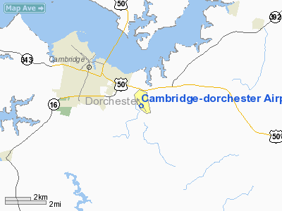
Cambridge-dorchester Airport |
| Cambridge-Dorchester Airport |
| IATA: CGE – ICAO: KCGE – FAA LID: CGE |
| Summary |
| Airport type |
Public |
| Owner |
Dorchester County Commissioners |
| Serves |
Cambridge, Maryland |
| Elevation AMSL |
20 ft / 6 m |
| Coordinates |
38°32′22″N 076°01′49″W / 38.53944°N 76.03028°W / 38.53944; -76.03028 |
| Runways |
| Direction |
Length |
Surface |
| ft |
m |
| 16/34 |
4,477 |
1,365 |
Asphalt |
| Statistics (2007) |
| Aircraft operations |
25,698 |
| Based aircraft |
49 |
| Source: Federal Aviation Administration |
Cambridge-Dorchester Airport (IATA: CGE, ICAO: KCGE, FAA LID: CGE) is a county-owned, public-use airport located three nautical miles (6 km) southeast of the central business district of Cambridge, in Dorchester County, Maryland, United States.
Facilities and aircraft
Cambridge-Dorchester Airport covers an area of 354 acres (143 ha) at an elevation of 20 feet (6 m) above mean sea level. It has one runway designated 16/34 with a 4,477 x 75 ft (1,365 x 23 m) asphalt surface.
For the 12-month period ending June 1, 2007, the airport had 25,698 aircraft operations, an average of 70 per day: 99% general aviation and 1% military. At that time there were 49 aircraft based at this airport: 80% single-engine, 6% multi-engine, 2% jet, 2% helicopter and 10% ultralight.
The above content comes from Wikipedia and is published under free licenses – click here to read more.
Location & QuickFacts
| FAA Information Effective: | 2008-09-25 |
| Airport Identifier: | CGE |
| Airport Status: | Operational |
| Longitude/Latitude: | 076-01-49.4000W/38-32-21.6000N
-76.030389/38.539333 (Estimated) |
| Elevation: | 20 ft / 6.10 m (Surveyed) |
| Land: | 354 acres |
| From nearest city: | 3 nautical miles SE of Cambridge, MD |
| Location: | Dorchester County, MD |
| Magnetic Variation: | 10W (1985) |
Owner & Manager
| Ownership: | Publicly owned |
| Owner: | Dorchester County Cmsnrs |
| Address: | 501 Court La
Cambridge, MD 21613 |
| Phone number: | 410-228-1700 |
| Manager: | Robert Tenanty |
| Address: | 5263 Bucktown Rd
Cambridge, MD 21613 |
| Phone number: | 410-228-4571 |
Airport Operations and Facilities
| Airport Use: | Open to public |
| Wind indicator: | Yes |
| Segmented Circle: | Yes |
| Control Tower: | No |
| Lighting Schedule: | DUSK-DAWN
ACTVT MIRL RY 16/34 & REIL & VASI RY 16 & 34 - 121.9. |
| Beacon Color: | Clear-Green (lighted land airport) |
| Landing fee charge: | No |
| Sectional chart: | Washington |
| Region: | AEA - Eastern |
| Boundary ARTCC: | ZDC - Washington |
| Tie-in FSS: | DCA - Leesburg |
| FSS Toll Free: | 1-800-WX-BRIEF |
| NOTAMs Facility: | DCA (NOTAM-d service avaliable) |
| Federal Agreements: | N |
Airport Communications
| CTAF: | 122.700 |
| Unicom: | 122.700 |
Airport Services
| Fuel available: | 100LLA |
| Airframe Repair: | MAJOR |
| Power Plant Repair: | MAJOR |
Runway Information
Runway 16/34
| Dimension: | 4477 x 75 ft / 1364.6 x 22.9 m |
| Surface: | ASPH, Good Condition |
| Surface Treatment: | Saw-cut or plastic Grooved |
| Weight Limit: | Single wheel: 14000 lbs. |
| Edge Lights: | Medium |
| |
Runway 16 |
Runway 34 |
| Longitude: | 076-02-06.0566W | 076-01-32.7916W |
| Latitude: | 38-32-39.4173N | 38-32-03.6951N |
| Elevation: | 18.00 ft | 16.00 ft |
| Alignment: | 127 | 127 |
| Traffic Pattern: | Left | Left |
| Markings: | Non-precision instrument, Good Condition | Non-precision instrument, Good Condition |
| Crossing Height: | 46.00 ft | 35.00 ft |
| VASI: | 2-light PAPI on left side | 2-light PAPI on left side |
| Visual Glide Angle: | 3.50° | 3.25° |
| Runway End Identifier: | Yes | Yes |
| Obstruction: | 72 ft trees, 1865.0 ft from runway, 98 ft right of centerline, 23:1 slope to clear | 19 ft pline, 360.0 ft from runway, 8:1 slope to clear |
|
Radio Navigation Aids
| ID |
Type |
Name |
Ch |
Freq |
Var |
Dist |
| ESN | NDB | Easton | | 212.00 | 10W | 16.1 nm |
| NHK | NDB | Patuxent | | 400.00 | 10W | 23.2 nm |
| OX | NDB | Landy | | 407.00 | 12W | 40.6 nm |
| VKX | NDB | Potomac | | 241.00 | 10W | 45.2 nm |
| BUH | NDB | Anne Arundel | | 260.00 | 10W | 47.3 nm |
| MTN | NDB | Martin | | 342.00 | 11W | 48.5 nm |
| DC | NDB | Oxonn | | 332.00 | 11W | 48.7 nm |
| DOV | TACAN | Dover | 037X | | 09W | 44.3 nm |
| ATR | VOR/DME | Waterloo | 073X | 112.60 | 09W | 41.7 nm |
| PXT | VORTAC | Patuxent | 123X | 117.60 | 10W | 23.1 nm |
| SBY | VORTAC | Salisbury | 049X | 111.20 | 12W | 27.1 nm |
| OTT | VORTAC | Nottingham | 084X | 113.70 | 10W | 35.0 nm |
| SWL | VORTAC | Snow Hill | 071X | 112.40 | 08W | 39.4 nm |
| ADW | VORTAC | Andrews | 078X | 113.10 | 10W | 42.4 nm |
| ENO | VORTAC | Smyrna | 051X | 111.40 | 09W | 48.1 nm |
| BAL | VORTAC | Baltimore | 098X | 115.10 | 11W | 48.1 nm |
| ADW | VOT | Andrews Afb | | 109.60 | | 42.6 nm |
Remarks
- BIRDS AND/OR WILDLIFE ON AND INVOF ARPT.
- UNLIMITED VEHICLE ACCESS TO ACFT MOVEMENT AREAS.
- EXISTED PRIOR TO 1959.
Images and information placed above are from
http://www.airport-data.com/airport/CGE/
We thank them for the data!
| General Info
|
| Country |
United States
|
| State |
MARYLAND
|
| FAA ID |
CGE
|
| Latitude |
38-32-21.500N
|
| Longitude |
076-01-49.300W
|
| Elevation |
19 feet
|
| Near City |
CAMBRIDGE
|
We don't guarantee the information is fresh and accurate. The data may
be wrong or outdated.
For more up-to-date information please refer to other sources.
|
|


