 |
|
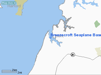
Breezecroft Seaplane Base |
Location & QuickFacts
| FAA Information Effective: | 2008-09-25 |
| Airport Identifier: | 23MD |
| Airport Status: | Operational |
| Longitude/Latitude: | 076-12-25.0000W/39-15-20.0000N
-76.206944/39.255556 (Estimated) |
| Elevation: | 10 ft / 3.05 m (Estimated) |
| Land: | 0 acres |
| From nearest city: | 8 nautical miles W of Chestertown, MD |
| Location: | Kent County, MD |
| Magnetic Variation: | 11W (2000) |
Owner & Manager
| Ownership: | Privately owned |
| Owner: | Frederick T. Lohr |
| Address: | 9860 Breezecroft Lane
Chestertown, MD 21620 |
| Phone number: | 410-778-1226 |
| Manager: | Frederick T. Lohr |
| Address: | 9860 Breezecroft Lane
Chestertown, MD 21620 |
| Phone number: | 410-778-1226 |
Airport Operations and Facilities
| Airport Use: | Private |
| Wind indicator: | Yes |
| Segmented Circle: | No |
| Control Tower: | No |
| Sectional chart: | Washington |
| Region: | AEA - Eastern |
| Boundary ARTCC: | ZDC - Washington |
| Tie-in FSS: | DCA - Leesburg |
| FSS Toll Free: | 1-800-WX-BRIEF |
Airport Communications
Runway Information
Runway 17W/35W
| Dimension: | 3000 x 100 ft / 914.4 x 30.5 m |
| Surface: | WATER, |
| |
Runway 17W |
Runway 35W |
| Traffic Pattern: | Left | Left |
|
Radio Navigation Aids
| ID |
Type |
Name |
Ch |
Freq |
Var |
Dist |
| MTN | NDB | Martin | | 342.00 | 11W | 8.5 nm |
| APG | NDB | Aberdeen | | 349.00 | 11W | 17.4 nm |
| IUB | NDB | Institute | | 404.00 | 08W | 19.6 nm |
| FND | NDB | Ellicott | | 371.00 | 11W | 26.6 nm |
| BUH | NDB | Anne Arundel | | 260.00 | 10W | 27.8 nm |
| ESN | NDB | Easton | | 212.00 | 10W | 27.8 nm |
| CGE | NDB | Cambridge | | 355.00 | 10W | 43.9 nm |
| GAI | NDB | Gaithersburg | | 385.00 | 09W | 45.0 nm |
| VKX | NDB | Potomac | | 241.00 | 10W | 46.4 nm |
| GTN | NDB | Georgetown | | 323.00 | 09W | 47.1 nm |
| DC | NDB | Oxonn | | 332.00 | 11W | 48.3 nm |
| MTN | TACAN | Martin | 068X | | 11W | 10.5 nm |
| DOV | TACAN | Dover | 037X | | 09W | 35.2 nm |
| PPM | VOR/DME | Phillips | 021X | 108.40 | 09W | 12.8 nm |
| DCA | VOR/DME | Washington | 047X | 111.00 | 09W | 45.5 nm |
| BAL | VORTAC | Baltimore | 098X | 115.10 | 11W | 21.8 nm |
| ENO | VORTAC | Smyrna | 051X | 111.40 | 09W | 32.2 nm |
| DQO | VORTAC | Dupont | 087X | 114.00 | 10W | 37.7 nm |
| EMI | VORTAC | Westminster | 126X | 117.90 | 08W | 38.6 nm |
| ADW | VORTAC | Andrews | 078X | 113.10 | 10W | 40.9 nm |
| OTT | VORTAC | Nottingham | 084X | 113.70 | 10W | 41.5 nm |
| MXE | VORTAC | Modena | 079X | 113.20 | 09W | 46.9 nm |
| OOD | VORTAC | Woodstown | 075X | 112.80 | 10W | 47.8 nm |
| ADW | VOT | Andrews Afb | | 109.60 | | 42.2 nm |
| DCA | VOT | Washington National | | 109.40 | | 45.8 nm |
Remarks
- PRVDD DALGT, VFR ONLY; COORDINATE LANDING AREA WITH APPROPRIATE AGENCIES WITH CONTROL/JURISDICTIONS OVER WATERWAYS; NEGOTIATE OPERATIONAL AGREEMENT WITH THESE AGENCIES; OPNS CONDUCTED TO MINIMIZE NOISE; AND COORDINATE ACTIVITIES WITH "POND VIEW" ARPT DURING SPB OPNS.
Images and information placed above are from
http://www.airport-data.com/airport/23MD/
We thank them for the data!
| General Info
|
| Country |
United States
|
| State |
MARYLAND
|
| FAA ID |
23MD
|
| Latitude |
39-15-20.000N
|
| Longitude |
076-12-25.000W
|
| Elevation |
10 feet
|
| Near City |
CHESTERTOWN
|
We don't guarantee the information is fresh and accurate. The data may
be wrong or outdated.
For more up-to-date information please refer to other sources.
|
|


