 |
|
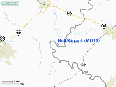
Location & QuickFacts
| FAA Information Effective: | 2008-09-25 |
| Airport Identifier: | MD12 |
| Airport Status: | Operational |
| Longitude/Latitude: | 077-17-34.0000W/39-38-11.0000N
-77.292778/39.636389 (Estimated) |
| Elevation: | 370 ft / 112.78 m (Estimated) |
| Land: | 102 acres |
| From nearest city: | 4 nautical miles S of Emmittsburg, MD |
| Location: | Frederick County, MD |
| Magnetic Variation: | 10W (1985) |
Owner & Manager
| Ownership: | Privately owned |
| Owner: | Earl S. Bell |
| Address: | Po Box 300
Emmitsburg, MD 21727 |
| Phone number: | 301-447-3646 |
| Manager: | Earl S. Bell |
| Address: | Po Box 300
Emmitsburg, MD 21727 |
| Phone number: | 301-447-3646 |
Airport Operations and Facilities
| Airport Use: | Private |
| Wind indicator: | Yes |
| Segmented Circle: | No |
| Control Tower: | No |
| Sectional chart: | Washington |
| Region: | AEA - Eastern |
| Boundary ARTCC: | ZNY - New York |
| Tie-in FSS: | DCA - Leesburg |
| FSS on Airport: | No |
| FSS Toll Free: | 1-800-WX-BRIEF |
Runway Information
Runway 02/20
| Dimension: | 2100 x 60 ft / 640.1 x 18.3 m |
| Surface: | TURF, |
| |
Runway 02 |
Runway 20 |
| Traffic Pattern: | Left | Left |
| Obstruction: | | 50 ft trees, 150.0 ft from runway |
|
Radio Navigation Aids
| ID |
Type |
Name |
Ch |
Freq |
Var |
Dist |
| EUD | NDB | York | | 254.00 | 11W | 25.7 nm |
| GAI | NDB | Gaithersburg | | 385.00 | 09W | 28.7 nm |
| FND | NDB | Ellicott | | 371.00 | 11W | 31.8 nm |
| IUB | NDB | Institute | | 404.00 | 08W | 37.4 nm |
| BUH | NDB | Anne Arundel | | 260.00 | 10W | 41.4 nm |
| GTN | NDB | Georgetown | | 323.00 | 09W | 43.2 nm |
| MTN | NDB | Martin | | 342.00 | 11W | 46.9 nm |
| GDX | NDB | Goodwin Lake | | 227.00 | 08W | 48.1 nm |
| TZ | NDB | Cogan | | 364.00 | 10W | 48.9 nm |
| MTN | TACAN | Martin | 068X | | 11W | 44.8 nm |
| FDK | VOR | Frederick | | 109.00 | 08W | 14.0 nm |
| HGR | VOR | Hagerstown | | 109.80 | 07W | 26.3 nm |
| DCA | VOR/DME | Washington | 047X | 111.00 | 09W | 48.2 nm |
| EMI | VORTAC | Westminster | 126X | 117.90 | 08W | 16.9 nm |
| MRB | VORTAC | Martinsburg | 058X | 112.10 | 07W | 29.9 nm |
| THS | VORTAC | St Thomas | 097X | 115.00 | 07W | 35.2 nm |
| BAL | VORTAC | Baltimore | 098X | 115.10 | 11W | 40.5 nm |
| HAR | VORTAC | Harrisburg | 072X | 112.50 | 10W | 41.3 nm |
| AML | VORTAC | Armel | 082X | 113.50 | 08W | 43.0 nm |
| MDT | VOT | Harrisburg International | | 110.00 | | 41.6 nm |
| DCA | VOT | Washington National | | 109.40 | | 49.1 nm |
Remarks
- PRVDD VFR USE ONLY; TREES N OF RY ARE REMOVED OR LOWERED OR THR DSPLCD FOR 20:1 CLNC.
Images and information placed above are from
http://www.airport-data.com/airport/MD12/
We thank them for the data!
| General Info
|
| Country |
United States
|
| State |
MARYLAND
|
| FAA ID |
MD12
|
| Latitude |
39-38-11.000N
|
| Longitude |
077-17-34.000W
|
| Elevation |
370 feet
|
| Near City |
EMMITTSBURG
|
We don't guarantee the information is fresh and accurate. The data may
be wrong or outdated.
For more up-to-date information please refer to other sources.
|
|


