|
|
| Bay Bridge Airport |
 |
| IATA: none – ICAO: none – FAA LID: W29 |
| Summary |
| Airport type |
Public |
| Owner |
Queen Anne's County |
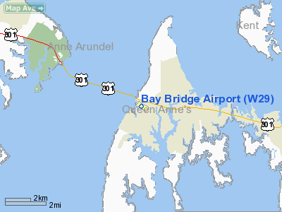
| Location |
Stevensville, Maryland |
| Elevation AMSL |
15 ft / 5 m |
| Coordinates |
38°58′35″N 076°19′47″W / 38.97639°N 76.32972°W / 38.97639; -76.32972 |
| Website |
www.baybridgeairport.net |
| Runways |
| Direction |
Length |
Surface |
| ft |
m |
| 11/29 |
2,903 |
885 |
Asphalt |
| Statistics (2007) |
| Aircraft operations |
46,000 |
| Based aircraft |
89 |
| Source: Federal Aviation Administration |
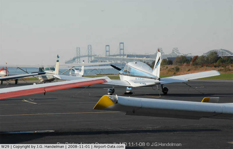
Bay Bridge Airport (FAA LID: W29) is a county-owned public-use airport located in Stevensville, Maryland. The airport is named for the nearby Chesapeake Bay Bridge and is mostly used for general aviation.
Bay Bridge Airport was home to Lynn Aviation, the personal company of famed aerobatic pilot Nancy Lynn. Facilities and aircraft
Bay Bridge Airport covers an area of 72 acres (29 ha) and contains one asphalt runway (11/29) measuring 2,903 x 60 ft (885 x 18 m). For the 12-month period ending July 15, 2007, the airport had 46,000 aircraft operations for an average of 126 per day: 99.6% general aviation and 0.4% air taxi. There are 89 aircraft based at this airport: 89% single-engine and 11% multi-engine.
Flight schools
The most prominent resident of Bay Bridge Airport is Trident Aircraft, a flight school that caters to all pilots. Trident Aircraft currently trains midshipmen from the nearby U.S. Naval Academy to prepare them for further training at the Pensacola Naval Air Station. The flight school employs multiple flight instructors and boasts a rental fleet of fixed-gear Cessna aircraft, a Piper Arrow, a twin-engine Beechcraft Duchess, a Super Decathlon for aerobatic and tailwheel training, and at least one Cirrus aircraft. Trident provides primary instruction through ATP, and is an authorized Cirrus training center.
Also operating out of Bay Bridge airport is Chesapeake Sport Pilot, which provides light sport instruction and light sport aircraft rental. The current fleet includes: Tecnam Sierra, Tecnam Eaglet, Tecnam Echo Super, and Sky Arrow aircraft.
The above content comes from Wikipedia and is published under free licenses – click here to read more.
|
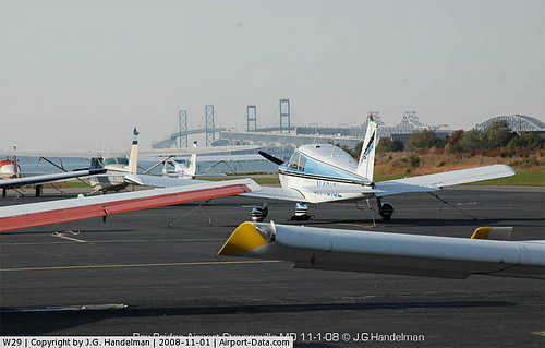 |
(Click on the photo to enlarge) |
Location & QuickFacts
| FAA Information Effective: | 2008-09-25 |
| Airport Identifier: | W29 |
| Airport Status: | Operational |
| Longitude/Latitude: | 076-19-46.7000W/38-58-35.0000N
-76.329639/38.976389 (Estimated) |
| Elevation: | 15 ft / 4.57 m (Estimated) |
| Land: | 72 acres |
| From nearest city: | 1 nautical miles W of Stevensville, MD |
| Location: | Queen Annes County, MD |
| Magnetic Variation: | 11W (2000) |
Owner & Manager
| Ownership: | Publicly owned |
| Owner: | Queen Anne County |
| Address: | 107 N Liberty St
Stevensville, MD 21617 |
| Phone number: | 410-798-4098 |
| Manager: | Jaime Giandomenico |
| Address: | 202 Airport Rd
Stevensville, MD 21666 |
| Phone number: | 410-643-4364 |
Airport Operations and Facilities
| Airport Use: | Open to public |
| Wind indicator: | Yes |
| Segmented Circle: | No |
| Control Tower: | No |
| Lighting Schedule: | DUSK-DAWN
ACTVT MIRL RY 11/29 & REIL RYS 11 & 29 - CTAF. |
| Beacon Color: | Clear-Green (lighted land airport) |
| Landing fee charge: | No
PRKG FEE |
| Sectional chart: | Washington |
| Region: | AEA - Eastern |
| Traffic Pattern Alt: | 1200 ft |
| Boundary ARTCC: | ZDC - Washington |
| Tie-in FSS: | DCA - Leesburg |
| FSS on Airport: | No |
| FSS Toll Free: | 1-800-WX-BRIEF |
| NOTAMs Facility: | W29 (NOTAM-d service avaliable) |
| Federal Agreements: | NGY |
Airport Communications
| CTAF: | 123.000 |
| Unicom: | 123.000 |
Airport Services
| Fuel available: | 100LLA |
| Airframe Repair: | MAJOR |
| Power Plant Repair: | MAJOR |
| Bottled Oxygen: | NONE |
| Bulk Oxygen: | NONE |
Runway Information
Runway 11/29
| Dimension: | 2903 x 60 ft / 884.8 x 18.3 m |
| Surface: | ASPH, Good Condition |
| Edge Lights: | Medium |
| |
Runway 11 |
Runway 29 |
| Longitude: | 076-20-04.6376W | 076-19-28.8046W |
| Latitude: | 38-58-38.2292N | 38-58-31.8462N |
| Elevation: | 5.00 ft | 15.00 ft |
| Alignment: | 103 | 127 |
| Traffic Pattern: | Left | Left |
| Markings: | Non-precision instrument, Fair Condition | Non-precision instrument, Fair Condition |
| Crossing Height: | 38.00 ft | 39.00 ft |
| Displaced threshold: | 0.00 ft | 190.00 ft |
| VASI: | 2-light PAPI on left side | 2-light PAPI on left side |
| Visual Glide Angle: | 3.00° | 3.00° |
| Runway End Identifier: | Yes | Yes |
| Obstruction: | , 50:1 slope to clear
RY 11 HAS +6 FT BRUSH 63 FT FM THLD 80 FT RIGHT. | 15 ft road, 200.0 ft from runway, 135 ft left of centerline
APCH SLOPE 30:1 TO DSPLCD THR.
+15 FT ROAD, 135 FT FM THLD 240 FT LEFT. |
|
Radio Navigation Aids
| ID |
Type |
Name |
Ch |
Freq |
Var |
Dist |
| ESN | NDB | Easton | | 212.00 | 10W | 16.0 nm |
| MTN | NDB | Martin | | 342.00 | 11W | 19.6 nm |
| BUH | NDB | Anne Arundel | | 260.00 | 10W | 21.1 nm |
| IUB | NDB | Institute | | 404.00 | 08W | 23.2 nm |
| FND | NDB | Ellicott | | 371.00 | 11W | 28.0 nm |
| CGE | NDB | Cambridge | | 355.00 | 10W | 29.8 nm |
| VKX | NDB | Potomac | | 241.00 | 10W | 32.4 nm |
| DC | NDB | Oxonn | | 332.00 | 11W | 35.0 nm |
| APG | NDB | Aberdeen | | 349.00 | 11W | 35.2 nm |
| GTN | NDB | Georgetown | | 323.00 | 09W | 37.2 nm |
| GAI | NDB | Gaithersburg | | 385.00 | 09W | 40.7 nm |
| NHK | NDB | Patuxent | | 400.00 | 10W | 41.6 nm |
| MTN | TACAN | Martin | 068X | | 11W | 21.6 nm |
| DOV | TACAN | Dover | 037X | | 09W | 41.3 nm |
| PPM | VOR/DME | Phillips | 021X | 108.40 | 09W | 30.4 nm |
| DCA | VOR/DME | Washington | 047X | 111.00 | 09W | 33.8 nm |
| BAL | VORTAC | Baltimore | 098X | 115.10 | 11W | 19.4 nm |
| OTT | VORTAC | Nottingham | 084X | 113.70 | 10W | 25.3 nm |
| ADW | VORTAC | Andrews | 078X | 113.10 | 10W | 27.1 nm |
| ENO | VORTAC | Smyrna | 051X | 111.40 | 09W | 40.9 nm |
| PXT | VORTAC | Patuxent | 123X | 117.60 | 10W | 41.5 nm |
| EMI | VORTAC | Westminster | 126X | 117.90 | 08W | 43.4 nm |
| ADW | VOT | Andrews Afb | | 109.60 | | 28.1 nm |
| DCA | VOT | Washington National | | 109.40 | | 33.9 nm |
Remarks
- TOUCH & GO OPERATIONS PROHIBITED.
- BIRDS ON & INVOF ARPT.
- NOISE ABATEMENT PROCEDURES IN EFFECT CTC AMGR 410-643-4364. NOISE SENSITIVE RESIDENTIAL AREA SOUTH OF ARPT; ENTER DOWNWIND FOR RY 29 OVER WATER TWR SOUTH OF FLD.
- VFR OPNS ONLY.
Images and information placed above are from
http://www.airport-data.com/airport/W29/
We thank them for the data!
| General Info
|
| Country |
United States
|
| State |
MARYLAND
|
| FAA ID |
W29
|
| Latitude |
38-58-35.000N
|
| Longitude |
076-19-46.700W
|
| Elevation |
15 feet
|
| Near City |
STEVENSVILLE
|
We don't guarantee the information is fresh and accurate. The data may
be wrong or outdated.
For more up-to-date information please refer to other sources.
|
|