 |
|
Sugarloaf Regional Airport |
| Sugarloaf Regional Airport |
| IATA: none – ICAO: none – FAA LID: B21 |
| Summary |
| Airport type |
Public |
| Owner |
Town of Carrabassett Valley |
| Serves |
Carrabassett Valley, Maine |
| Elevation AMSL |
885 ft / 270 m |
| Coordinates |
45°05′07.2″N 070°12′58.8″W / 45.085333°N 70.216333°W / 45.085333; -70.216333 |
| Runways |
| Direction |
Length |
Surface |
| ft |
m |
| 17/35 |
2,800 |
853 |
Asphalt |
| Statistics (2006) |
| Aircraft operations |
6,000 |
| Based aircraft |
11 |
| Source: Federal Aviation Administration |
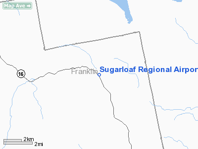
Sugarloaf Regional Airport is a public use airport in Franklin County, Maine, United States. It is owned by the Town of Carrabassett Valley and is located one nautical mile (1.85 km) north of the central business district.
Facilities and aircraft
Sugarloaf Regional Airport covers an area of 65 acres (26.3 ha) at an elevation of 885 feet (270 m) above mean sea level. It has one runway designated 17/35 with an asphalt surface measuring 2,800 by 75 feet (853 x 23 m).
For the 12-month period ending August 25, 2006, the airport had 6,000 aircraft operations, an average of 16 per day: 100% general aviation. At that time there were 11 aircraft based at this airport: 100% single-engine.
The above content comes from Wikipedia and is published under free licenses – click here to read more.
Location & QuickFacts
| FAA Information Effective: | 2008-09-25 |
| Airport Identifier: | B21 |
| Airport Status: | Operational |
| Longitude/Latitude: | 070-12-58.8000W/45-05-07.2000N
-70.216333/45.085333 (Estimated) |
| Elevation: | 885 ft / 269.75 m (Estimated) |
| Land: | 65 acres |
| From nearest city: | 1 nautical miles N of Carrabassett, ME |
| Location: | Franklin County, ME |
| Magnetic Variation: | 18W (1985) |
Owner & Manager
| Ownership: | Publicly owned |
| Owner: | Town Of Carrabassett |
| Address: | Town Office
Carrabasset, ME 04947 |
| Phone number: | 207-235-2646 |
| Manager: | Dave Cota |
| Address: | Rr #1, Box 2138
Carrabasset Valley, ME 04947 |
| Phone number: | 207-235-2646 |
Airport Operations and Facilities
| Airport Use: | Open to public |
| Wind indicator: | Yes |
| Segmented Circle: | Yes |
| Control Tower: | No |
| Landing fee charge: | No |
| Sectional chart: | Montreal |
| Region: | ANE - New England |
| Traffic Pattern Alt: | 2000 ft |
| Boundary ARTCC: | ZBW - Boston |
| Tie-in FSS: | BGR - Bangor |
| FSS on Airport: | No |
| FSS Toll Free: | 1-800-WX-BRIEF |
| NOTAMs Facility: | BGR (NOTAM-d service avaliable) |
| Federal Agreements: | NGY |
Airport Communications
| CTAF: | 122.800 |
| Unicom: | 122.800 |
Airport Services
| Airframe Repair: | NONE |
| Power Plant Repair: | NONE |
| Bottled Oxygen: | NONE |
| Bulk Oxygen: | NONE |
Runway Information
Runway 17/35
| Dimension: | 2800 x 75 ft / 853.4 x 22.9 m |
| Surface: | ASPH, Good Condition |
| Weight Limit: | Single wheel: 12000 lbs. |
| |
Runway 17 |
Runway 35 |
| Longitude: | 070-13-08.7000W | 070-12-48.9000W |
| Latitude: | 45-05-19.0900N | 45-04-55.2600N |
| Traffic Pattern: | Left | Left |
| Markings: | Basic, Good Condition | Basic, Good Condition |
| Obstruction: | 10 ft road, 200.0 ft from runway, 40 ft left of centerline
15-35 FOOT TREES, 0-200 FEET OUT, 90 FEET LEFT. 20-55 FOOT TREES, 0-50 FEET OUT, 60 FEET RIGHT. | 52 ft trees, 315.0 ft from runway, 130 ft left of centerline, 2:1 slope to clear
2-3 FOOT BRUSH, 180 FEET OUT BOTH SIDES OF CENTERLINE. 12 FOOT BRUSH, 50-200 FEET OUT, 85 FEET LEFT. |
|
Radio Navigation Aids
| ID |
Type |
Name |
Ch |
Freq |
Var |
Dist |
| RQM | NDB | Rangeley | | 221.00 | 18W | 24.5 nm |
| XQA | NDB | Squaw | | 236.00 | 18W | 34.8 nm |
| RL | NDB | Bracy | | 399.00 | 18W | 42.8 nm |
| BUP | NDB | Burnham | | 348.00 | 18W | 43.4 nm |
| AUG | VOR/DME | Augusta | 051X | 111.40 | 18W | 49.4 nm |
| BML | VOR/DME | Berlin | 041X | 110.40 | 17W | 49.4 nm |
Remarks
- HIGH TERRAIN 4237 FT MSL NORTH/EAST/WEST OF APRT.
- CALL 207-237-3200 TO CHECK ARPT CONDITIONS.
- RY 17/35 HAS 15-55 FT TREES PARALLEL TO RY; 75-90 FT LEFT & RIGHT OF CNTRLN.
- VFR OPNS ONLY.
Images and information placed above are from
http://www.airport-data.com/airport/B21/
We thank them for the data!
| General Info
|
| Country |
United States
|
| State |
MAINE
|
| FAA ID |
B21
|
| Latitude |
45-05-10.199N
|
| Longitude |
070-12-58.240W
|
| Elevation |
885 feet
|
| Near City |
CARRABASSETT
|
We don't guarantee the information is fresh and accurate. The data may
be wrong or outdated.
For more up-to-date information please refer to other sources.
|
|


