 |
|
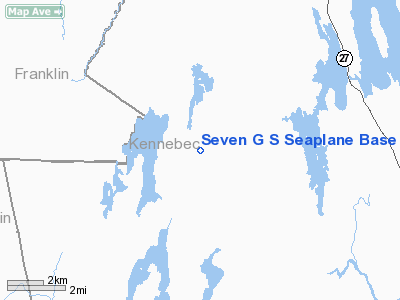
Location & QuickFacts
| FAA Information Effective: | 2008-09-25 |
| Airport Identifier: | 75B |
| Airport Status: | Operational |
| Longitude/Latitude: | 069-59-28.1970W/44-29-30.2340N
-69.991166/44.491732 (Estimated) |
| Elevation: | 329 ft / 100.28 m (Estimated) |
| Land: | 0 acres |
| From nearest city: | 1 nautical miles S of Mount Vernon, ME |
| Location: | Kennebec County, ME |
| Magnetic Variation: | 18W (1985) |
Owner & Manager
| Ownership: | Privately owned |
| Owner: | Garrit J. Gliniewicz |
| Address: | Belgrade Road
Mt. Vernon, ME 04352 |
| Phone number: | 207-293-2059 |
| Manager: | Garrit J. Gliniewicz |
| Address: | Belgrade Road
Mt. Vernon, ME 04352 |
| Phone number: | 207-293-2059 |
Airport Operations and Facilities
| Airport Use: | Open to public |
| Wind indicator: | No |
| Segmented Circle: | No |
| Control Tower: | No |
| Landing fee charge: | No |
| Sectional chart: | Montreal |
| Region: | ANE - New England |
| Boundary ARTCC: | ZBW - Boston |
| Tie-in FSS: | BGR - Bangor |
| FSS on Airport: | No |
| FSS Toll Free: | 1-800-WX-BRIEF |
| NOTAMs Facility: | BGR (NOTAM-d service avaliable) |
Airport Communications
Airport Services
| Airframe Repair: | NONE |
| Power Plant Repair: | NONE |
Runway Information
Runway 04/22
| Dimension: | 2500 x 200 ft / 762.0 x 61.0 m |
| Surface: | WATER, |
| |
Runway 04 |
Runway 22 |
| Traffic Pattern: | Left | Left |
| Obstruction: | 75 ft trees, 1239.0 ft from runway, 172 ft right of centerline, 16:1 slope to clear | 49 ft bldg, 980.0 ft from runway, 165 ft right of centerline, 20:1 slope to clear |
|
Radio Navigation Aids
| ID |
Type |
Name |
Ch |
Freq |
Var |
Dist |
| RL | NDB | Bracy | | 399.00 | 18W | 11.2 nm |
| BUP | NDB | Burnham | | 348.00 | 18W | 29.8 nm |
| ISS | NDB | Wiscasset | | 407.00 | 18W | 34.1 nm |
| RQM | NDB | Rangeley | | 221.00 | 18W | 42.0 nm |
| BST | NDB | Belfast | | 278.00 | 18W | 42.3 nm |
| SUH | NDB | Sprucehead | | 356.00 | 18W | 46.5 nm |
| SZO | NDB | Sebago | | 227.00 | 17W | 49.1 nm |
| NHZ | TACAN | Brunswick | 099X | | 17W | 37.3 nm |
| AUG | VOR/DME | Augusta | 051X | 111.40 | 18W | 13.3 nm |
Remarks
Images and information placed above are from
http://www.airport-data.com/airport/75B/
We thank them for the data!
| General Info
|
| Country |
United States
|
| State |
MAINE
|
| FAA ID |
75B
|
| Latitude |
44-29-30.234N
|
| Longitude |
069-59-28.197W
|
| Elevation |
329 feet
|
| Near City |
MOUNT VERNON
|
We don't guarantee the information is fresh and accurate. The data may
be wrong or outdated.
For more up-to-date information please refer to other sources.
|
|


