 |
|
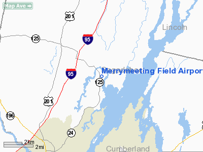
Merrymeeting Field Airport |
Location & QuickFacts
| FAA Information Effective: | 2008-09-25 |
| Airport Identifier: | 08B |
| Airport Status: | Operational |
| Longitude/Latitude: | 069-53-13.7000W/44-00-00.0000N
-69.887139/44.000000 (Estimated) |
| Elevation: | 65 ft / 19.81 m (Surveyed) |
| Land: | 0 acres |
| From nearest city: | 1 nautical miles SE of Bowdoinham, ME |
| Location: | Sagadahoc County, ME |
| Magnetic Variation: | 18W (1985) |
Owner & Manager
| Ownership: | Privately owned |
| Owner: | Mark Bowker |
| Address: | 108 Bay Road
Bowdoinham, ME 04008 |
| Phone number: | 508-340-3707 |
| Manager: | Mark Bowker |
| Address: | 108 Bay Road
Bowdoinham, ME 04008 |
| Phone number: | 603-964-7575 |
Airport Operations and Facilities
| Airport Use: | Open to public |
| Wind indicator: | Yes |
| Segmented Circle: | No |
| Control Tower: | No |
| Lighting Schedule: | DUSK-DAWN |
| Beacon Color: | Clear-Green (lighted land airport)
ROTG BCN OTS INDEFLY. |
| Landing fee charge: | No |
| Sectional chart: | Montreal |
| Region: | ANE - New England |
| Boundary ARTCC: | ZBW - Boston |
| Tie-in FSS: | BGR - Bangor |
| FSS on Airport: | No |
| FSS Toll Free: | 1-800-WX-BRIEF |
| NOTAMs Facility: | BGR (NOTAM-d service avaliable) |
Airport Communications
| CTAF: | 122.800 |
| Unicom: | 122.800 |
Airport Services
| Airframe Repair: | NONE |
| Power Plant Repair: | NONE |
| Bottled Oxygen: | NONE |
| Bulk Oxygen: | NONE |
Runway Information
Runway 14/32
| Dimension: | 1935 x 100 ft / 589.8 x 30.5 m |
| Surface: | TURF, Good Condition |
| Edge Lights: | Low
RY 14/32 LIRL OTS INDEFLY. |
| |
Runway 14 |
Runway 32 |
| Longitude: | 069-53-24.0056W | 069-53-03.3881W |
| Latitude: | 44-00-06.0174N | 43-59-54.0374N |
| Elevation: | 56.00 ft | 57.00 ft |
| Traffic Pattern: | Left | Left |
| Displaced threshold: | 417.00 ft
RY 14 DSPLCD THLD LGTS OTS INDEFLY. | 143.00 ft
RY 32 DSPLCD THLD LGTS OTS INDEFLY. |
| Obstruction: | 53 ft trees, 100.0 ft from runway, 50 ft right of centerline, 1:1 slope to clear
RWY 14 APCH RATIO 9:1 TO DSPLCD THLD. | 29 ft trees, 260.0 ft from runway, 8:1 slope to clear
RY 32 APCH SLOPE 13:1 TO DSPLCD THR. |
|
Radio Navigation Aids
| ID |
Type |
Name |
Ch |
Freq |
Var |
Dist |
| SZO | FAN MARKER | Grinn | | | 17W | 43.1 nm |
| PH | MARINE NDB | Portland Lhb-p | | 301.00 | 17W | 29.8 nm |
| ISS | NDB | Wiscasset | | 407.00 | 18W | 10.7 nm |
| RL | NDB | Bracy | | 399.00 | 18W | 28.4 nm |
| SUH | NDB | Sprucehead | | 356.00 | 18W | 33.9 nm |
| SZO | NDB | Sebago | | 227.00 | 17W | 39.2 nm |
| BST | NDB | Belfast | | 278.00 | 18W | 45.1 nm |
| BUP | NDB | Burnham | | 348.00 | 18W | 47.7 nm |
| NHZ | TACAN | Brunswick | 099X | | 17W | 7.8 nm |
| AUG | VOR/DME | Augusta | 051X | 111.40 | 18W | 19.6 nm |
| ENE | VORTAC | Kennebunk | 118X | 117.10 | 17W | 46.8 nm |
| PWM | VOT | Portland Intl Jetport | | 111.00 | | 28.5 nm |
Remarks
- TURF AREAS MAY BE SOFT.
- FROST HEAVE MID FIELD.
- VFR ONLY.
Images and information placed above are from
http://www.airport-data.com/airport/08B/
We thank them for the data!
| General Info
|
| Country |
United States
|
| State |
MAINE
|
| FAA ID |
08B
|
| Latitude |
44-00-00.000N
|
| Longitude |
069-53-13.700W
|
| Elevation |
65 feet
|
| Near City |
BOWDOINHAM
|
We don't guarantee the information is fresh and accurate. The data may
be wrong or outdated.
For more up-to-date information please refer to other sources.
|
|


