 |
|
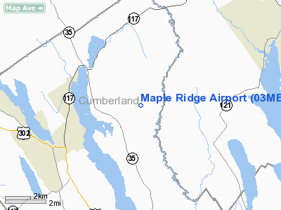
Location & QuickFacts
| FAA Information Effective: | 2008-09-25 |
| Airport Identifier: | 03ME |
| Airport Status: | Operational |
| Longitude/Latitude: | 070-37-38.2180W/44-05-03.2540N
-70.627283/44.084237 (Estimated) |
| Elevation: | 556 ft / 169.47 m (Surveyed) |
| Land: | 9 acres |
| From nearest city: | 3 nautical miles SE of Harrison, ME |
| Location: | Cumberland County, ME |
| Magnetic Variation: | 17W (1985) |
Owner & Manager
| Ownership: | Privately owned |
| Owner: | W. Locke Easton
ALTERNATE ADDRESS...67 PERKINS ROW, TOPSFIELD,MA 01983. |
| Address: | Box 202
Harrison, ME 04040 |
| Phone number: | 207-583-2271 |
| Manager: | W. Locke Easton |
| Address: | Box 202
Harrison, ME 04040 |
| Phone number: | 508-887-2862
OR CALL 207-583-2271/4169. |
Airport Operations and Facilities
| Airport Use: | Private |
| Wind indicator: | Yes |
| Segmented Circle: | No |
| Control Tower: | No |
| Landing fee charge: | Yes |
| Sectional chart: | Montreal |
| Region: | ANE - New England |
| Boundary ARTCC: | ZBW - Boston |
| Tie-in FSS: | BGR - Bangor |
| FSS on Airport: | No |
| FSS Toll Free: | 1-800-WX-BRIEF |
Airport Services
| Airframe Repair: | NONE |
| Power Plant Repair: | NONE |
Runway Information
Runway 18/36
| Dimension: | 2400 x 90 ft / 731.5 x 27.4 m |
| Surface: | TURF, |
| |
Runway 18 |
Runway 36 |
| Traffic Pattern: | Left | Left |
| Obstruction: | 35 ft pline, 30.0 ft from runway, 1:1 slope to clear | 50 ft trees, 500.0 ft from runway, 150 ft right of centerline, 10:1 slope to clear |
|
Radio Navigation Aids
| ID |
Type |
Name |
Ch |
Freq |
Var |
Dist |
| SZO | FAN MARKER | Grinn | | | 17W | 13.4 nm |
| HIE | FAN MARKER | Witey | | | 17W | 43.8 nm |
| LCI | FAN MARKER | Laconia | | | | 47.0 nm |
| PH | MARINE NDB | Portland Lhb-p | | 301.00 | 17W | 40.8 nm |
| SZO | NDB | Sebago | | 227.00 | 17W | 12.7 nm |
| HXK | NDB | Hornebrook | | 281.00 | 17W | 38.0 nm |
| ISS | NDB | Wiscasset | | 407.00 | 18W | 43.1 nm |
| RL | NDB | Bracy | | 399.00 | 18W | 44.6 nm |
| GMA | NDB | Mahn | | 386.00 | 17W | 48.6 nm |
| NHZ | TACAN | Brunswick | 099X | | 17W | 33.0 nm |
| AUG | VOR/DME | Augusta | 051X | 111.40 | 18W | 38.5 nm |
| BML | VOR/DME | Berlin | 041X | 110.40 | 17W | 40.8 nm |
| ENE | VORTAC | Kennebunk | 118X | 117.10 | 17W | 39.6 nm |
| PWM | VOT | Portland Intl Jetport | | 111.00 | | 29.8 nm |
Remarks
- LANDING AREA OUTLINED WITH YELLOW CONES.
- FILED FOR RECORD PURPOSES ONLY.
Images and information placed above are from
http://www.airport-data.com/airport/03ME/
We thank them for the data!
| General Info
|
| Country |
United States
|
| State |
MAINE
|
| FAA ID |
03ME
|
| Latitude |
44-05-03.254N
|
| Longitude |
070-37-38.218W
|
| Elevation |
556 feet
|
| Near City |
HARRISON
|
We don't guarantee the information is fresh and accurate. The data may
be wrong or outdated.
For more up-to-date information please refer to other sources.
|
|


