|
|
|
 |
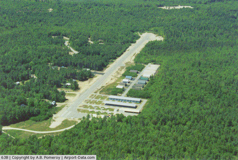
(Click on the photo to enlarge) |
Location & QuickFacts
| FAA Information Effective: | 2008-09-25 |
| Airport Identifier: | 63B |
| Airport Status: | Operational |
| Longitude/Latitude: | 070-40-20.9000W/43-45-46.9000N
-70.672472/43.763028 (Estimated) |
| Elevation: | 291 ft / 88.70 m (Surveyed) |
| Land: | 42 acres |
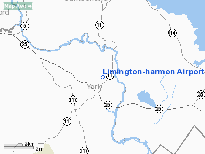
| From nearest city: | 3 nautical miles N of Limington, ME |
| Location: | York County, ME |
| Magnetic Variation: | 17W (1985) |
Owner & Manager
| Ownership: | Privately owned |
| Owner: | Limington Airport Authority, Llc |
| Address: | P.o. Box 483
Limington, ME 04049 |
| Phone number: | 207-637-2121 |
| Manager: | Andrew Pomeroy |
| Address: | P.o. Box 483
Limington, ME 04049 |
| Phone number: | 207-637-2121
EMERGENCY PHONE: 207-756-5782. |
Airport Operations and Facilities
| Airport Use: | Open to public |
| Wind indicator: | Yes |
| Segmented Circle: | No |
| Control Tower: | No |
| Lighting Schedule: | RDO-CTL
ACTVT LIRL RY 11/29 5 CLICKS - CTAF. |
| Landing fee charge: | No |
| Sectional chart: | New York |
| Region: | ANE - New England |
| Traffic Pattern Alt: | 1100 ft |
| Boundary ARTCC: | ZBW - Boston |
| Tie-in FSS: | BGR - Bangor |
| FSS on Airport: | No |
| FSS Toll Free: | 1-800-WX-BRIEF |
| NOTAMs Facility: | BGR (NOTAM-d service avaliable) |
Airport Communications
| CTAF: | 122.700 |
| Unicom: | 122.700 |
Airport Services
| Fuel available: | 100LL
24 HR. SELF-SERVE FUEL. |
| Airframe Repair: | MAJOR |
| Power Plant Repair: | MAJOR |
Runway Information
Runway 11/29
| Dimension: | 2973 x 50 ft / 906.2 x 15.2 m |
| Surface: | ASPH, Good Condition |
| Edge Lights: | Non-standard lighting system
NSTD LIRL. RY 29 - 2 THLD LGTS 260 FT FM THLD. RY 11 - 1 THLD LGT 300 FT FM THLD 10 FT LEFT. MANY LIGHTS MISSING. |
| |
Runway 11 |
Runway 29 |
| Longitude: | 070-40-41.1049W | 070-40-00.6509W |
| Latitude: | 43-45-47.6552N | 43-45-46.1615N |
| Elevation: | 292.00 ft | 279.00 ft |
| Traffic Pattern: | Left | Left |
| Markings: | Basic, Good Condition
RY 11/29 MARKED AS BASIC, THLD BARS ARE PRESENT BUT FADED. RY NRS ARE DSPLCD BY THE THLD BARS. | Basic, Good Condition |
| Obstruction: | 70 ft trees, 330.0 ft from runway, 140 ft left of centerline, 1:1 slope to clear
4-8 FT BRUSH; 200 FT RY END 0B. +3 FOOT BERM 50 FEET RIGHT 0-200' FROM THRESHOLD. | 35 ft trees, 305.0 ft from runway, 130 ft right of centerline, 3:1 slope to clear
+15 FOOT ROAD 50-200' FROM THRESHOLD 0-125 FEET RIGHT; +25 FOOT POLE 50 FEET FROM THRESHOLD 100 FEET RIGHT; +8-10 FOOT BRUSH 0-100 FEET FROM THRESHOLD 75 FEET RIGHT. |
|
Radio Navigation Aids
| ID |
Type |
Name |
Ch |
Freq |
Var |
Dist |
| SZO | FAN MARKER | Grinn | | | 17W | 14.8 nm |
| LCI | FAN MARKER | Laconia | | | | 35.4 nm |
| PH | MARINE NDB | Portland Lhb-p | | 301.00 | 17W | 29.0 nm |
| SZO | NDB | Sebago | | 227.00 | 17W | 9.7 nm |
| ESG | NDB | Rollins | | 260.00 | 16W | 33.3 nm |
| LC | NDB | Blnap | | 328.00 | 16W | 40.0 nm |
| ISS | NDB | Wiscasset | | 407.00 | 18W | 46.6 nm |
| NHZ | TACAN | Brunswick | 099X | | 17W | 33.2 nm |
| PSM | VOR/DME | Pease | 112X | 116.50 | 16W | 41.4 nm |
| ENE | VORTAC | Kennebunk | 118X | 117.10 | 17W | 20.4 nm |
| PWM | VOT | Portland Intl Jetport | | 111.00 | | 17.1 nm |
Remarks
Images and information placed above are from
http://www.airport-data.com/airport/63B/
We thank them for the data!
| General Info
|
| Country |
United States
|
| State |
MAINE
|
| FAA ID |
63B
|
| Latitude |
43-45-46.900N
|
| Longitude |
070-40-20.900W
|
| Elevation |
291 feet
|
| Near City |
LIMINGTON
|
We don't guarantee the information is fresh and accurate. The data may
be wrong or outdated.
For more up-to-date information please refer to other sources.
|
|