 |
|
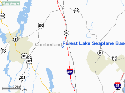
Forest Lake Seaplane Base |
Location & QuickFacts
| FAA Information Effective: | 2008-09-25 |
| Airport Identifier: | ME28 |
| Airport Status: | Operational |
| Longitude/Latitude: | 070-19-48.1900W/43-49-25.2800N
-70.330053/43.823689 (Estimated) |
| Elevation: | 274 ft / 83.52 m (Estimated) |
| Land: | 0 acres |
| From nearest city: | 4 nautical miles NW of Cumberland, ME |
| Location: | Cumberland County, ME |
| Magnetic Variation: | 17W (1995) |
Owner & Manager
| Ownership: | Privately owned |
| Owner: | Charles H Garland |
| Address: | 40 Forest Lake Road
Cumberland, ME 04021 |
| Phone number: | 207-829-6191 |
| Manager: | Charles H Garland |
| Address: | 40 Forest Lake Road
Cumberland, ME 04021 |
| Phone number: | 207-799-2294 |
Airport Operations and Facilities
| Airport Use: | Private |
| Segmented Circle: | No |
| Control Tower: | No |
| Sectional chart: | New York |
| Region: | ANE - New England |
| Boundary ARTCC: | ZBW - Boston |
| Tie-in FSS: | BGR - Bangor |
| FSS on Airport: | No |
| FSS Toll Free: | 1-800-WX-BRIEF |
Runway Information
Runway 04W/22W
| Dimension: | 5400 x 600 ft / 1645.9 x 182.9 m |
| Surface: | WATER, |
| |
Runway 04W |
Runway 22W |
| Traffic Pattern: | Left | Left |
|
Runway 09W/27W
| Dimension: | 3100 x 300 ft / 944.9 x 91.4 m |
| Surface: | WATER, |
| |
Runway 09W |
Runway 27W |
| Traffic Pattern: | Left | Left |
|
Runway 14W/32W
| Dimension: | 2850 x 200 ft / 868.7 x 61.0 m |
| Surface: | WATER, |
| |
Runway 14W |
Runway 32W |
| Traffic Pattern: | Left | Left |
|
Radio Navigation Aids
| ID |
Type |
Name |
Ch |
Freq |
Var |
Dist |
| SZO | FAN MARKER | Grinn | | | 17W | 25.2 nm |
| PH | MARINE NDB | Portland Lhb-p | | 301.00 | 17W | 20.6 nm |
| SZO | NDB | Sebago | | 227.00 | 17W | 20.2 nm |
| ISS | NDB | Wiscasset | | 407.00 | 18W | 31.4 nm |
| ESG | NDB | Rollins | | 260.00 | 16W | 42.3 nm |
| RL | NDB | Bracy | | 399.00 | 18W | 46.1 nm |
| NHZ | TACAN | Brunswick | 099X | | 17W | 17.9 nm |
| AUG | VOR/DME | Augusta | 051X | 111.40 | 18W | 37.7 nm |
| PSM | VOR/DME | Pease | 112X | 116.50 | 16W | 49.5 nm |
| ENE | VORTAC | Kennebunk | 118X | 117.10 | 17W | 26.9 nm |
| PWM | VOT | Portland Intl Jetport | | 111.00 | | 11.0 nm |
Remarks
- 904 FT RADIO TWR 2.5 MILES FM SPB BEARING 014 DEG.
- 464 FT RADIO TWR 1.5 MILES FM SPB BEARING 217 DEG.
- 314 FT RADIO TWR 0.9 MILES FM SPB BEARING 295 DEG.
- PRVDD VFR, DAYTIME OPNS ONLY.
Images and information placed above are from
http://www.airport-data.com/airport/ME28/
We thank them for the data!
| General Info
|
| Country |
United States
|
| State |
MAINE
|
| FAA ID |
ME28
|
| Latitude |
43-49-25.280N
|
| Longitude |
070-19-48.190W
|
| Elevation |
274 feet
|
| Near City |
CUMBERLAND
|
We don't guarantee the information is fresh and accurate. The data may
be wrong or outdated.
For more up-to-date information please refer to other sources.
|
|


