 |
|
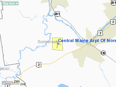
Central Maine Arpt Of Norridgewock Airport |
| Central Maine Airport of Norridgewock |
| IATA: OWK – ICAO: KOWK – FAA LID: OWK |
| Summary |
| Airport type |
Public |
| Owner |
Town of Norridgewock |
| Serves |
Norridgewock, Maine |
| Elevation AMSL |
270 ft / 82 m |
| Coordinates |
44°42′55.8″N 069°51′59.3″W / 44.7155°N 69.866472°W / 44.7155; -69.866472 |
| Runways |
| Direction |
Length |
Surface |
| ft |
m |
| 03/21 |
3,999 |
1,219 |
Asphalt |
| 15/33 |
3,999 |
1,219 |
Asphalt |
| Statistics (2006) |
| Aircraft operations |
9,824 |
| Based aircraft |
53 |
| Source: Federal Aviation Administration |
Central Maine Airport of Norridgewock (IATA: OWK, ICAO: KOWK, FAA LID: OWK) is a public use airport in Somerset County, Maine, United States. It is owned by the Town of Norridgewock and is located four nautical miles (7.4 km) west of the central business district.
Facilities and aircraft
Central Maine Airport of Norridgewock covers an area of 426 acres (172 ha) at an elevation of 270 feet (82 m) above mean sea level. It has two asphalt runways designated 03/21 and 15/33, both with surfaces measuring 3,999 by 90 feet (1,219 x 27 m).
For the 12-month period ending July 31, 2006, the airport had 9,824 aircraft operations, an average of 27 per day: 100% general aviation with a few military and ultralights. At that time there were 53 aircraft based at this airport: 84% single-engine, 8% multi-engine and 8% ultralights.
The above content comes from Wikipedia and is published under free licenses – click here to read more.
Location & QuickFacts
| FAA Information Effective: | 2008-09-25 |
| Airport Identifier: | OWK |
| Airport Status: | Operational |
| Longitude/Latitude: | 069-51-59.3000W/44-42-55.8000N
-69.866472/44.715500 (Estimated) |
| Elevation: | 270 ft / 82.30 m (Surveyed) |
| Land: | 426 acres |
| From nearest city: | 4 nautical miles W of Norridgewock, ME |
| Location: | Somerset County, ME |
| Magnetic Variation: | 18W (1985) |
Owner & Manager
| Ownership: | Publicly owned |
| Owner: | Town Of Norridgewock |
| Address: | Town Office
Norridgewock, ME 04957 |
| Phone number: | 207-634-2252 |
| Manager: | John Doucette |
| Address: | Town Office
Norridgewock, ME 04957 |
| Phone number: | 207-634-2252 |
Airport Operations and Facilities
| Airport Use: | Open to public |
| Wind indicator: | Yes |
| Segmented Circle: | Yes |
| Control Tower: | No |
| Lighting Schedule: | DUSK-DAWN
ACTVT MIRL RY 15/33 & REIL RY 33 - CTAF. |
| Beacon Color: | Clear-Green (lighted land airport) |
| Landing fee charge: | No |
| Sectional chart: | Montreal |
| Region: | ANE - New England |
| Boundary ARTCC: | ZBW - Boston |
| Tie-in FSS: | BGR - Bangor |
| FSS on Airport: | No |
| FSS Toll Free: | 1-800-WX-BRIEF |
| NOTAMs Facility: | BGR (NOTAM-d service avaliable) |
| Federal Agreements: | NG3 |
Airport Communications
| CTAF: | 122.800 |
| Unicom: | 122.800 |
Airport Services
| Fuel available: | 100LLMOGAS |
| Airframe Repair: | MAJOR |
| Power Plant Repair: | MAJOR |
| Bottled Oxygen: | NONE |
| Bulk Oxygen: | NONE |
Runway Information
Runway 03/21
| Dimension: | 3999 x 90 ft / 1218.9 x 27.4 m |
| Surface: | ASPH, Good Condition |
| Weight Limit: | Single wheel: 30000 lbs.
Dual wheel: 60000 lbs. |
| |
Runway 03 |
Runway 21 |
| Longitude: | 069-52-07.5059W | 069-51-58.2636W |
| Latitude: | 44-42-32.0578N | 44-43-10.9871N |
| Elevation: | 265.00 ft | 266.00 ft |
| Alignment: | 10 | 127 |
| Traffic Pattern: | Left | Left |
| Markings: | Non-precision instrument, Good Condition | Basic, Good Condition |
| Obstruction: | 57 ft trees, 593.0 ft from runway, 150 ft left of centerline, 6:1 slope to clear | 51 ft trees, 1290.0 ft from runway, 100 ft left of centerline, 21:1 slope to clear |
|
Runway 15/33
| Dimension: | 3999 x 90 ft / 1218.9 x 27.4 m |
| Surface: | ASPH, Good Condition |
| Weight Limit: | Single wheel: 30000 lbs.
Dual wheel: 60000 lbs. |
| Edge Lights: | Medium |
| |
Runway 15 |
Runway 33 |
| Longitude: | 069-52-16.9335W | 069-51-34.2920W |
| Latitude: | 44-43-12.6093N | 44-42-47.4182N |
| Elevation: | 264.00 ft | 258.00 ft |
| Alignment: | 127 | 127 |
| Traffic Pattern: | Left | Left |
| Markings: | Basic, Good Condition | Basic, Good Condition |
| Runway End Identifier: | | Yes |
| Obstruction: | 40 ft trees, 1000.0 ft from runway, 20:1 slope to clear | 18 ft trees, 222.0 ft from runway, 250 ft right of centerline, 1:1 slope to clear |
|
Radio Navigation Aids
| ID |
Type |
Name |
Ch |
Freq |
Var |
Dist |
| RL | NDB | Bracy | | 399.00 | 18W | 16.3 nm |
| BUP | NDB | Burnham | | 348.00 | 18W | 21.8 nm |
| RQM | NDB | Rangeley | | 221.00 | 18W | 39.9 nm |
| BST | NDB | Belfast | | 278.00 | 18W | 41.0 nm |
| ISS | NDB | Wiscasset | | 407.00 | 18W | 45.1 nm |
| XQA | NDB | Squaw | | 236.00 | 18W | 49.1 nm |
| AUG | VOR/DME | Augusta | 051X | 111.40 | 18W | 24.0 nm |
| BGR | VORTAC | Bangor | 095X | 114.80 | 19W | 43.0 nm |
| BGR | VOT | Bangor | | 111.00 | | 45.4 nm |
Remarks
- BIRDS AND DEER ON & INVOF ARPT.
- RY 15 HAS 30 FT DROPOFF 100 FT FM EOR.
- RY 21 HAS 30 FT DROPOFF 100 FT FM EOR.
- RY 03 HAS 30 FT DROPOFF 94 FT FM EOR.
- EXISTED PRIOR TO 1959.
Images and information placed above are from
http://www.airport-data.com/airport/OWK/
We thank them for the data!
| General Info
|
| Country |
United States
|
| State |
MAINE
|
| FAA ID |
OWK
|
| Latitude |
44-42-55.800N
|
| Longitude |
069-51-59.300W
|
| Elevation |
270 feet
|
| Near City |
NORRIDGEWOCK
|
We don't guarantee the information is fresh and accurate. The data may
be wrong or outdated.
For more up-to-date information please refer to other sources.
|
|


