 |
|
Caribou Municipal Airport |
| Caribou Municipal Airport |
| IATA: CAR – ICAO: KCAR |
| Summary |
| Airport type |
Public |
| Operator |
City of Caribou |
| Location |
Caribou, Maine |
| Elevation AMSL |
626 ft / 190.8 m |
| Coordinates |
46°52′17.4″N 68°01′04.5″W / 46.8715°N 68.017917°W / 46.8715; -68.017917Coordinates: 46°52′17.4″N 68°01′04.5″W / 46.8715°N 68.017917°W / 46.8715; -68.017917 |
| Runways |
| Direction |
Length |
Surface |
| ft |
m |
| 1/19 |
4,003 |
1,220 |
Asphalt |
| 11/29 |
3,017 |
920 |
Asphalt |
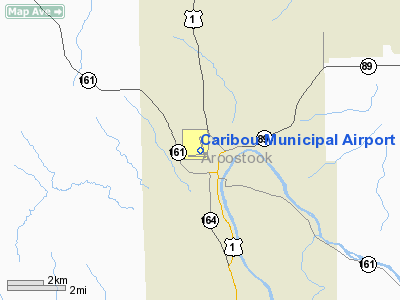
Caribou Municipal Airport (IATA: CAR, ICAO: KCAR) is a general aviation airport located 1 mile (2 km) northwest of the city of Caribou in Aroostook County, Maine, USA.
Facilities
Caribou Municipal Airport covers 75 acres (300,000 m) and has two runways:
- Runway 1/19: 4,003 x 100 ft (1,220 x 30 m), Surface: Asphalt
- Runway 11/29: 3,017 x 75 ft (920 x 23 m), Surface: Asphalt
The above content comes from Wikipedia and is published under free licenses – click here to read more.
Location & QuickFacts
| FAA Information Effective: | 2008-09-25 |
| Airport Identifier: | CAR |
| Airport Status: | Operational |
| Longitude/Latitude: | 068-01-04.5000W/46-52-17.4000N
-68.017917/46.871500 (Estimated) |
| Elevation: | 626 ft / 190.80 m (Surveyed) |
| Land: | 75 acres |
| From nearest city: | 1 nautical miles NW of Caribou, ME |
| Location: | Aroostook County, ME |
| Magnetic Variation: | 20W (2000) |
Owner & Manager
| Ownership: | Publicly owned |
| Owner: | City Of Caribou |
| Address: | 25 High Street
Caribou, ME 04736 |
| Phone number: | 207-493-3324 |
| Manager: | Steven Buck |
| Address: | 25 Main Street
Caribou, ME 04736 |
| Phone number: | 207-493-3324
EXT. 230. |
Airport Operations and Facilities
| Airport Use: | Open to public |
| Wind indicator: | Yes |
| Segmented Circle: | Yes |
| Control Tower: | No |
| Lighting Schedule: | DUSK-DAWN
ACTVT MIRL RYS 01/19 & 11/29 - CTAF. |
| Beacon Color: | Clear-Green (lighted land airport) |
| Landing fee charge: | No |
| Sectional chart: | Halifax |
| Region: | ANE - New England |
| Boundary ARTCC: | ZBW - Boston |
| Tie-in FSS: | BGR - Bangor |
| FSS on Airport: | No |
| FSS Toll Free: | 1-800-WX-BRIEF |
| NOTAMs Facility: | CAR (NOTAM-d service avaliable) |
| Federal Agreements: | NGY |
Airport Communications
| CTAF: | 122.800 |
| Unicom: | 122.800 |
Airport Services
| Fuel available: | 100LL
24 HR FUEL AVBL WITH CREDIT CARD. |
| Airframe Repair: | MAJOR |
| Power Plant Repair: | MAJOR |
| Bottled Oxygen: | NONE |
| Bulk Oxygen: | NONE |
Runway Information
Runway 01/19
| Dimension: | 4003 x 100 ft / 1220.1 x 30.5 m |
| Surface: | ASPH, Good Condition |
| Weight Limit: | Single wheel: 30000 lbs. |
| Edge Lights: | Medium |
| |
Runway 01 |
Runway 19 |
| Longitude: | 068-00-53.7620W | 068-01-06.4640W |
| Latitude: | 46-52-05.6620N | 46-52-44.1930N |
| Elevation: | 614.00 ft | 617.00 ft |
| Alignment: | 127 | 127 |
| Traffic Pattern: | Left | Left |
| Markings: | Basic, Good Condition | Basic, Good Condition |
| Obstruction: | 7 ft gnd, 201.0 ft from runway, 249 ft right of centerline
GND, 100-250 FT RIGHT OF CNTLN RISING TO +8 FT | 15 ft gnd, 675.0 ft from runway, 240 ft right of centerline, 32:1 slope to clear
GND, 100-250 FT RIGHT OF CNTLN, RISING 1-3 FEET. |
|
Runway 11/29
| Dimension: | 3017 x 75 ft / 919.6 x 22.9 m |
| Surface: | ASPH, Fair Condition |
| Weight Limit: | Single wheel: 30000 lbs. |
| Edge Lights: | Medium |
| |
Runway 11 |
Runway 29 |
| Longitude: | 068-01-34.2180W | 068-00-50.8560W |
| Latitude: | 46-52-07.8520N | 46-52-09.1490N |
| Elevation: | 620.00 ft | 619.00 ft |
| Alignment: | 87 | 127 |
| Traffic Pattern: | Left | Left |
| Markings: | Basic, Poor Condition
MARKINGS FADED. | Basic, Poor Condition
MARKINGS FADED. |
| Runway End Identifier: | No | |
| Centerline Lights: | No | |
| Touchdown Lights: | No | |
| Obstruction: | 15 ft trees, 201.0 ft from runway, 125 ft right of centerline
8-10 FOOT BRUSH 94 FT FM THLD 70 FT LEFT. 8-10 FOOT BRUSH 100 FEET FROM THRESHOLD, 90 FEET RIGHT. 12 FOOT TREES 170 FEET FROM THRESHOLD. | 33 ft bldg, 550.0 ft from runway, 70 ft right of centerline, 11:1 slope to clear
BOTH SIDES RISING TO +3 FT 200 FT FM RY END. |
|
Radio Navigation Aids
| ID |
Type |
Name |
Ch |
Freq |
Var |
Dist |
| LIF | NDB | Limestone | | 220.00 | 19W | 7.2 nm |
| YSL | NDB | St Leonard | | 404.00 | 22W | 21.1 nm |
| FVE | NDB | Frenchville | | 257.00 | 20W | 25.8 nm |
| PQI | VOR/DME | Presque Isle | 111X | 116.40 | 21W | 6.6 nm |
Remarks
Images and information placed above are from
http://www.airport-data.com/airport/CAR/
We thank them for the data!
| General Info
|
| Country |
United States
|
| State |
MAINE
|
| FAA ID |
CAR
|
| Latitude |
46-52-17.400N
|
| Longitude |
068-01-04.500W
|
| Elevation |
626 feet
|
| Near City |
CARIBOU
|
We don't guarantee the information is fresh and accurate. The data may
be wrong or outdated.
For more up-to-date information please refer to other sources.
|
|


