 |
|
|
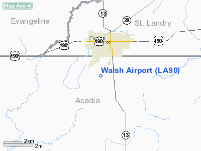
Location &
QuickFacts
|
FAA
Information Effective: |
2008-09-25 |
|
Airport
Identifier: |
LA90 |
|
Airport
Status: |
Operational |
|
Longitude/Latitude: |
092-25-34.4780W/30-27-39.7220N
-92.426244/30.461034 (Estimated) |
|
Elevation: |
26 ft / 7.92 m (Estimated) |
|
Land: |
10 acres |
|
From
nearest city: |
5 nautical miles SE of Crowley, LA |
|
Location: |
Acadia Parish, LA |
|
Magnetic Variation: |
03E (2000) |
Owner & Manager
|
Ownership: |
Privately owned |
|
Owner: |
Walsh Aviation Inc |
|
Address: |
Route 2 Box 373 Aa
Crowley, LA 70526 |
|
Phone number: |
318-783-7367 |
|
Manager: |
Phyllis Walsh |
|
Address: |
Route 2 Box 373
Crowley, LA 70526 |
|
Phone number: |
318-783-8011 |
Airport
Operations and Facilities
|
Airport
Use: |
Private |
|
Wind
indicator: |
Yes |
|
Segmented Circle: |
No |
|
Control
Tower: |
No |
|
Sectional chart: |
Houston |
|
Region: |
ASW - Southwest |
|
Boundary
ARTCC: |
ZHU - Houston |
|
Tie-in
FSS: |
DRI - De Ridder |
|
FSS on
Airport: |
No |
|
FSS Toll
Free: |
1-800-WX-BRIEF |
|
Runway Information
Runway 08/26
|
Dimension: |
2400 x 110 ft / 731.5 x 33.5 m |
|
Surface: |
TURF, |
|
|
Runway 08
|
Runway 26
|
|
Traffic
Pattern: |
Left |
Left |
|
Obstruction: |
45 ft plines, 200.0 ft from runway |
|
|
Radio Navigation Aids
|
ID |
Type |
Name |
Ch |
Freq |
Var |
Dist |
|
POE |
FAN MARKER |
South |
|
|
07E |
49.2 nm |
|
ECY |
NDB |
Eunice |
|
263.00 |
02E |
6.0 nm |
|
LRR |
NDB |
Allen Parish |
|
379.00 |
03E |
17.4 nm |
|
OPL |
NDB |
St Landry |
|
335.00 |
04E |
20.6 nm |
|
BWK |
NDB |
Bunkie |
|
397.00 |
03E |
26.3 nm |
|
AR |
NDB |
Acadi |
|
269.00 |
03E |
42.1 nm |
|
MKV |
NDB |
Marksville |
|
347.00 |
02E |
42.3 nm |
|
HZ |
NDB |
Hazer |
|
356.00 |
04E |
49.6 nm |
|
LLA |
VOR/DME |
White Lake |
041X |
110.40 |
04E |
48.0 nm |
|
LFT |
VORTAC |
Lafayette |
035X |
109.80 |
03E |
27.6 nm |
|
LCH |
VORTAC |
Lake Charles |
081X |
113.40 |
07E |
40.1 nm |
|
AEX |
VORTAC |
Alexandria |
108X |
116.10 |
03E |
48.0 nm |
Remarks
-
HVY AGRICULTURAL
FLYING OPNS DURING MAR THRU JUL.
-
BASED ON
PROXIMITY OF PROPOSAL TO LAWSON ARPT & THE INCOMPATIBLE TFC PATTERN AIRSPACE
AREAS THAT WOULD BE ASSOCIATED WITH THE TWO ARPTS.
Based Aircraft
|
Aircraft based
on field: |
2 |
|
Single Engine
Airplanes: |
2 |
Walsh Airport
Address:
Acadia Parish, LA
Tel:
318-783-7367, 318-783-8011
Images
and information placed above are from
http://www.airport-data.com/airport/LA90/
We
thank them for the data!
|
General Info |
| Country |
United
States |
| State |
LOUISIANA |
| FAA ID |
LA90
|
| Latitude |
30-27-39.722N |
|
Longitude |
092-25-34.478W |
|
Elevation |
26 feet
|
| Near
City |
CROWLEY
|
We don't guarantee the information is fresh and accurate. The data may
be wrong or outdated.
For more up-to-date information please refer to other sources.
|
|


