|
|
|
 |
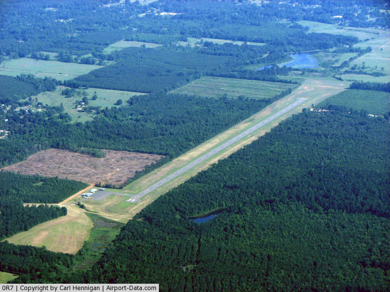
(Click on the photo to enlarge) |
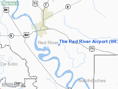
Location &
QuickFacts
|
FAA
Information Effective: |
2008-09-25 |
|
Airport
Identifier: |
0R7 |
|
Airport
Status: |
Operational |
|
Longitude/Latitude: |
093-18-28.2900W/31-59-25.0600N
-93.307858/31.990294 (Estimated) |
|
Elevation: |
177 ft / 53.95 m (Estimated) |
|
Land: |
63 acres |
|
From
nearest city: |
2 nautical miles SE of Coushatta, LA |
|
Location: |
Red River Parish, LA |
|
Magnetic Variation: |
05E (1985) |
Owner & Manager
|
Ownership: |
Publicly owned |
|
Owner: |
Red River Parish Police Jury |
|
Address: |
Po Drawer 709
Coushatta, LA 71019 |
|
Phone number: |
318-932-5719 |
|
Manager: |
Jessie Davis |
|
Address: |
Po Drawer 709
Coushatta, LA 71019 |
|
Phone number: |
318-932-5710 |
Airport
Operations and Facilities
|
Airport
Use: |
Open to public |
|
Wind
indicator: |
Yes |
|
Segmented Circle: |
No |
|
Control
Tower: |
No |
|
Lighting
Schedule: |
DUSK-DAWN
MIRL RY 17/35 PRESET LOW INTST; TO INCR INTST ACTVT - CTAF. |
|
Beacon
Color: |
Clear-Green (lighted land airport) |
|
Landing
fee charge: |
No |
|
Sectional chart: |
Houston |
|
Region: |
ASW - Southwest |
|
Boundary
ARTCC: |
ZFW - Fort Worth |
|
Tie-in
FSS: |
DRI - De Ridder |
|
FSS on
Airport: |
No |
|
FSS Toll
Free: |
1-800-WX-BRIEF |
|
NOTAMs
Facility: |
DRI (NOTAM-d service avaliable) |
|
Federal Agreements: |
NGY |
Airport Communications
Airport Services
|
Airframe
Repair: |
NONE |
|
Power
Plant Repair: |
NONE |
|
Bottled
Oxygen: |
NONE |
|
Bulk
Oxygen: |
NONE |
|
Runway Information
Runway 17/35
|
Dimension: |
5000 x 75 ft / 1524.0 x 22.9 m |
|
Surface: |
ASPH, Good Condition |
|
Weight Limit: |
Single wheel: 44000 lbs. |
|
Edge Lights: |
Medium |
|
|
Runway 17
|
Runway 35
|
|
Longitude: |
093-18-28.2900W |
093-18-28.2900W |
|
Latitude: |
31-59-49.8000N |
31-59-00.3100N |
|
Traffic
Pattern: |
Left |
Left |
|
Markings: |
Basic, Good Condition
CENTERLINE FADED. |
Basic, Good Condition
CENTERLINE FADED. |
|
Crossing
Height: |
50.00 ft |
50.00 ft |
|
VASI: |
2-light PAPI on left side |
2-light PAPI on left side |
|
Visual
Glide Angle: |
3.00° |
3.00° |
|
Runway End
Identifier: |
Yes |
Yes |
|
Obstruction: |
50 ft trees, 1445.0 ft from runway, 24:1 slope to clear |
50 ft trees, 1250.0 ft from runway, 250 ft left of
centerline, 21:1 slope to clear |
|
Radio Navigation Aids
|
ID |
Type |
Name |
Ch |
Freq |
Var |
Dist |
|
IE |
NDB |
Campi |
|
407.00 |
04E |
23.2 nm |
|
MSD |
NDB |
Mansfield |
|
414.00 |
04E |
23.7 nm |
|
MMY |
NDB |
Many |
|
272.00 |
04E |
27.9 nm |
|
JBL |
NDB |
Hodge |
|
256.00 |
04E |
32.2 nm |
|
IFJ |
NDB |
Winnfield |
|
402.00 |
04E |
33.2 nm |
|
MNE |
NDB |
Minden |
|
201.00 |
04E |
39.1 nm |
|
CZJ |
NDB |
Amason |
|
341.00 |
04E |
44.2 nm |
|
TUF |
NDB |
Stuckey |
|
350.00 |
03E |
44.4 nm |
|
BAD |
TACAN |
Barksdale |
105X |
|
05E |
35.9 nm |
|
DTN |
VOR |
Downtown |
|
108.60 |
07E |
39.7 nm |
|
SWB |
VOR/DME |
Sawmill |
84Y |
113.75 |
02E |
32.2 nm |
|
EMG |
VORTAC |
Elm Grove |
049X |
111.20 |
07E |
28.6 nm |
|
SHV |
VOT |
Shreveport Regional |
|
108.20 |
|
46.1 nm |
Based Aircraft
|
Aircraft based
on field: |
7 |
|
Single Engine
Airplanes: |
6 |
|
Multi Engine
Airplanes: |
1 |
Operational Statistics
Time Period: 2007-07-11 - 2008-07-09
|
Aircraft
Operations: |
77/Week |
|
General
Aviation Local: |
75.0% |
|
General
Aviation Itinerant: |
25.0% |
The Red River Airport
Address:
Red River Parish, LA
Tel:
318-932-5719, 318-932-5710
Images
and information placed above are from
http://www.airport-data.com/airport/0R7/
We
thank them for the data!
|
General Info |
| Country |
United
States |
| State |
LOUISIANA |
| FAA ID |
0R7
|
| Latitude |
31-59-26.581N |
|
Longitude |
093-18-26.615W |
|
Elevation |
177 feet
|
| Near
City |
COUSHATTA |
We don't guarantee the information is fresh and accurate. The data may
be wrong or outdated.
For more up-to-date information please refer to other sources.
|
|