 |
|
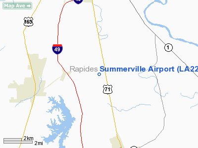
Location &
QuickFacts
|
FAA
Information Effective: |
2008-09-25 |
|
Airport
Identifier: |
LA22 |
|
Airport
Status: |
Operational |
|
Longitude/Latitude: |
092-25-19.4860W/31-09-43.6710N
-92.422079/31.162131 (Estimated) |
|
Elevation: |
77 ft / 23.47 m (Surveyed) |
|
Land: |
11 acres |
|
From
nearest city: |
4 nautical miles N of Lecompte, LA |
|
Location: |
Rapides Parish, LA |
|
Magnetic Variation: |
04E (1985) |
Owner & Manager
|
Ownership: |
Privately owned |
|
Owner: |
S. C. Summerville |
|
Address: |
|
|
Phone
number: |
318-442-7578 |
|
Manager: |
W. R. Mc Graw |
|
Address: |
P.o. Box 6067
Alexandria, LA 71301 |
|
Phone number: |
318-442-7578 |
Airport Operations and Facilities
|
Airport Use: |
Private |
|
Wind indicator: |
Yes |
|
Segmented Circle: |
No |
|
Control Tower: |
No |
|
Landing fee charge: |
No |
|
Sectional chart: |
Houston |
|
Region: |
ASW - Southwest |
|
Boundary ARTCC: |
ZHU - Houston |
|
Tie-in FSS: |
DRI - De Ridder |
|
FSS on Airport: |
No |
|
FSS Toll Free: |
1-800-WX-BRIEF |
Airport Services
|
Fuel
available: |
100LL |
|
Airframe
Repair: |
MAJOR |
|
Power
Plant Repair: |
MAJOR |
|
Runway Information
Runway 11/29
|
Dimension: |
3000 x 100 ft / 914.4 x 30.5 m |
|
Surface: |
TURF, Good Condition |
|
|
Runway 11
|
Runway 29
|
|
Traffic
Pattern: |
Left |
Left |
|
Obstruction: |
70 ft trees, 700.0 ft from runway, 10:1 slope to clear |
40 ft tree, 400.0 ft from runway, 50 ft right of
centerline, 8:1 slope to clear |
|
Radio Navigation Aids
|
ID |
Type |
Name |
Ch |
Freq |
Var |
Dist |
|
POE |
FAN MARKER |
South |
|
|
07E |
39.7 nm |
|
POE1 |
FAN MARKER |
North |
|
|
07E |
41.2 nm |
|
MKV |
NDB |
Marksville |
|
347.00 |
02E |
18.4 nm |
|
BWK |
NDB |
Bunkie |
|
397.00 |
03E |
20.3 nm |
|
LRR |
NDB |
Allen Parish |
|
379.00 |
03E |
34.2 nm |
|
OPL |
NDB |
St Landry |
|
335.00 |
04E |
34.7 nm |
|
ECY |
NDB |
Eunice |
|
263.00 |
02E |
36.2 nm |
|
GUV |
NDB |
Gator |
|
359.00 |
05E |
40.1 nm |
|
IE |
NDB |
Campi |
|
407.00 |
04E |
44.9 nm |
|
VED |
NDB |
Leesville |
|
247.00 |
04E |
47.5 nm |
|
IFJ |
NDB |
Winnfield |
|
402.00 |
04E |
49.6 nm |
|
AEX |
VORTAC |
Alexandria |
108X |
116.10 |
03E |
7.0 nm |
|
FXU |
VORTAC |
Polk |
021X |
108.40 |
05E |
41.1 nm |
Remarks
-
APCH: 10' BLDG AT
END OF PROPERTY LCTD OFF CNTR OF RWY.
-
APCH: HANGAR &
ACFT OFF CNTR OF RWY.
-
PRE DATES THE ACT
Based Aircraft
|
Aircraft based
on field: |
6 |
|
Single Engine
Airplanes: |
5 |
|
Ultralights: |
1 |
Operational Statistics
Time Period: 1986-02-06 - 1987-02-05
|
Aircraft
Operations: |
116/Week |
|
General
Aviation Local: |
60.0% |
|
General
Aviation Itinerant: |
40.0% |
Summerville Airport
Address:
Rapides Parish, LA
Tel:
318-442-7578
Images
and information placed above are from
http://www.airport-data.com/airport/LA22/
We
thank them for the data!
|
General Info |
| Country |
United
States |
| State |
LOUISIANA |
| FAA ID |
LA22
|
| Latitude |
31-09-43.671N |
|
Longitude |
092-25-19.486W |
|
Elevation |
77 feet
|
| Near
City |
LECOMPTE
|
We don't guarantee the information is fresh and accurate. The data may
be wrong or outdated.
For more up-to-date information please refer to other sources.
|
|


