 |
|
|
|
Location &
QuickFacts
|
FAA
Information Effective: |
2008-09-25 |
|
Airport
Identifier: |
LS80 |
|
Airport
Status: |
Operational |
|
Longitude/Latitude: |
092-52-31.5320W/30-26-02.7280N
-92.875426/30.434091 (Estimated) |
|
Elevation: |
35 ft / 10.67 m (Estimated) |
|
Land: |
0 acres |
|
From
nearest city: |
3 nautical miles SW of Kinder, LA |
|
Location: |
Jefferson Davis Parish, LA |
|
Magnetic Variation: |
05E (1985) |
Owner & Manager
|
Ownership: |
Privately owned |
|
Owner: |
Tennessee Gas Pipeline Co. |
|
Address: |
158 Regal Row
Houma, LA 70360
SUGAR MILL POINT. |
|
Phone
number: |
985-868-6785 |
|
Manager: |
K. J. Cheramie
RIGHT OF WAY AGENT. |
|
Address: |
158 Regal Row
Houma, LA 70360
SUGAR MILL POINT. |
|
Phone number: |
985-223-6417 |
Airport Operations and Facilities
|
Airport
Use: |
Private |
|
Wind
indicator: |
Yes |
|
Segmented Circle: |
No |
|
Control
Tower: |
No |
|
Lighting
Schedule: |
PHONE REQ
FOR PERIMETER LGTS CALL 504-868-6785. |
|
Sectional chart: |
Houston |
|
Region: |
ASW - Southwest |
|
Boundary
ARTCC: |
ZHU - Houston |
|
Tie-in
FSS: |
DRI - De Ridder |
|
FSS on
Airport: |
No |
|
FSS Toll
Free: |
1-800-WX-BRIEF |
|
Runway Information
Helipad H1
|
Dimension: |
50 x 50 ft / 15.2 x 15.2 m |
|
Surface: |
CONC, |
|
|
Runway H1
|
Runway
|
|
Traffic
Pattern: |
Left |
Left |
|
Radio Navigation Aids
|
ID |
Type |
Name |
Ch |
Freq |
Var |
Dist |
|
POE |
FAN MARKER |
South |
|
|
07E |
36.0 nm |
|
POE1 |
FAN MARKER |
North |
|
|
07E |
44.4 nm |
|
LRR |
NDB |
Allen Parish |
|
379.00 |
03E |
15.7 nm |
|
ECY |
NDB |
Eunice |
|
263.00 |
02E |
23.4 nm |
|
DR |
NDB |
Idder |
|
385.00 |
04E |
30.5 nm |
|
DQU |
NDB |
De Quincy |
|
410.00 |
05E |
30.6 nm |
|
UX |
NDB |
Sulfy |
|
278.00 |
04E |
31.6 nm |
|
GUV |
NDB |
Gator |
|
359.00 |
05E |
39.1 nm |
|
BWK |
NDB |
Bunkie |
|
397.00 |
03E |
42.1 nm |
|
OPL |
NDB |
St Landry |
|
335.00 |
04E |
42.4 nm |
|
VED |
NDB |
Leesville |
|
247.00 |
04E |
46.8 nm |
|
LCH |
VORTAC |
Lake Charles |
081X |
113.40 |
07E |
21.3 nm |
|
FXU |
VORTAC |
Polk |
021X |
108.40 |
05E |
44.4 nm |
|
LFT |
VORTAC |
Lafayette |
035X |
109.80 |
03E |
48.0 nm |
Remarks
-
PRVDD VFR; A LGTD
WIND CONE OR SIMILAR DEVICE MAINTAINED; A SAFETY BARRIER IS INSTALLED; A SIGN
IS PLACED WARNING OF HELICOPTER OPNS AREA; AND INGRESS/EGRESS ROUTES ARE FROM
N THRU W (360 DEG COUNTER CLOCKWISE TO 270 DEG).
Based Aircraft
|
Aircraft based
on field: |
4 |
|
Helicopters: |
4 |
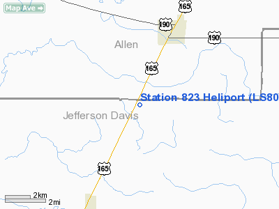
Station 823 Heliport
Address:
Jefferson Davis Parish, LA
Tel:
985-868-6785,
985-223-6417
Images
and information placed above are from
http://www.airport-data.com/airport/LS80/
We
thank them for the data!
|
General Info |
| Country |
United
States |
| State |
LOUISIANA |
| FAA ID |
LS80
|
| Latitude |
30-26-02.728N |
|
Longitude |
092-52-31.532W |
|
Elevation |
35 feet
|
| Near
City |
KINDER
|
We don't guarantee the information is fresh and accurate. The data may
be wrong or outdated.
For more up-to-date information please refer to other sources.
|
|


