 |
|
St. Tammany Regional Airport |
| St. Tammany Regional Airport |
| IATA: none â ICAO: none â FAA LID: L31 |
| Summary |
| Airport type |
Public |
| Owner |
St. Tammany Parish |
| Location |
Covington, Louisiana |
| Elevation AMSL |
39 ft / 12 m |
| Coordinates |
30°26â²42â³N 089°59â²20â³W / 30.445°N 89.98889°W / 30.445; -89.98889 (St. Tammany Regional Airport (L31)) |
| Runways |
| Direction |
Length |
Surface |
| ft |
m |
| 18/36 |
2,999 |
914 |
Asphalt |
| Statistics (2009) |
| Aircraft operations |
25,600 |
| Based aircraft |
18 |
| Source: Federal Aviation Administration |
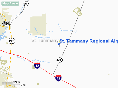
St. Tammany Regional Airport (FAA LID: L31) is a public use airport in St. Tammany Parish, Louisiana, United States. It is owned by St. Tammany Parish and located six nautical miles (11 km) southeast of the central business district of Covington, Louisiana. Facilities and aircraft
St. Tammany Regional Airport covers an area of 42 acres (17 ha) at an elevation of 39 feet (12 m) above mean sea level. It has one runway designated 18/36 with an asphalt surface measuring 2,999 by 75 feet (914 x 23 m).
For the 12-month period ending April 15, 2009, the airport had 25,600 aircraft operations, an average of 70 per day: 98% general aviation and 2% air taxi and <1% military. At that time there were 18 aircraft based at this airport: 13 single-engine, 3 multi-engine, 1 helicopter and 1 ultralight.
The above content comes from Wikipedia and is published under free licenses – click here to read more.
Location &
QuickFacts
|
FAA
Information Effective: |
2008-09-25 |
|
Airport
Identifier: |
L31 |
|
Airport
Status: |
Operational |
|
Longitude/Latitude: |
089-59-19.9640W/30-26-42.1950N
-89.988879/30.445054 (Estimated) |
|
Elevation: |
39 ft / 11.89 m (Surveyed) |
|
Land: |
42 acres |
|
From
nearest city: |
6 nautical miles SE of Covington, LA |
|
Location: |
St Tammany Parish, LA |
|
Magnetic Variation: |
02E (1995) |
Owner & Manager
|
Ownership: |
Publicly owned |
|
Owner: |
St Tammany Parish |
|
Address: |
Po Box 628
Covington, LA 70434 |
|
Phone number: |
985-898-2362 |
|
Manager: |
James Smith |
|
Address: |
Po Box 628
Covington, LA 70434 |
|
Phone number: |
985-875-2601 |
Airport
Operations and Facilities
|
Airport
Use: |
Open to public |
|
Wind
indicator: |
Yes |
|
Segmented Circle: |
No |
|
Control
Tower: |
No |
|
Lighting
Schedule: |
DUSK-DAWN
MIRL RY 18/36 PRESET MED INTST. |
|
Beacon
Color: |
Clear-Green (lighted land airport) |
|
Landing
fee charge: |
No |
|
Sectional chart: |
New Orleans |
|
Region: |
ASW - Southwest |
|
Boundary
ARTCC: |
ZHU - Houston |
|
Tie-in
FSS: |
DRI - De Ridder |
|
FSS on
Airport: |
No |
|
FSS Toll
Free: |
1-800-WX-BRIEF |
|
NOTAMs
Facility: |
DRI (NOTAM-d service avaliable) |
|
Federal Agreements: |
N |
Airport Communications
|
CTAF: |
122.800 |
|
Unicom: |
122.800 |
Airport Services
|
Fuel
available: |
100LL
SELF SERVICE FUEL AVBL 24 HRS WITH CREDIT CARD. |
|
Runway Information
Runway 18/36
|
Dimension: |
2999 x 75 ft / 914.1 x 22.9 m |
|
Surface: |
ASPH, Good Condition |
|
Weight Limit: |
Single wheel: 17500 lbs. |
|
Edge Lights: |
Medium |
|
|
Runway 18
|
Runway 36
|
|
Longitude: |
089-59-20.0480W |
089-59-19.9820W |
|
Latitude: |
30-26-57.0430N |
30-26-27.3570N |
|
Elevation: |
39.00 ft |
38.00 ft |
|
Alignment: |
127 |
127 |
|
Traffic
Pattern: |
Left |
Left |
|
Markings: |
Non-precision instrument, Good Condition |
Non-precision instrument, Good Condition |
|
Crossing
Height: |
19.00 ft |
21.00 ft |
|
VASI: |
2-box SAVASI on left side
RYS 18 & 36 SAVASI OTS INDEFLY. |
2-box SAVASI on left side |
|
Visual
Glide Angle: |
4.00° |
4.00° |
|
Obstruction: |
60 ft trees, 1220.0 ft from runway, 200 ft right of
centerline, 17:1 slope to clear |
60 ft trees, 995.0 ft from runway, 180 ft right of
centerline, 13:1 slope to clear |
|
Radio Navigation Aids
|
ID |
Type |
Name |
Ch |
Freq |
Var |
Dist |
|
FNA |
NDB |
Florenville |
|
371.00 |
03E |
8.9 nm |
|
DEF |
NDB |
Slidell |
|
256.00 |
03E |
12.0 nm |
|
MJD |
NDB |
Picayune |
|
276.00 |
01E |
17.6 nm |
|
BX |
NDB |
Carma |
|
353.00 |
02E |
27.0 nm |
|
AYI |
NDB |
Hanco |
|
221.00 |
03E |
27.6 nm |
|
HS |
NDB |
Hanco |
|
221.00 |
01E |
27.6 nm |
|
MS |
NDB |
Kinte |
|
338.00 |
03E |
33.1 nm |
|
HMU |
VOR |
Hammond |
|
109.60 |
03E |
22.6 nm |
|
PCU |
VOR/DME |
Picayune |
059X |
112.20 |
05E |
15.1 nm |
|
RQR |
VOR/DME |
Reserve |
045X |
110.80 |
02E |
37.8 nm |
|
GPT |
VOR/DME |
Gulfport |
27X |
109.00 |
02E |
47.4 nm |
|
HRV |
VORTAC |
Harvey |
088X |
114.10 |
02E |
35.8 nm |
|
NEW |
VOT |
New Orleans Lakefront |
|
111.00 |
|
24.4 nm |
Based Aircraft
|
Aircraft based
on field: |
18 |
|
Single Engine
Airplanes: |
13 |
|
Multi Engine
Airplanes: |
3 |
|
Helicopters: |
1 |
|
Ultralights: |
1 |
Operational Statistics
Time Period: 2007-04-17 - 2008-04-15
|
Aircraft
Operations: |
71/Day |
|
Air Taxi: |
2.0% |
|
General
Aviation Local: |
58.6% |
|
General
Aviation Itinerant: |
39.1% |
|
Military: |
0.4% |
St. Tammany Regional Airport
Address:
St Tammany Parish, LA
Tel:
985-898-2362, 985-875-2601
Images
and information placed above are from
http://www.airport-data.com/airport/L31/
We
thank them for the data!
|
General Info |
| Country |
United
States |
| State |
LOUISIANA |
| FAA ID |
L31
|
| Latitude |
30.445055
30° 26' 42.20" N |
|
Longitude |
-89.988876
089° 59' 19.95" W |
|
Elevation |
39 feet
12 meters |
| Magnetic
Variation |
000° E
(01/06) |
| Beacon |
Yes
|
|
Operating Agency |
MUNICIPAL |
We don't guarantee the information is fresh and accurate. The data may
be wrong or outdated.
For more up-to-date information please refer to other sources.
|
|


