 |
|
| Ruston Regional Airport |
| IATA: RSN â ICAO: KRSN â FAA LID: RSN |
| Summary |
| Airport type |
Public |
| Owner |
City of Ruston |
| Serves |
Ruston, Louisiana |
| Elevation AMSL |
311 ft / 95 m |
| Coordinates |
32°30â²53â³N 092°35â²18â³W / 32.51472°N 92.58833°W / 32.51472; -92.58833 |
| Runways |
| Direction |
Length |
Surface |
| ft |
m |
| 18/36 |
5,000 |
1,524 |
Asphalt |
| Statistics (2009) |
| Aircraft operations |
86,000 |
| Based aircraft |
32 |
| Source: Federal Aviation Administration |
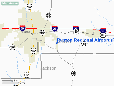
Ruston Regional Airport (IATA: RSN, ICAO: KRSN, FAA LID: RSN) is a public use airport in Lincoln Parish, Louisiana, United States. It is owned by the City of Ruston and is located three nautical miles (6 km) east of its central business district.
Opening in 1995, the facility also serves the Louisiana Tech University's Department of Professional Aviation.
Facilities and aircraft
Ruston Regional Airport covers an area of 238 acres (96 ha) at an elevation of 311 feet (95 m) above mean sea level. It has one runway designated 18/36 with an asphalt surface measuring 5,000 by 100 feet (1,524 x 30 m).
For the 12-month period ending April 17, 2009, the airport had 86,000 general aviation aircraft operations, an average of 235 per day. At that time there were 32 aircraft based at this airport: 81% single-engine, 6% multi-engine, 9% jet and 3% helicopter.
The above content comes from Wikipedia and is published under free licenses – click here to read more.
Location &
QuickFacts
|
FAA
Information Effective: |
2008-09-25 |
|
Airport
Identifier: |
RSN |
|
Airport
Status: |
Operational |
|
Longitude/Latitude: |
092-35-18.3962W/32-30-52.5663N
-92.588443/32.514602 (Estimated) |
|
Elevation: |
311 ft / 94.79 m (Estimated) |
|
Land: |
238 acres |
|
From
nearest city: |
3 nautical miles E of Ruston, LA |
|
Location: |
Lincoln Parish, LA |
|
Magnetic Variation: |
03E (1995) |
Owner & Manager
|
Ownership: |
Publicly owned |
|
Owner: |
City Of Ruston |
|
Address: |
401 N. Trenton
Ruston, LA 71270 |
|
Phone
number: |
318-251-8620 |
|
Manager: |
James E Davison Jr |
|
Address: |
Ruston Aviation, 125 Flightline Dr
Ruston, LA 71270 |
|
Phone number: |
318-251-9098 |
Airport Operations and Facilities
|
Airport
Use: |
Open to public |
|
Wind
indicator: |
Yes |
|
Segmented Circle: |
Yes |
|
Control
Tower: |
No |
|
Lighting
Schedule: |
DUSK-DAWN
MIRL RY 18/36 PRESET LOW INTST; TO INCR INTST ACTVT - CTAF. |
|
Beacon
Color: |
Clear-Green (lighted land airport) |
|
Sectional chart: |
Memphis |
|
Region: |
ASW - Southwest |
|
Traffic
Pattern Alt: |
1000 ft |
|
Boundary
ARTCC: |
ZFW - Fort Worth |
|
Tie-in
FSS: |
DRI - De Ridder |
|
FSS on
Airport: |
No |
|
FSS Toll
Free: |
1-800-WX-BRIEF |
|
NOTAMs
Facility: |
RSN (NOTAM-d service avaliable) |
|
Federal Agreements: |
NGY |
Airport Communications
|
CTAF: |
122.700 |
|
Unicom: |
122.700 |
Airport Services
|
Fuel
available: |
100LLA |
|
Airframe
Repair: |
MINOR |
|
Power
Plant Repair: |
MINOR |
|
Runway Information
Runway 18/36
|
Dimension: |
5000 x 100 ft / 1524.0 x 30.5 m |
|
Surface: |
ASPH, Good Condition |
|
Edge Lights: |
Medium |
|
|
Runway 18
|
Runway 36
|
|
Longitude: |
092-35-18.3644W |
092-35-18.4279W |
|
Latitude: |
32-31-17.3051N |
32-30-27.8274N |
|
Elevation: |
276.00 ft |
310.00 ft |
|
Alignment: |
127 |
0 |
|
Traffic
Pattern: |
Left |
Left |
|
Markings: |
Non-precision instrument, Fair Condition
RY 18/36 MARKINGS FADED. |
Non-precision instrument, Fair Condition |
|
Crossing
Height: |
40.00 ft |
35.00 ft |
|
Displaced
threshold: |
0.00 ft |
199.00 ft |
|
VASI: |
4-light PAPI on left side |
4-light PAPI on left side |
|
Visual
Glide Angle: |
3.00° |
3.50° |
|
Obstruction: |
, 50:1 slope to clear |
50 ft trees, 900.0 ft from runway, 250 ft right of
centerline, 14:1 slope to clear
APCH SLOPE 20:1 TO DSPLCD THLD. |
|
Radio Navigation Aids
|
ID |
Type |
Name |
Ch |
Freq |
Var |
Dist |
|
ROQ |
NDB |
Ruston |
|
368.00 |
03E |
5.6 nm |
|
TUF |
NDB |
Stuckey |
|
350.00 |
03E |
6.4 nm |
|
JBL |
NDB |
Hodge |
|
256.00 |
04E |
20.1 nm |
|
HMQ |
NDB |
Homer |
|
212.00 |
02E |
26.6 nm |
|
IFJ |
NDB |
Winnfield |
|
402.00 |
04E |
33.3 nm |
|
MNE |
NDB |
Minden |
|
201.00 |
04E |
36.9 nm |
|
BQP |
NDB |
Bastrop |
|
329.00 |
03E |
38.5 nm |
|
MRK |
NDB |
Molly Ridge |
|
338.00 |
02E |
41.9 nm |
|
SPH |
NDB |
Springhill |
|
375.00 |
05E |
48.1 nm |
|
SWB |
VOR/DME |
Sawmill |
84Y |
113.75 |
02E |
32.9 nm |
|
MLU |
VORTAC |
Monroe |
119X |
117.20 |
03E |
28.0 nm |
|
ELD |
VORTAC |
El Dorado |
102X |
115.50 |
07E |
45.3 nm |
Remarks
-
NUMEROUS TRNG
ACFT IN VICINITY.
-
PRVDD ALL
CONDITIONS LISTED IN THE 2/10/94 LTR ARE ADHERED TO.
Based Aircraft
|
Aircraft based
on field: |
39 |
|
Single Engine
Airplanes: |
30 |
|
Multi Engine
Airplanes: |
6 |
|
Jet Engine
Airplanes: |
2 |
|
Helicopters: |
1 |
Operational Statistics
Time Period: 2007-05-02 - 2008-04-30
|
Aircraft
Operations: |
236/Day |
|
General
Aviation Local: |
93.0% |
|
General
Aviation Itinerant: |
7.0% |
Ruston Regional Airport
Address:
Lincoln Parish, LA
Tel:
318-251-8620,
318-251-9098
Images
and information placed above are from
http://www.airport-data.com/airport/RSN/
We
thank them for the data!
|
General Info |
| Country |
United
States |
| State |
LOUISIANA |
| FAA ID |
RSN
|
| Latitude |
32-30-52.000N |
|
Longitude |
092-35-18.000W |
|
Elevation |
311 feet
|
| Near
City |
RUSTON
|
We don't guarantee the information is fresh and accurate. The data may
be wrong or outdated.
For more up-to-date information please refer to other sources.
|
|


