 |
|
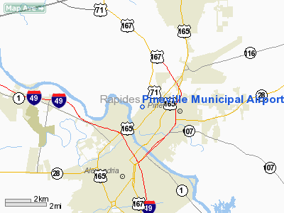
Pineville Municipal Airport |
|
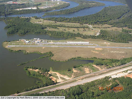 |
(Click on the photo to enlarge) |
Location &
QuickFacts
|
FAA
Information Effective: |
2008-09-25 |
|
Airport
Identifier: |
2L0 |
|
Airport
Status: |
Operational |
|
Longitude/Latitude: |
092-26-36.8800W/31-20-31.8900N
-92.443578/31.342192 (Estimated) |
|
Elevation: |
100 ft / 30.48 m (Estimated) |
|
Land: |
103 acres |
|
From
nearest city: |
2 nautical miles N of Pineville, LA |
|
Location: |
Rapides Parish, LA |
|
Magnetic Variation: |
04E (1985) |
Owner & Manager
|
Ownership: |
Publicly owned |
|
Owner: |
City Of Pineville |
|
Address: |
P. O. Box 3820
Pineville, LA 71361-3820 |
|
Phone
number: |
318-445-7163 |
|
Manager: |
Lonnie Lucius |
|
Address: |
200 Lake Buhlow Rd
Pineville, LA 71360 |
|
Phone number: |
318-445-7163 |
Airport Operations and Facilities
|
Airport
Use: |
Open to public |
|
Wind
indicator: |
Yes |
|
Segmented Circle: |
No |
|
Control
Tower: |
No |
|
Lighting
Schedule: |
DUSK-DAWN
MIRL RY 18/36 PRESET ON LOW INTST; TO INCR INTST & ACTVT REIL RYS 18 &
36 - CTAF. |
|
Beacon
Color: |
Clear-Green (lighted land airport) |
|
Landing
fee charge: |
No |
|
Sectional chart: |
Houston |
|
Region: |
ASW - Southwest |
|
Boundary
ARTCC: |
ZHU - Houston |
|
Tie-in
FSS: |
DRI - De Ridder |
|
FSS on
Airport: |
No |
|
FSS Toll
Free: |
1-800-WX-BRIEF |
|
NOTAMs
Facility: |
DRI (NOTAM-d service avaliable) |
Airport Communications
|
CTAF: |
122.800 |
|
Unicom: |
122.800 |
Airport Services
|
Fuel
available: |
100LL
FOR FUEL AFT HRS CALL 318-449-5679. |
|
Airframe
Repair: |
MAJOR |
|
Power
Plant Repair: |
MAJOR |
|
Bottled
Oxygen: |
NONE |
|
Bulk
Oxygen: |
NONE |
|
Runway Information
Runway 05W/23W
|
Dimension: |
3000 x 100 ft / 914.4 x 30.5 m |
|
Surface: |
WATER, |
|
|
Runway 05W
|
Runway 23W
|
|
Traffic
Pattern: |
Right |
Left |
|
Runway 18/36
|
Dimension: |
3000 x 75 ft / 914.4 x 22.9 m |
|
Surface: |
ASPH, Good Condition |
|
Weight Limit: |
Single wheel: 15500 lbs. |
|
Edge Lights: |
Medium |
|
|
Runway 18
|
Runway 36
|
|
Longitude: |
092-26-36.7100W |
092-26-37.0400W |
|
Latitude: |
31-20-46.7400N |
31-20-17.0400N |
|
Traffic
Pattern: |
Left |
Left |
|
Markings: |
Non-precision instrument, Fair Condition
MARKINGS SLIGHTLY FADED. |
Non-precision instrument, Fair Condition
MARKINGS SLIGHTLY FADED. |
|
Crossing
Height: |
68.00 ft |
49.00 ft |
|
VASI: |
2-light PAPI on left side |
2-light PAPI on right side |
|
Visual
Glide Angle: |
4.00° |
3.00° |
|
Runway End
Identifier: |
Yes |
Yes |
|
Obstruction: |
50 ft trees, 500.0 ft from runway, 200 ft right of
centerline, 6:1 slope to clear |
60 ft trees, 1700.0 ft from runway, 25:1 slope to clear |
|
Radio Navigation Aids
|
ID |
Type |
Name |
Ch |
Freq |
Var |
Dist |
|
POE1 |
FAN MARKER |
North |
|
|
07E |
42.3 nm |
|
POE |
FAN MARKER |
South |
|
|
07E |
43.0 nm |
|
MKV |
NDB |
Marksville |
|
347.00 |
02E |
24.2 nm |
|
BWK |
NDB |
Bunkie |
|
397.00 |
03E |
30.6 nm |
|
IE |
NDB |
Campi |
|
407.00 |
04E |
37.6 nm |
|
IFJ |
NDB |
Winnfield |
|
402.00 |
04E |
38.9 nm |
|
GUV |
NDB |
Gator |
|
359.00 |
05E |
42.5 nm |
|
LRR |
NDB |
Allen Parish |
|
379.00 |
03E |
44.0 nm |
|
OPL |
NDB |
St Landry |
|
335.00 |
04E |
44.9 nm |
|
ECY |
NDB |
Eunice |
|
263.00 |
02E |
47.0 nm |
|
VED |
NDB |
Leesville |
|
247.00 |
04E |
48.4 nm |
|
SWB |
VOR/DME |
Sawmill |
84Y |
113.75 |
02E |
39.8 nm |
|
AEX |
VORTAC |
Alexandria |
108X |
116.10 |
03E |
5.9 nm |
|
FXU |
VORTAC |
Polk |
021X |
108.40 |
05E |
42.1 nm |
Remarks
-
RY 36 LAKE 96 FT
FM END OF RY.
-
RY 18 DROP OFF 95
FT FM END OF RY.
Based Aircraft
|
Aircraft based
on field: |
30 |
|
Single Engine
Airplanes: |
29 |
|
Multi Engine
Airplanes: |
1 |
Operational Statistics
Time Period: 2007-03-22 - 2008-03-20
|
Aircraft
Operations: |
70/Day |
|
General
Aviation Local: |
58.8% |
|
General
Aviation Itinerant: |
39.2% |
|
Military: |
2.0% |
Pineville Municipal Airport
Address:
Rapides Parish, LA
Tel:
318-445-7163
Images
and information placed above are from
http://www.airport-data.com/airport/2L0/
We
thank them for the data!
|
General Info |
| Country |
United
States |
| State |
LOUISIANA |
| FAA ID |
2L0
|
| Latitude |
31-20-46.000N |
|
Longitude |
092-26-37.000W |
|
Elevation |
100 feet
|
| Near
City |
PINEVILLE |
We don't guarantee the information is fresh and accurate. The data may
be wrong or outdated.
For more up-to-date information please refer to other sources.
|
|


