|
|
New Orleans Nas Jrb /alvin Callender Field/ Airport |
Naval Air Station
Joint Reserve Base New Orleans
Alvin Callender Field |
 |
| Insignia for NAS/JRB New Orleans |
| IATA: NBG â ICAO: KNBG â FAA LID: NBG |
| Summary |
| Airport type |
Military: Naval Air Station |
| Operator |
United States Navy |
| Location |
Belle Chasse, Louisiana (current location) |
| Built |
Aug 1954 - Dec 13, 1957 (current facility) |
| In use |
Apr 26, 1958 - Present |
| Commander |
Captain William J. Snyder |
| Occupants |
United States Navy |
| Elevation AMSL |
3 ft / 1 m |
| Coordinates |
29°49â²31â³N 090°02â²06â³W / 29.82528°N 90.035°W / 29.82528; -90.035 |
| Website |
www.nasjrbnola.navy.mil |
| Runways |
| Direction |
Length |
Surface |
| ft |
m |
| 4/22 |
9,999 |
3,048 |
PEM |
| 14/32 |
6,000 |
1,829 |
PEM |
| Source: Federal Aviation Administration |
Naval Air Station Joint Reserve Base New Orleans is a base of the United States military located in Belle Chasse, unincorporated Plaquemines Parish, Louisiana, United States. NAS JRB New Orleans is home to the 159th Fighter Wing as well as other naval activities. It contains a military airport known as Alvin Callender Field (IATA: NBG, ICAO: KNBG, FAA LID: NBG) which is located three nautical miles (6 km) south of the central business district of New Orleans. The base's predecessor, NAS New Orleans, occupied the current location of the University of New Orleans' principal campus until 1957. Occupants
Current occupants
- Fourth Marine Aircraft Wing
- Marine Air Group 42
- Strike Fighter Squadron 204 (VFA-204)
- 159th Fighter Wing (159 FW), Louisiana Air National Guard
- Fleet Logistics Support Squadron 54 (VR-54)
- Coast Guard Air Station New Orleans
- NCTAMS LANT Det New Orleans
- 3rd Battalion, 23rd Marines
- Navy Operational Support Center New Orleans
- 377th Theater Support Command
- FRC Mid-Atlantic Site New Orleans
- Region Legal Service Office Southeast Det New Orleans
- Civil Air Patrol, SWR-LA-086
Previous occupants
- VP-94
- VC-13 (redesignated VFC-13)
- Marine Aircraft Group 46 Detachment B
- 926th Fighter Wing (Air Force Reserve Command)
- U.S. Customs Service air operations
 | |
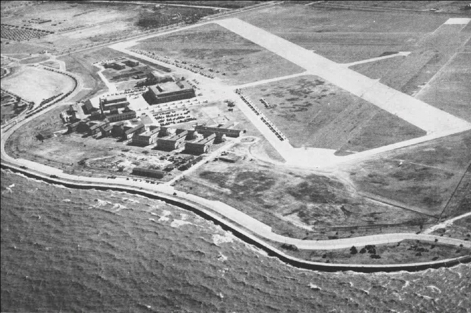
NAS New Orleans in the 1940s, located on the present-day main campus of the University of New Orleans |
Facilities
New Orleans NAS JRB (Alvin Callender Field) has two runways with PEM surfaces: 4/22 is 9,999 by 200 feet (3,048 x 61 m) and 14/32 is 6,000 by 200 feet (1,829 x 61 m).
The above content comes from Wikipedia and is published under free licenses – click here to read more.
_louisiana_usa_01.png)
Location &
QuickFacts
|
FAA
Information Effective: |
2008-09-25 |
|
Airport
Identifier: |
NBG |
|
Airport
Status: |
Operational |
|
Longitude/Latitude: |
090-02-06.0000W/29-49-31.2000N
-90.035000/29.825333 (Estimated) |
|
Elevation: |
3 ft / 0.91 m (Estimated) |
|
Land: |
0 acres |
|
From
nearest city: |
3 nautical miles S of New Orleans, LA |
|
Location: |
Jefferson Parish, LA |
|
Magnetic Variation: |
01E (2000) |
Owner & Manager
|
Ownership: |
Navy owned |
|
Owner: |
U S Navy |
|
Address: |
Oceanogrpahic Ofc-code 3142
Washington, D C 20373 |
|
Manager: |
Commanding Officer |
|
Address: |
Nas New Orleans
New Orleans, LA 70146 |
Airport
Operations and Facilities
|
Airport
Use: |
Private |
|
Segmented Circle: |
No |
|
Control
Tower: |
Yes |
|
Lighting
Schedule: |
DUSK-DAWN |
|
Beacon
Color: |
Split-Clear-Green (lighted military airport) |
|
Sectional chart: |
New Orleans |
|
Region: |
ASW - Southwest |
|
Boundary
ARTCC: |
ZHU - Houston |
|
Tie-in
FSS: |
DRI - De Ridder |
|
FSS on
Airport: |
No |
|
FSS Toll
Free: |
1-800-WX-BRIEF |
|
NOTAMs
Facility: |
MSY (NOTAM-d service avaliable) |
Airport Services
|
Airframe
Repair: |
NONE |
|
Power
Plant Repair: |
NONE |
|
Bottled
Oxygen: |
NONE |
|
Bulk
Oxygen: |
NONE |
|
Runway Information
Runway 04/22
|
Dimension: |
9999 x 200 ft / 3047.7 x 61.0 m |
|
Surface: |
PEM, |
|
Pavement
Class: |
59 /R/C/W/T |
|
Edge Lights: |
High |
|
|
Runway 04
|
Runway 22
|
|
ILS Type: |
LOC/GS |
|
|
Traffic
Pattern: |
Left |
Right |
|
Arresting: |
E28B |
E28B |
|
VASI: |
4-light PAPI on left side |
4-light PAPI on left side |
|
Approach
lights: |
ALSF1 |
SALS |
|
Runway 14/32
|
Dimension: |
6000 x 200 ft / 1828.8 x 61.0 m |
|
Surface: |
PEM, |
|
Pavement
Class: |
71 /R/C/W/T |
|
Edge Lights: |
Medium |
|
|
Runway 14
|
Runway 32
|
|
Traffic
Pattern: |
Left |
Left |
|
Arresting: |
E28B |
E28B |
|
Radio Navigation Aids
|
ID |
Type |
Name |
Ch |
Freq |
Var |
Dist |
|
MS |
NDB |
Kinte |
|
338.00 |
03E |
22.5 nm |
|
DEF |
NDB |
Slidell |
|
256.00 |
03E |
30.2 nm |
|
FNA |
NDB |
Florenville |
|
371.00 |
03E |
37.2 nm |
|
MJD |
NDB |
Picayune |
|
276.00 |
01E |
44.9 nm |
|
AYI |
NDB |
Hanco |
|
221.00 |
03E |
48.2 nm |
|
HS |
NDB |
Hanco |
|
221.00 |
01E |
48.2 nm |
|
HMU |
VOR |
Hammond |
|
109.60 |
03E |
46.2 nm |
|
RQR |
VOR/DME |
Reserve |
045X |
110.80 |
02E |
32.9 nm |
|
PCU |
VOR/DME |
Picayune |
059X |
112.20 |
05E |
47.0 nm |
|
HRV |
VORTAC |
Harvey |
088X |
114.10 |
02E |
2.2 nm |
|
LEV |
VORTAC |
Leeville |
082X |
113.50 |
02E |
39.2 nm |
|
TBD |
VORTAC |
Tibby |
057X |
112.00 |
02E |
42.6 nm |
|
NEW |
VOT |
New Orleans Lakefront |
|
111.00 |
|
12.9 nm |
Remarks
-
RSTD: PPR ALL
ACFT DSN 678-3602/3, C504-678-3602/3.
-
CSTMS/AG/IMG:
CSTMS AVBL 2 HR PN. CTC CSTMS C504-269-6149, FTS 269-6149FOR APPOINTMENT.
AG INSPECTION
UNAVBL.
-
TRAN ALERT: OPR 1300-0500Z++.
-
CAUTION: NUMEROUS
CIV ACFT OPR TO/FR CANALS VCNTY AFLD.
-
A-GEAR: DO NOT
LAND DRCT ON A-GEAR CABLE.
-
CG - OPR RSTD
0500-1300Z++ TO CG.
DSN 678-3515, C504-678-6032.
-
TFC PAT: REDUCED
RWY SEPARATION IN EFF FOR ALL LCL BASED TACTICAL ACFT; 3000' BTN SIMILAR ACFT;
6000' BTN DISSIMILAR ACFT. TRANSIENT ACFT MAY UTILIZE REDUCED RWY SEPARATION
ONLY AFTER BEING BRIEFED.
-
RWY-LGTS: RWY 04
- OLS & WAVE-OFF.
RWY 22 - OLS & WAVE-OFF.
-
RWY-LGTS: RWY 14
- LIGHTS. RWY 32 - OLS & LIGHTS.
-
SERVICE-LGT: OLS
RWY 04-22, 14-32 OUT OF SVC INDEF. NO DISTANCE REMAINING MARKERS AVBL FOR RWY
14-32.
-
JASU:
4(A/M-47A-4) 4(NC-10) LTD DC PWR.
-
FUEL: OPR
1330-0430Z++. FUEL DELAYS FRI-SUN. TRAN ACFT EXP SOME DELAY FOR SVC OUTSIDE
NML WORKING HR.
J8
-
OIL: O-128-156.
-
FLUID: PRESAIR LHOX LOX.
-
CAUTION: BIRD HAZ.
-
MISC: LTD
CLASSIFIED MATERIAL STOR. CTC BASE OPS DSN 678-3100, C504-678-3100 OR FAX DSN
678-9575, C504-678-9575.
-
MISC: CLASS D
AIRSPACE EFF 1300-0500Z++, OT CIV ACFT TRNS CLASS D, CTC ATC ON 123.8 FOR CLNC.
-
CAT B AFLD.
-
NUMEROUS BIRDS ON
& INVOF ARPT.
New Orleans Nas Jrb /alvin Callender
Field/ Airport
Address:
Jefferson Parish, LA
Tel:
Images
and information placed above are from
http://www.airport-data.com/airport/NBG/
We
thank them for the data!
|
General Info |
| Country |
United
States |
| State |
LOUISIANA |
| FAA ID |
NBG
|
| Latitude |
29-49-30.747N |
|
Longitude |
090-02-06.256W |
|
Elevation |
3 feet
|
| Near
City |
NEW
ORLEANS |
We don't guarantee the information is fresh and accurate. The data may
be wrong or outdated.
For more up-to-date information please refer to other sources.
|
|