 |
|
Natchitoches Regional Airport |
| Natchitoches Regional Airport |
| IATA: none â ICAO: KIER â FAA LID: IER |
| Summary |
| Airport type |
Public |
| Owner |
City of Natchitoches |
| Serves |
Natchitoches, Louisiana |
| Elevation AMSL |
121 ft / 37 m |
| Coordinates |
31°44â²09â³N 093°05â²57â³W / 31.73583°N 93.09917°W / 31.73583; -93.09917 |
| Runways |
| Direction |
Length |
Surface |
| ft |
m |
| 17/35 |
5,003 |
1,525 |
Asphalt |
| 7/25 |
4,000 |
1,219 |
Asphalt |
| Statistics (2008) |
| Aircraft operations |
15,715 |
| Based aircraft |
45 |
| Source: Federal Aviation Administration |
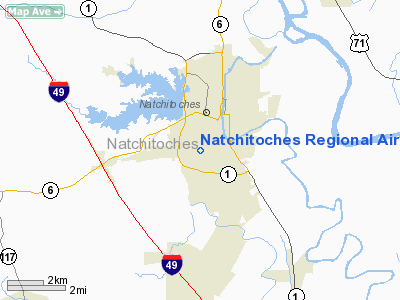
Natchitoches Regional Airport (ICAO: KIER, FAA LID: IER) is a city-owned public-use airport located two nautical miles (4 km) south of the central business district of Natchitoches, a city in Natchitoches Parish, Louisiana, United States.
Although most U.S. airports use the same three-letter location identifier for the FAA and IATA, this airport is assigned IER by the FAA but has no designation from the IATA.
The airport is the location of the plane crash which claimed the lives of Jim Croce and several others at 10:45 PM EDT on September 20, 1973, less than an hour after the end of Croce's last concert.
Facilities and aircraft
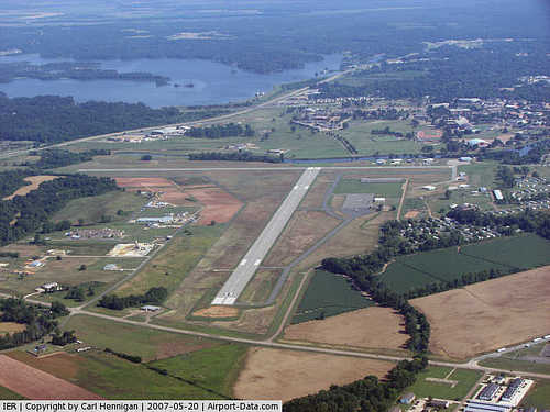
Natchitoches Regional Airport covers an area of 205 acres (83 ha) at an elevation of 121 feet (37 m) above mean sea level. It has two asphalt paved runways: 17/35 is 5,003 by 150 feet (1,525 x 46 m) and 7/25 is 4,000 by 100 feet (1,219 x 30 m).
For the 12-month period ending July 10, 2008, the airport had 15,715 aircraft operations, an average of 43 per day: 98% general aviation, 1% air taxi and 1% military. At that time there were 45 aircraft based at this airport: 82% single-engine, 9% multi-engine, 2% jet, 4% helicopter and 2% ultralight.
The above content comes from Wikipedia and is published under free licenses – click here to read more.
|
 |
(Click on the photo to enlarge) |
Location &
QuickFacts
|
FAA
Information Effective: |
2008-09-25 |
|
Airport
Identifier: |
IER |
|
Airport
Status: |
Operational |
|
Longitude/Latitude: |
093-05-56.8910W/31-44-08.5920N
-93.099136/31.735720 (Estimated) |
|
Elevation: |
121 ft / 36.88 m (Surveyed) |
|
Land: |
205 acres |
|
From
nearest city: |
2 nautical miles S of Natchitoches, LA |
|
Location: |
Natchitoches Parish, LA |
|
Magnetic Variation: |
04E (1995) |
Owner & Manager
|
Ownership: |
Publicly owned |
|
Owner: |
City Of Natchitoches |
|
Address: |
Po Box 37
Natchitoches, LA 71457 |
|
Phone number: |
318-357-3839 |
|
Manager: |
Larry Cooper |
|
Address: |
450 Wallenburg Drive
Natchitoches, LA 71457 |
|
Phone number: |
318-352-0994 |
Airport
Operations and Facilities
|
Airport
Use: |
Open to public |
|
Wind
indicator: |
Yes |
|
Segmented Circle: |
No |
|
Control
Tower: |
No |
|
Lighting
Schedule: |
DUSK-DAWN
MIRL RY 17/35 PRESET LOW INTST; TO INCR INTST & ACTVT MIRL RY 07/25 -
CTAF. RY 35 ODALS OPER LOW INTST CONTINUOUSLY; TO INCR INTST ACTVT -
CTAF. |
|
Beacon
Color: |
Clear-Green (lighted land airport) |
|
Landing
fee charge: |
No |
|
Sectional chart: |
Houston |
|
Region: |
ASW - Southwest |
|
Boundary
ARTCC: |
ZHU - Houston |
|
Tie-in
FSS: |
DRI - De Ridder |
|
FSS on
Airport: |
No |
|
FSS Toll
Free: |
1-800-WX-BRIEF |
|
NOTAMs
Facility: |
IER (NOTAM-d service avaliable) |
|
Federal Agreements: |
NGY3 |
Airport Communications
|
CTAF: |
122.800 |
|
Unicom: |
122.800 |
Airport Services
|
Fuel
available: |
100LLA1+
FUEL AVBL 24 HRS WITH CREDIT CARD. |
|
Airframe
Repair: |
MAJOR |
|
Power
Plant Repair: |
MAJOR |
|
Bottled
Oxygen: |
NONE |
|
Runway Information
Runway 07/25
|
Dimension: |
4000 x 100 ft / 1219.2 x 30.5 m |
|
Surface: |
ASPH, Good Condition |
|
Surface
Treatment: |
Aggregate Friction Seal Coat |
|
Weight Limit: |
Single wheel: 21000 lbs. |
|
Edge Lights: |
Medium |
|
|
Runway 07
|
Runway 25
|
|
Longitude: |
093-06-26.5360W |
093-05-41.5050W |
|
Latitude: |
31-44-16.1860N |
31-44-25.4510N |
|
Elevation: |
115.00 ft |
117.00 ft |
|
Alignment: |
76 |
127 |
|
Traffic
Pattern: |
Left |
Left |
|
Markings: |
Basic, Good Condition |
Basic, Good Condition |
|
Runway End
Identifier: |
No |
No |
|
Obstruction: |
85 ft trees, 2000.0 ft from runway, 21:1 slope to clear |
20 ft trees, 700.0 ft from runway, 125 ft right of
centerline, 25:1 slope to clear |
|
Runway 17/35
|
Dimension: |
5003 x 150 ft / 1524.9 x 45.7 m |
|
Surface: |
ASPH, Good Condition |
|
Weight Limit: |
Single wheel: 30000 lbs. |
|
Edge Lights: |
Medium |
|
|
Runway 17
|
Runway 35
|
|
Longitude: |
093-05-58.0440W |
093-05-44.4800W |
|
Latitude: |
31-44-22.8020N |
31-43-34.6660N |
|
Elevation: |
116.00 ft |
121.00 ft |
|
Alignment: |
127 |
127 |
|
ILS Type: |
|
LOCALIZER |
|
Traffic
Pattern: |
Left |
Left |
|
Markings: |
Non-precision instrument, Good Condition |
Non-precision instrument, Good Condition |
|
Crossing
Height: |
40.00 ft |
45.00 ft |
|
VASI: |
4-light PAPI on left side |
4-light PAPI on left side |
|
Visual
Glide Angle: |
3.00° |
3.00° |
|
Approach
lights: |
|
ODALS |
|
Runway End
Identifier: |
|
Yes |
|
Obstruction: |
51 ft trees, 1610.0 ft from runway, 250 ft left of
centerline, 27:1 slope to clear |
60 ft trees, 2400.0 ft from runway, 36:1 slope to clear |
|
Radio Navigation Aids
|
ID |
Type |
Name |
Ch |
Freq |
Var |
Dist |
|
POE1 |
FAN MARKER |
North |
|
|
07E |
38.1 nm |
|
POE |
FAN MARKER |
South |
|
|
07E |
45.6 nm |
|
IE |
NDB |
Campi |
|
407.00 |
04E |
4.8 nm |
|
MMY |
NDB |
Many |
|
272.00 |
04E |
24.7 nm |
|
IFJ |
NDB |
Winnfield |
|
402.00 |
04E |
26.4 nm |
|
JBL |
NDB |
Hodge |
|
256.00 |
04E |
33.8 nm |
|
MSD |
NDB |
Mansfield |
|
414.00 |
04E |
39.3 nm |
|
VED |
NDB |
Leesville |
|
247.00 |
04E |
40.1 nm |
|
GUV |
NDB |
Gator |
|
359.00 |
05E |
42.8 nm |
|
TUF |
NDB |
Stuckey |
|
350.00 |
03E |
48.1 nm |
|
SWB |
VOR/DME |
Sawmill |
84Y |
113.75 |
02E |
25.8 nm |
|
FXU |
VORTAC |
Polk |
021X |
108.40 |
05E |
38.0 nm |
|
AEX |
VORTAC |
Alexandria |
108X |
116.10 |
03E |
42.1 nm |
|
EMG |
VORTAC |
Elm Grove |
049X |
111.20 |
07E |
47.3 nm |
Remarks
-
GCO AVBL ON
135.075 THRU FORT POLK APCH-4 CLICKS AND DERIDDER FSS-6 CLICKS.
Based Aircraft
|
Aircraft based
on field: |
45 |
|
Single Engine
Airplanes: |
37 |
|
Multi Engine
Airplanes: |
4 |
|
Jet Engine
Airplanes: |
1 |
|
Helicopters: |
2 |
|
Ultralights: |
1 |
Operational Statistics
Time Period: 2006-08-03 - 2007-08-02
|
Aircraft
Operations: |
286/Week |
|
Air Taxi: |
1.0% |
|
General
Aviation Local: |
73.7% |
|
General
Aviation Itinerant: |
24.6% |
|
Military: |
0.7% |
Natchitoches Regional Airport
Address:
Natchitoches Parish, LA
Tel:
318-357-3839, 318-352-0994
Images
and information placed above are from
http://www.airport-data.com/airport/IER/
We
thank them for the data!
|
General Info |
| Country |
United
States |
| State |
LOUISIANA |
| FAA ID |
IER
|
| Latitude |
31-44-08.592N |
|
Longitude |
093-05-56.891W |
|
Elevation |
121 feet
|
| Near
City |
NATCHITOCHES |
We don't guarantee the information is fresh and accurate. The data may
be wrong or outdated.
For more up-to-date information please refer to other sources.
|
|


