|
|
 | |
AAF Navigator School patch, 1943 |
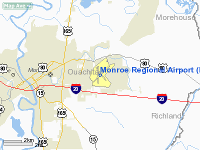
Monroe Regional Airport (IATA: MLU, ICAO: KMLU, FAA LID: MLU) is a public use airport in Ouachita Parish, Louisiana, United States. The airport is owned by the City of Monroe and is located three nautical miles (6 km) east of its central business district.
The airport is advertised as the birthplace of Delta Air Lines; the airport's logo is a variant on the Delta logo. History
During World War II, the United States Army Air Force Flying Training Command used the airport as a cadet training center beginning in August 1942.
The airport was named Selman Army Airfield, named after a Navy Pilot, Lieutenant Augustus J. Selman, U.S.N., a native of Monroe, LA, died at Norfolk, VA, on November 28, 1921, of injuries received in an airplane crash in the line of duty
The Army Air Force Pre-Flight School (Bomber-Navigation) transferred to Selman AAF from Maxwell Field, Alabama. The remaining elements of the Advanced Navigation School arrived from Turner Field, Georgia on September 14. Selman Field was the largest navigation school in the United States in its time and the nation's only complete navigation courseâfrom start to finishâduring World War II. Of the hundreds of fields that were operated by the Army Air Forces, it was only at Selman that a cadet could get his entire trainingâpre-flight and advancedâand wind up with a commission and navigators wings without ever leaving the field. Over 15,000 navigators were trained at Selman Field, who flew in every theater of operations during the war.
The vast majority of aircraft flown at Selman AAF were Beech C-45s, also known as the AT-7. BT-13s were flown for basic flying training, and TC-47 and TC-46s were used beginning in late 1944.
It closed on until 1 September 1945. After that Selman AAF was used as a separation center for returning overseas personnel until being inactivated on 31 May 1946. The airport was returned to civil control on 31 July 1946
Facilities and aircraft
Monroe Regional Airport covers an area of 2,660 acres (1,076 ha) at an elevation of 79 feet (24 m) above mean sea level. It has three asphalt paved runways: 4/22 is 7,507 by 150 feet (2,288 x 46 m); 14/32 is 5,000 by 150 feet (1,524 x 46 m); 18/36 is 5,001 by 150 feet (1,524 x 46 m).
In 2009 Lincoln Builders of Ruston started construction on a new nearly 60,000-square-foot (5,600 m) terminal scheduled to be completed in 2011.
For the 12-month period ending April 30, 2008, the airport had 44,706 aircraft operations, an average of 122 per day: 66% general aviation, 14% air taxi, 11% scheduled commercial and 9% military. At that time there were 93 aircraft based at this airport: 69% single-engine, 19% multi-engine, 8% jet and 4% helicopter.
Airlines and destinations
| Airlines |
Destinations |
| American Eagle |
Dallas/Fort Worth |
| Continental Connection operated by Colgan Air |
Houston-Intercontinental |
| Continental Express operated by ExpressJet Airlines |
Houston-Intercontinental |
| Delta Connection operated by Atlantic Southeast Airlines |
Atlanta, Memphis |
| Delta Connection operated by Pinnacle Airlines |
Memphis |
The above content comes from Wikipedia and is published under free licenses – click here to read more.
Location &
QuickFacts
|
FAA
Information Effective: |
2008-09-25 |
|
Airport
Identifier: |
MLU |
|
Airport
Status: |
Operational |
|
Longitude/Latitude: |
092-02-15.6760W/32-30-39.1160N
-92.037688/32.510866 (Estimated) |
|
Elevation: |
79 ft / 24.08 m (Surveyed) |
|
Land: |
2660 acres |
|
From
nearest city: |
3 nautical miles E of Monroe, LA |
|
Location: |
Ouachita Parish, LA |
|
Magnetic Variation: |
03E (1995) |
Owner & Manager
|
Ownership: |
Publicly owned |
|
Owner: |
City Of Monroe |
|
Address: |
Po Box 123
Monroe, LA 71210 |
|
Phone number: |
318-329-2200 |
|
Manager: |
Cleve Norrell |
|
Address: |
5400 Operations Rd
Monroe, LA 71203 |
|
Phone number: |
318-329-2461 |
Airport
Operations and Facilities
|
Airport
Use: |
Open to public |
|
Wind
indicator: |
Yes |
|
Segmented Circle: |
Yes |
|
Control
Tower: |
Yes |
|
Lighting
Schedule: |
SS-SR
WHEN ATCT CLSD ACTVT HIRL RY 04/22, MIRL RY 14/32, TWY LGTS, MALSR RYS
04 & 22, - CTAF.
PAPI RYS
04, 22, 14 & 32 OPERATES CONTINUOUSLY. |
|
Beacon
Color: |
Clear-Green (lighted land airport) |
|
Landing
fee charge: |
No |
|
Sectional chart: |
Memphis |
|
Region: |
ASW - Southwest |
|
Boundary
ARTCC: |
ZFW - Fort Worth |
|
Tie-in
FSS: |
DRI - De Ridder |
|
FSS on
Airport: |
No |
|
FSS Toll
Free: |
1-800-WX-BRIEF |
|
NOTAMs
Facility: |
MLU (NOTAM-d service avaliable) |
|
Certification type/date: |
I B S 05/1973
RY 18/36, TWYS J, E BTN RYS 18/36 AND 04/22, TWY A FROM RY 14 TO TWY C
NOT AVBL FOR ACR OPNS WITH OVER 9 PSGR SEATS. |
|
Federal Agreements: |
NGPY |
Airport Communications
|
CTAF: |
118.900 |
|
Unicom: |
122.950 |
Airport Services
|
Fuel
available: |
100LLA |
|
Airframe
Repair: |
MAJOR |
|
Power
Plant Repair: |
MAJOR |
|
Bottled
Oxygen: |
NONE |
|
Bulk
Oxygen: |
HIGH |
|
Runway Information
Runway 04/22
|
Dimension: |
7507 x 150 ft / 2288.1 x 45.7 m |
|
Surface: |
ASPH, Good Condition |
|
Surface
Treatment: |
Saw-cut or plastic Grooved |
|
Weight Limit: |
Single wheel: 75000 lbs.
Dual wheel: 170000 lbs.
Dual tandem wheel: 290000 lbs. |
|
Edge Lights: |
High |
|
|
Runway 04 |
Runway 22 |
|
Longitude: |
092-02-44.3650W |
092-01-42.3450W |
|
Latitude: |
32-30-13.8490N |
32-31-06.3450N |
|
Elevation: |
76.00 ft |
75.00 ft |
|
Alignment: |
45 |
127 |
|
ILS Type: |
ILS |
ILS |
|
Traffic
Pattern: |
Left |
Left |
|
Markings: |
Precision instrument, Good Condition |
Precision instrument, Good Condition |
|
Crossing
Height: |
50.00 ft |
54.00 ft |
|
VASI: |
4-light PAPI on left side |
4-light PAPI on left side |
|
Visual
Glide Angle: |
3.00° |
3.00° |
|
RVR
Equipment: |
touchdown |
|
|
Approach
lights: |
MALSR |
MALSR |
|
Decleard
distances: |
Take off run available 7507.00 ft
Take off distance available 7507.00 ft
Actual stop distance available 7507.00 ft
Landing distance available 7507.00 ft |
Take off run available 7507.00 ft
Take off distance available 7507.00 ft
Actual stop distance available 7507.00 ft
Landing distance available 7507.00 ft |
|
Runway 14/32
|
Dimension: |
5000 x 150 ft / 1524.0 x 45.7 m |
|
Surface: |
ASPH, Fair Condition |
|
Weight Limit: |
Single wheel: 75000 lbs.
Dual wheel: 170000 lbs.
Dual tandem wheel: 290000 lbs. |
|
Edge Lights: |
Medium |
|
|
Runway 14 |
Runway 32 |
|
Longitude: |
092-02-29.8280W |
092-01-52.3140W |
|
Latitude: |
32-30-59.3940N |
32-30-21.4860N |
|
Elevation: |
79.00 ft |
76.00 ft |
|
Alignment: |
127 |
127 |
|
Traffic
Pattern: |
Left |
Left |
|
Markings: |
Non-precision instrument, Fair Condition |
Non-precision instrument, Fair Condition |
|
Crossing
Height: |
50.00 ft |
50.00 ft |
|
Displaced
threshold: |
301.00 ft |
0.00 ft |
|
VASI: |
4-light PAPI on left side |
4-light PAPI on left side |
|
Visual
Glide Angle: |
3.00° |
3.00° |
|
Runway End
Identifier: |
Yes |
Yes |
|
Obstruction: |
50 ft trees, 1700.0 ft from runway, 200 ft left of
centerline, 30:1 slope to clear |
, 50:1 slope to clear |
|
Decleard
distances: |
Take off run available 5000.00 ft
Take off distance available 5000.00 ft
Actual stop distance available 5000.00 ft
Landing distance available 4699.00 ft |
Take off run available 5000.00 ft
Take off distance available 5000.00 ft
Actual stop distance available 5000.00 ft
Landing distance available 5000.00 ft |
|
Runway 18/36
|
Dimension: |
5001 x 150 ft / 1524.3 x 45.7 m |
|
Surface: |
ASPH, Good Condition |
|
Weight Limit: |
Single wheel: 60000 lbs.
Dual wheel: 75000 lbs.
Dual tandem wheel: 130000 lbs. |
|
|
Runway 18 |
Runway 36 |
|
Longitude: |
092-02-23.5950W |
092-02-23.6240W |
|
Latitude: |
32-31-01.1020N |
32-30-11.6230N |
|
Elevation: |
79.00 ft |
76.00 ft |
|
Alignment: |
127 |
0 |
|
Traffic
Pattern: |
Left |
Left |
|
Markings: |
Basic, Fair Condition |
Basic, Fair Condition |
|
Obstruction: |
46 ft trees, 2100.0 ft from runway, 375 ft right of
centerline, 41:1 slope to clear |
58 ft trees, 1650.0 ft from runway, 25:1 slope to clear |
|
Decleard
distances: |
Take off run available 5001.00 ft
Take off distance available 5001.00 ft
Actual stop distance available 5001.00 ft
Landing distance available 5001.00 ft |
Take off run available 5001.00 ft
Take off distance available 5001.00 ft
Actual stop distance available 5001.00 ft
Landing distance available 5001.00 ft |
|
Radio Navigation Aids
|
ID |
Type |
Name |
Ch |
Freq |
Var |
Dist |
|
MRK |
NDB |
Molly Ridge |
|
338.00 |
02E |
14.8 nm |
|
BQP |
NDB |
Bastrop |
|
329.00 |
03E |
16.6 nm |
|
ROQ |
NDB |
Ruston |
|
368.00 |
03E |
28.5 nm |
|
TUF |
NDB |
Stuckey |
|
350.00 |
03E |
28.6 nm |
|
JBL |
NDB |
Hodge |
|
256.00 |
04E |
39.6 nm |
|
IFJ |
NDB |
Winnfield |
|
402.00 |
04E |
45.6 nm |
|
BLE |
NDB |
Lake Providence |
|
278.00 |
03E |
47.0 nm |
|
SWB |
VOR/DME |
Sawmill |
84Y |
113.75 |
02E |
45.8 nm |
|
MLU |
VORTAC |
Monroe |
119X |
117.20 |
03E |
0.4 nm |
Remarks
-
TWY E EAST OF RWY
04/22 RESTRICTED TO ACFT WITH WINGSPAN UNDER 90'.
-
TWY A CLSD TO
ACFT OVER 12500 LBS EAST OF RY 18 TO TWY C.
Based Aircraft
|
Aircraft based
on field: |
93 |
|
Single Engine
Airplanes: |
64 |
|
Multi Engine
Airplanes: |
18 |
|
Jet Engine
Airplanes: |
7 |
|
Helicopters: |
4 |
Major Carriers Serving
This Airport
|
Atlantic Southeast Airlines |
43.8% |
|
American Eagle Airlines Inc. |
33.9% |
|
Expressjet Airlines Inc. |
22.3% |
Most Popular
Destinations
|
Hartsfield - Jackson Atlanta Intl (ATL) |
43.8% |
|
Dallas/fort Worth Intl (DFW) |
33.9% |
|
George Bush Intercontinental/houston (IAH) |
22.3% |
Most Popular Aircraft
|
N329AE |
2.9% |
|
N263AE |
2.7% |
|
N238AE |
2.6% |
|
N324AE |
2.5% |
|
N266AE |
2.1% |
|
N323AE |
2.1% |
|
N394AE |
2.1% |
|
N384AE |
2.0% |
|
N313AE |
1.8% |
|
N340RC |
1.7% |
Operational Statistics
Time Period: 2007-05-02 - 2008-04-30
|
Aircraft
Operations: |
123/Day |
|
Commerical: |
11.4% |
|
Air Taxi: |
14.3% |
|
General
Aviation Local: |
20.6% |
|
General
Aviation Itinerant: |
45.2% |
|
Military: |
8.5% |
Monroe Regional Airport
Address:
Ouachita Parish, LA
Tel:
318-329-2200, 318-329-2461
Images
and information placed above are from
http://www.airport-data.com/airport/MLU/
We
thank them for the data!
|
General Info |
| Country |
United
States |
| State |
LOUISIANA |
| FAA ID |
MLU
|
| Latitude |
32-30-39.116N |
|
Longitude |
092-02-15.676W |
|
Elevation |
79 feet
|
| Near
City |
MONROE
|
We don't guarantee the information is fresh and accurate. The data may
be wrong or outdated.
For more up-to-date information please refer to other sources.
|
|