|
 |
|
||||
|
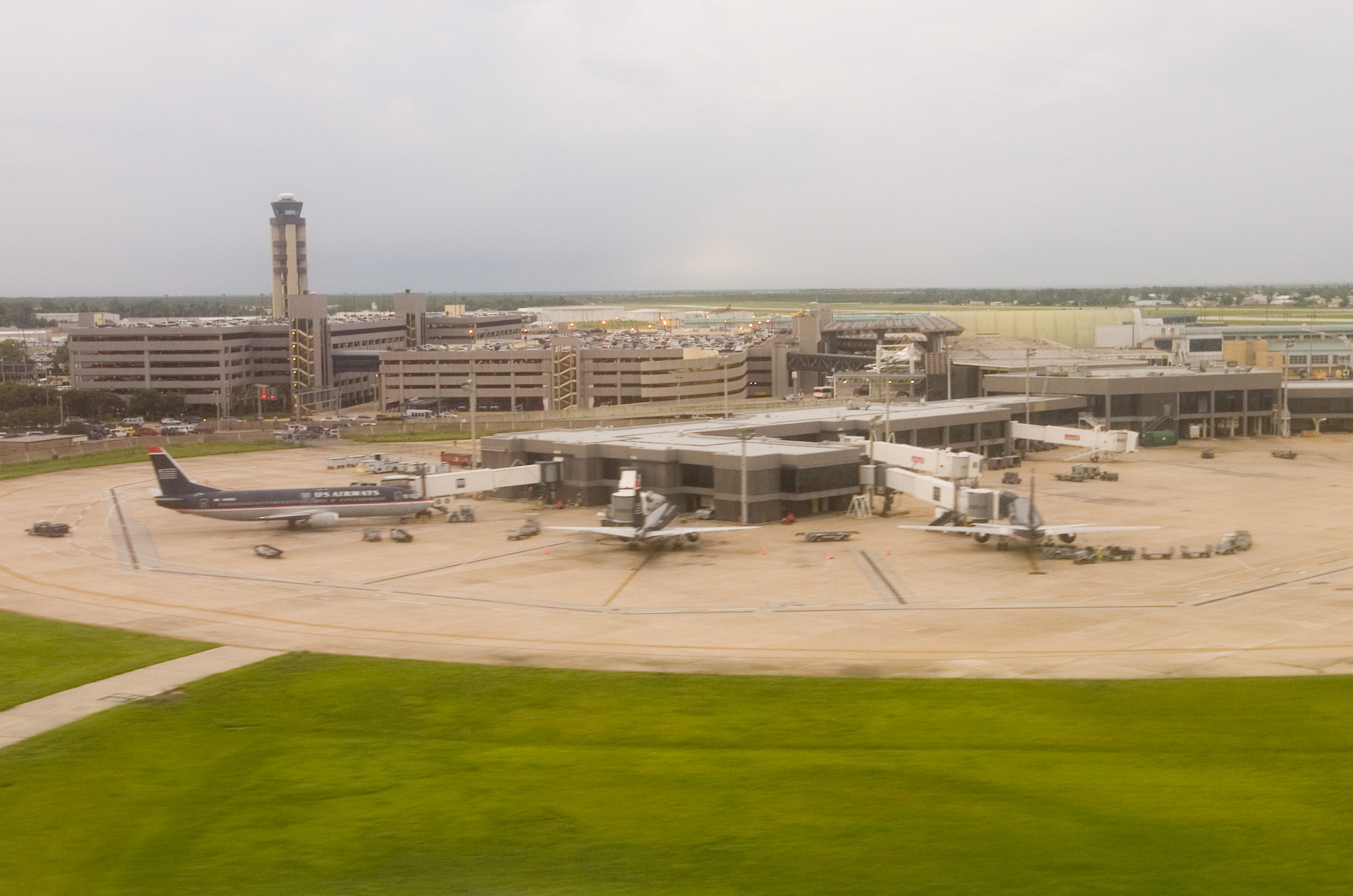
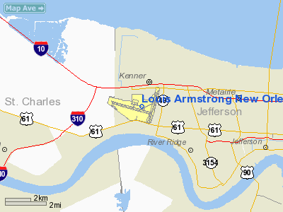
Louis Armstrong New Orleans International Airport (IATA: MSY, ICAO: KMSY, FAA LID: MSY) is a public use airport in Jefferson Parish, Louisiana, United States. It is owned by the City of New Orleans and is located 10 nautical miles (19 km) west of its central business district. The airport's address is 900 Airline Drive in Kenner, Louisiana. A small portion of Runway 10/28 is located in unincorporated St. Charles Parish. Armstrong International is the primary commercial airport for the New Orleans metropolitan area and southeast Louisiana. The airport was formerly known as Moisant Field, and it is also known as Louis Armstrong International Airport and New Orleans International Airport. Sitting at an average of 4.5 feet (1.4 m) above sea level, MSY is the 2nd lowest-lying international airport in the world, behind only Amsterdam's Schiphol International Airport in the Netherlands, which lies eleven feet below sea level. Prior to Hurricane Katrina, MSY served 9.7 million passengers per year, nearly all of them non-connecting. In 2009, it served 7,781,678 passengers, representing a decrease of 2.3% over the previous year. In February 2008, U.S. News And World Report ranked the travel experience at MSY 4th of the 47 busiest United States airports based upon the relatively small number of flight delays and frequently lower onboard flight loads. Louis Armstrong New Orleans International Airport was once a major gateway for Latin American travel from the United States. That travel now mostly goes through other cities which serve as hubs for international legacy airlines. MSY opened after World War II, replacing the older New Orleans Lakefront Airport (which kept the NEW and KNEW airport codes and now serves general aviation) as the city's main airport. MSY was renamed in 2001 after Louis Armstrong, a famous jazz musician from New Orleans. The National Weather Service forecast office for the area was once located at MSY, but has moved to the suburb of Slidell, and now uses the non-airport codes LIX and KLIX. HistoryThe airport was originally named after daredevil aviator John Moisant, who died in 1910 in an airplane crash on this land (which was devoted to farming at the time). Its IATA code MSY was derived from Moisant Stock Yards, as Lakefront Airport retained the "NEW" code. Plans for Moisant Field were begun in 1940, as evidence mounted that New Orleans' older Shushan Airport (New Orleans Lakefront Airport) was in need of expansion or replacement. With the advent of World War II the land became a government air base. It was returned to civilian control after the war, and commercial service began at Moisant Field in May 1946. On September 19, 1947, the airport was temporarily shut down as it was submerged under two feet of water in the wake of the 1947 Hurricane's impact. Starting in 1946, and for the next thirteen years, passengers arrived and departed from a large, hangar-like makeshift structure, until a new main terminal complex debuted in 1959 towards the end of Mayor DeLesseps "Chep" Morrison's administration. The core of this structure still forms much of the present day facility. On November 16, 1959, National Airlines Flight 967, a Douglas DC-7 flying from Tampa to New Orleans, crashed into the Gulf of Mexico. During the administration of Morrison's successor, Vic Schiro, formal government-sponsored studies were undertaken to evaluate the feasibility of relocating Louis Armstrong New Orleans International Airport to a new site, contemporaneous with similar efforts that were ultimately successful in Houston (George Bush Intercontinental Airport) and Dallas (Dallas-Fort Worth International Airport). This attempt got as far as recommending a site in New Orleans East; a man-made island was to be created south of I-10 and north of U.S. Route 90 in a bay of Lake Pontchartrain. However, in the early 1970s it was decided that the current airport should be expanded instead, leading to the construction of a lengthened main terminal ticketing area, an airport access road linking the terminal to I-10, and the present-day Concourses A and B. New Orleans Mayor Sidney Barthelemy, in office from 1986 to 1994, later reintroduced the idea of building a new international airport for the city, with consideration given to other sites in New Orleans East, as well as on the Northshore in suburban St. Tammany Parish. Only a couple months before Hurricane Katrina's landfall, Mayor Ray Nagin again proposed a new airport for New Orleans, this time to the west in Montz, Louisiana. These initiatives met with the same fate as 1960s-era efforts in new airport building for New Orleans. Historically, Eastern Air Lines provided extensive service from MSY, including Boeing 727 Whisperjet service to Dallas, Tampa, and Miami, as well as to New York City and Atlanta. Utilizing such aircraft as 727s, Douglas DC-8s, and DC-10s, National Airlines at different times served Miami, Amsterdam, Tampa, Houston, Las Vegas, Los Angeles, San Diego and San Francisco. Through 1979, Southern Airways Douglas DC-9s frequented Armstrong International, a busy stop on its regional short-haul network. Delta Air Lines was another leading carrier at MSY, and for years carried more passengers out of New Orleans than any other airline. Its nonstop jet service to New York, Chicago and Los Angeles from New Orleans was advertised for decades on a prominent billboard sited on Canal Street downtown. Southwest Airlines now carries the most passengers in and out of New Orleans. MSY was also the hub for short-lived Pride Air, an airline which operated for three months in 1985 using Boeing 727 aircraft. On July 11, 2001, the airport was renamed after jazz musician Louis Armstrong in honor of the centennial of his birth. Pan Am Flight 759On July 9, 1982, Pan Am Flight 759, en route from Miami to Las Vegas, departed New Orleans International. The Boeing 727-200 plane took off from the east-west runway (Runway 10/28) traveling east but never gained an altitude higher than 150 feet (46 m). The plane traveled 4,610 feet (1405 m) beyond the end of Runway 10, hitting trees along the way, until crashing into a residential neighborhood. A total of 153 people were killed (all 145 on board and 8 on the ground). The crash was at the time the second-deadliest civil aviation disaster in U.S. history. The National Transportation Safety Board determined the probable cause was the aircraft's encounter with a microburst-induced wind shear during the liftoff. This atmospheric condition created a downdraft and decreasing headwind forcing the plane downward. Modern wind shear detection equipment protecting flights from such conditions is now in place both onboard planes and at most commercial airports, including Armstrong International. Hurricane KatrinaThe airport was closed to commercial air traffic on August 28, 2005, shortly before Hurricane Katrina struck New Orleans, and it remained closed as floods affected the city. The Associated Press reported on August 31 that MSY would receive humanitarian flights, and that the airport "has no significant airfield damage and had no standing water in aircraft movement areas", although the airport did, as the article put it, "[sustain] damage to its roofs, hangars and fencing." In early September, the airport opened only to military aircraft and humanitarian flights, and served as a staging center for evacuees. The airport reopened to commercial flights on September 13, 2005. February 2006 tornadoAt about 2:30 EST in the morning on February 3, 2006, a tornado touched down on the grounds of MSY. The damage from the tornado was significant but primarily confined to Concourse C, where American, United, AirTran Airways, and international arrivals were based. Many temporary repairs dating from Hurricane Katrina failed, including one roof patch, forcing airlines based in the concourse to relocate operations to vacant gates. Jetways and other ground equipment also sustained damage. As of late 2006, all of this had been repaired. Post-Katrina capacity restorationMSY reopened to commercial flights on September 13, 2005, with four flights operated by Delta Air Lines to Atlanta and a Northwest Airlines flight to Memphis. Slowly, service from other carriers began to resume, with limited service offered by Southwest Airlines, Continental Airlines, and American Airlines.
Eventually, all carriers announced their return to MSY, with the exception of America West Airlines (which merged into US Airways two weeks later) and international carrier TACA. In early 2006 Continental Airlines became the first airline to return to pre-Katrina flight frequency levels, and in September 2006, to pre-Katrina seat capacity levels. MSY served 7,781,678 passengers in 2009, or 80% of the all time high of 9,733,179 passengers who used Armstrong International in 2004. As of September 2009, MSY's operations will be at ???% of their pre-Katrina status, measured by airlines' daily seat-count. Eighty-one percent of daily roundtrip flights will have been restored at that point, as well as 83% of the number of domestic cities served daily (scheduled) nonstop and 50% of international cities served (scheduled) nonstop. In May 2010, AirTran announced new daily non-stop service to its hub in Milwaukee utilizing Boeing 717 aircraft and beginning on October 7, 2010. This route marks MSY's first all-new city addition since 1998. Incentives to airlinesOn November 21, 2006; the New Orleans Aviation Board approved an air service initiative to promote increased service to Armstrong International:
On January 17, 2008; the city's aviation board voted on an amended incentive program which waives landing fees for the first two airlines to fly nonstop into a city not presently served from the airport. Under the new ruling, landing fees will be waived for up to two airlines flying into an "underserved destination airport." The incentive previously referred to service to a "new destination airport." The airport is also continuing its incentive to airlines that reach 85% of their pre-Katrina flight frequencies. Incentives to passengersIn November 2006, the airport opened a "cell phone lot" at the corner of Airline Drive and Hollandey Street across from the Airport Access Road to allow people picking up arriving passengers to wait until an arriving passenger calls to say they are ready for pickup. Also, on December 6, 2006 Armstrong International launched an $8 million maintenance campaign to clean and improve the terminal environment. Dubbed Music To Your Eyes, the campaign is designed to transform the airport into a more visitor-friendly facility, with improvements to lighting, cleanliness, seating, baggage claim maintenance, curbside congestion, and designated smoking areas. Facilities and aircraftLouis Armstrong New Orleans International Airport covers an area of 1,500 acres (607 ha) at an elevation of 4 feet (1 m) above mean sea level. It has three runways: 10/28 is 10,104 by 150 feet (3,080 x 46 m) with a concrete surface; 1/19 is 7,001 by 150 feet (2,134 x 46 m) with a concrete surface; 6/24 is 3,570 by 150 feet (1,088 x 46 m) with an asphalt surface. For the 12-month period ending December 31, 2007, the airport had 129,228 aircraft operations, an average of 354 per day: 58% scheduled commercial, 21% general aviation and 19% air taxi and 1% military. At that time there were 19 aircraft based at this airport: 21% single-engine, 21% multi-engine, 42% jet and 16% helicopter. International servicesArmstrong International's Concourse C, located in the airport's West Terminal, contains a fully enclosed US Customs, Immigration, and FIS facility. The majority of the concourse's 15 gates offer direct access to this area and are thus capable of accepting foreign arrivals from all over the world, on aircraft as large as Boeing 747-400s. Past international servicesBefore Hurricane Katrina (2005), regularly scheduled international services from Armstrong International were provided by Air Canada to Toronto and Grupo TACA to San Pedro Sula in Honduras. Historically, MSY has hosted routes to nearly thirty nonstop international destinations, several of them intercontinental. In the early 1980s, the city was a stop on the British Airways flight between London and Mexico City. The Lockheed L1011 aircraft used for the route landed in New Orleans to pick up passengers and fuel. National Airlines also flew nonstop to Amsterdam from MSY, using DC-10 aircraft. At different times Eastern Air Lines offered nonstop service to Caracas, Venezuela and Panama City, Panama. Continental Airlines offered flights to Mexico City and Cancun in the 1980s, as did AeroMexico. TWA offered Mexico City service with McDonnell Douglas MD-80 equipment in the 1990s and into the early 2000s. Throughout the 1970s, '80s, and '90s Aviateca, LACSA, TAN/SAHSA and TACA provided both nonstop and same-plane direct services to several Central American destinations, including Belize City, Guatemala City, San Pedro Sula, Tegucigalpa, La Ceiba, Roatan, San Salvador, Merida, Cancun, and San Jose. TACA was even headquartered in New Orleans, before returning its headquarters to Central America in 1982. The networks of essentially all of the aforementioned defunct Central American carriers have, as of today, been absorbed into that of Grupo TACA. Twice weekly seasonal New Orleans to Montego Bay nonstops via the Jamaica Shuttle/Casino Express (typically operated by chartered Boeing 727-200's or 737-300's) operated during most of the 1990s and into the 2000s. Laker Airways operated twice weekly seasonal B727-200 flights between New Orleans and Freeport, Bahamas in the early 2000s. Vacation Express operated twice weekly seasonal charters between New Orleans and Cancun for several years using a mix of B727-200, B737-200, B737-300, and MD-80 equipment; This service was suspended after the company decided to concentrate on selling seats on scheduled flights instead of chartering aircraft. All international service into MSY was suspended while the FIS facility was closed post-Katrina. The facility reopened to an influx of chartered flights arriving from London, Manchester, Bournemouth, and Nottingham, UK - all carrying tourists in for Mardi Gras and set to depart aboard a cruise liner. Return of scheduled international serviceIn August 2009, City Skies Air announced nonstop service linking MSY with Cancun, Mexico as well as Tegucigalpa, Honduras and San Pedro Sula, Honduras. Flights were originally to be operated with Boeing 737-300s via the auspices of Swift Air. However, after a revamp of their website and operating phone number; on September 15, 2009, City Skies operated their first flight from New Orleans to Tegucigalpa, with a 737-400 provided by Xtra Airways. Currently no flights are operating, and the status of new flights resuming is unknown. On December 12, 2008, AeroMexico (and its regional subsidiary Aerolitoral) were granted USDOT permission to offer scheduled nonstop service between MSY and Mexico City. On April 7, 2009, it was announced that AeroMexico would begin 6-times weekly nonstop flights between New Orleans and Mexico City on July 6, 2009, with the service operated by Aerolitoral dba AeroMexico Connect. AeroMexico made several changes to its US network in the spring of 2010, and MSY-MEX service was reduced to an intermittent 2-3 times weekly frequency in March of that year. Aeromexico removed the route from their reservation system in June of 2010 and the last flight is scheduled to operate on July 26, 2010. On July 7, 2010, WestJet announced a winter seasonal 4-times weekly scheduled nonstop service between Toronto and New Orleans, utilizing Boeing 737 equipment and commencing on November 1, 2010. This development marks the first all-new international carrier to announce scheduled service to MSY since 1998. On July 14, 2010, Air Canada announced the resumption of daily nonstop service between Toronto and New Orleans, utilizing Bombardier CRJ-705 equipment (operated by Air Canada Jazz) with 2 classes of service. This route will start on October 30, 2010. TACA provided summer seasonal charter flights nonstop from MSY to San Pedro Sula, Honduras, with continuing service to San Salvador, El Salvador in June 2008. There has thus far been no indication as to when or if that carrier plans to return to MSY on a scheduled basis. Terminals and concoursesLouis Armstrong International has two terminals, East and West, connected by a central ticketing alley. Attached are four concourses, A, B, C, and D.
Concourse AConcourse A opened in 1975 and has 6 Gates: A1, A3, A5, A6, A7, A8. Concourse BConcourse B opened in 1975 and has 13 Gates: B1 - B13 International Concourse C
Excepting customs pre-cleared flights; all nonstop international arrivals are handled by Concourse C. This concourse also contains both common-use and overflow gates, available for infrequent services and charter flights as well. Concourse C opened in 1991 and has 15 Gates: C1 - C12, C14 - C16 Concourse DThe newest concourse, D, opened in 1997 and contains a Delta Air Lines Sky Club, the sole such airline club remaining in Armstrong. Concourse D is also undergoing a 6-gate expansion. Due to that construction, some flights by Concourse D tenants have been temporarily relocated to the overflow gates in the international arrivals concourse (C). Concourse D has 7 Gates: D1 - D6 and D8 Ground transportationBus service between the airport and downtown New Orleans is provided by Jefferson Transit bus E-2.[1] Airlines and destinations
Cargo Airlines
The above content comes from Wikipedia and is published under free licenses – click here to read more.
Runway InformationRunway 01/19
Runway 06/24
Runway 10/28
Radio Navigation Aids
Remarks
Based Aircraft
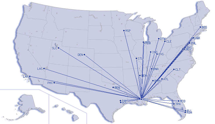
Major Carriers Serving This Airport
Most Popular Destinations
Most Popular Aircraft
Operational StatisticsTime Period: 2007-01-01 - 2007-12-31
Louis Armstrong New Orleans International Airport Address: Jefferson Parish, LA Tel: 504-658-4900, 504-628-2428 Images
and information placed above are from We thank them for the data!
We don't guarantee the information is fresh and accurate. The data may
be wrong or outdated.
|
|||||||||||||||||||||||||||||||||||||||||||||||||||||||||||||||||||||||||||||||||||||||||||||||||||||||||||||||||||||||||||||||||||||||||||||||||||||||||||||||||||||||||||||||||||||||||||||||||||||||||||||||||||||||||||||||||||||||||||||||||||||||||||||||||||||||||||||||||||||||||||||||||||||||||||||||||||||||||||||||||||||||||||||||||||||||||||||||||||||||||||||||||||||||||||||||||||||||||||||||||||||||||||||||||||||||||||||||||||||||||||||||||||||||||||||||||||||||||||||||||||||||||||||||||||||||||||||||||||||||||||||||||||||||||||||||||||||||||||||||||||||||||||||||||||||||||||||||||||||||||||||||||||||||||||||||||||||||||||

 |
|
Copyright 2004-2026 © by Airports-Worldwide.com, Vyshenskoho st. 36, Lviv 79010, Ukraine Legal Disclaimer |