 |
|
| Lakefront Airport |
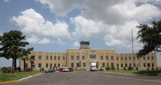 |
| Lakefront Airport, main terminal, 2010 |
| IATA: NEW â ICAO: KNEW â FAA LID: NEW |
| Summary |
| Airport type |
Public |
| Owner |
Louisiana Division of Administration |
| Serves |
New Orleans, Louisiana |
| Elevation AMSL |
8 ft / 2 m |
| Coordinates |
30°02â²33â³N 090°01â²42â³W / 30.0425°N 90.02833°W / 30.0425; -90.02833 |
| Runways |
| Direction |
Length |
Surface |
| ft |
m |
| 9/27 |
3,113 |
949 |
Asphalt |
| 18L/36R |
3,697 |
1,127 |
Asphalt |
| 18R/36L |
6,867 |
2,093 |
Asphalt |
| Statistics (2006) |
| Aircraft operations |
29,676 |
| Based aircraft |
97 |
| Source: Federal Aviation Administration |
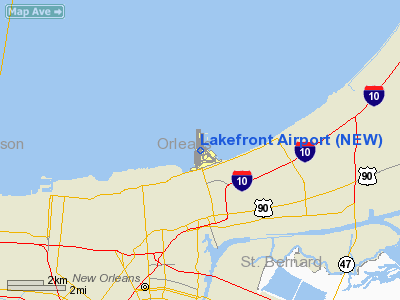
Lakefront Airport (IATA: NEW, ICAO: KNEW, FAA LID: NEW) is a public use airport located four nautical miles (7 km) northeast of the central business district of New Orleans, in Orleans Parish, Louisiana, United States. It is owned by the Louisiana Division of Administration.
Originally the major commercial airport in the New Orleans area, Lakefront Airport relinquished that role in 1946 when commercial airline service began from Louis Armstrong International Airport, a significantly larger facility located in the nearby suburb of Kenner. Lakefront Airport continues to serve as a general aviation airport with charter, private, and occasional military operations taking place. The terminal building's interior retains much of its original lavish 1930s decoration, and the art deco exterior, obscured for decades by a "bomb-proof" facade installed after World War II, has recently been returned to its original appearance. The terminal building housed a restaurant frequented by nearby residents, the Walnut Room, but this has yet to reopen, post-Katrina. The sculpture installation in front of the terminal, "Fountain of the Winds" by Enrique Alferez, is a local landmark.
Lakefront Airport was damaged by hurricane-force winds and the storm surge of Hurricane Katrina in 2005, and a number of the hangers and outlying buildings were destroyed. While the airport soon resumed functioning, restoration of the terminal building and other facilites has been proceeding slowly. History
The airport was constructed in the mid 1930s by Huey Long on a man-made peninsula dredged by the Orleans Levee Board, jutting into Lake Pontchartrain on the Eastern New Orleans side of the Industrial Canal. It was originally named Shushan Airport after Levee Board president Abraham Shushan. The airport was inaugurated on 10 February 1934. Visitors noticed that every doorknob, window sill, countertop, and plumbing fixture either had the name or the initials of Abe Shushan. The airport was soon thereafter renamed New Orleans Airport, and was assigned the airport code "NEW", which it retains despite its current name.
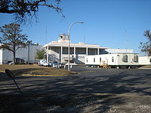 | |
Main terminal in late 2005, before restoration |
During World War II the airfield was used by the United States Army Air Force and housed the Tropical Weather School in 1945.
At the start of the 1960s thick concrete panels were added to the main terminal building to turn it into a Cold War era bomb shelter.
Lakefront Airport was badly damaged by storm surge during Hurricane Katrina in 2005. While the airport was quickly brought back to service, many facilities remained in temporary trailers for years.
Post-Katrina reconstruction at the airport has included restoration of the main terminal building's original Art Deco facade.
Facilities and aircraft
Lakefront Airport covers an area of 473 acres (191 ha) at an elevation of 8 feet (2 m) above mean sea level. It has three asphalt paved runways: 9/27 is 3,113 by 75 feet (949 x 23 m); 18L/36R is 3,697 by 75 feet (1,127 x 23 m); 18R/36L is 6,867 by 150 feet (2,093 x 46 m).
For the 12-month period ending December 31, 2006, the airport had 29,676 aircraft operations, an average of 81 per day: 86% general aviation, 7% military, 7% air taxi and <1% scheduled commercial, At that time there were 97 aircraft based at this airport: 65% single-engine, 29% multi-engine, 5% jet and 1% helicopter.
The above content comes from Wikipedia and is published under free licenses – click here to read more.
Location &
QuickFacts
|
FAA
Information Effective: |
2008-09-25 |
|
Airport
Identifier: |
NEW |
|
Airport
Status: |
Operational |
|
Longitude/Latitude: |
090-01-41.7000W/30-02-32.6000N
-90.028250/30.042389 (Estimated) |
|
Elevation: |
8 ft / 2.44 m (Surveyed) |
|
Land: |
473 acres |
|
From
nearest city: |
4 nautical miles NE of New Orleans, LA |
|
Location: |
Orleans Parish, LA |
|
Magnetic Variation: |
02E (1995) |
Owner & Manager
|
Ownership: |
Publicly owned |
|
Owner: |
La Division Of Administration |
|
Address: |
Room 202-adm Bldg
New Orleans, LA 70126 |
|
Phone
number: |
504-243-4000 |
|
Manager: |
R.w. Taylor
DIRECTOR OF AVIATION |
|
Address: |
6001 Stars & Stripes Blvd
New Orleans, LA 70126 |
|
Phone number: |
504-243-4010 |
Airport Operations and Facilities
|
Airport
Use: |
Open to public |
|
Wind
indicator: |
Yes |
|
Segmented Circle: |
Yes
SEGMENTED CIRCLE POOR CONDITION/VISIBILITY. |
|
Control
Tower: |
Yes |
|
Lighting
Schedule: |
DUSK-DAWN
MIRL RY 18R/36L AND TWY LGTS FOR TWYS A, B, D, E, F & H PRESET ON MED
INTST. |
|
Beacon
Color: |
Clear-Green (lighted land airport) |
|
Landing
fee charge: |
Yes |
|
Sectional chart: |
New Orleans |
|
Region: |
ASW - Southwest |
|
Boundary
ARTCC: |
ZHU - Houston |
|
Tie-in
FSS: |
DRI - De Ridder |
|
FSS on
Airport: |
No |
|
FSS Toll
Free: |
1-800-WX-BRIEF |
|
NOTAMs
Facility: |
NEW (NOTAM-d service avaliable) |
|
Federal Agreements: |
NGPY3 |
Airport Communications
|
CTAF: |
119.900 |
|
Unicom: |
122.950 |
Airport Services
|
Fuel
available: |
100LLA |
|
Airframe
Repair: |
MAJOR |
|
Power
Plant Repair: |
MAJOR |
|
Bottled
Oxygen: |
HIGH |
|
Bulk
Oxygen: |
HIGH |
|
Runway Information
Runway 09/27
|
Dimension: |
3113 x 75 ft / 948.8 x 22.9 m |
|
Surface: |
ASPH, Good Condition
FEW LOW SPOTS NEAR INTERSECTION OF RY 09/27-HOLDING WATER. |
|
Weight Limit: |
Single wheel: 50000 lbs.
Dual wheel: 80000 lbs.
Dual tandem wheel: 100000 lbs. |
|
Edge Lights: |
Medium
MIRL AVBL ON LOW INTST ONLY. |
|
|
Runway 09
|
Runway 27
|
|
Longitude: |
090-01-50.2232W |
090-01-14.8073W |
|
Latitude: |
30-02-13.3757N |
30-02-13.8169N |
|
Elevation: |
5.00 ft |
5.00 ft |
|
Alignment: |
89 |
127 |
|
Traffic
Pattern: |
Left |
Right |
|
Markings: |
Basic, Good Condition |
Basic, Good Condition |
|
Crossing
Height: |
40.00 ft |
40.00 ft |
|
VASI: |
4-light PAPI on left side |
4-light PAPI on right side |
|
Visual
Glide Angle: |
3.00° |
3.00° |
|
Runway End
Identifier: |
Yes |
|
|
Obstruction: |
4 ft berm, 267.0 ft from runway, 16:1 slope to clear |
14 ft road, 543.0 ft from runway, 161 ft right of
centerline, 24:1 slope to clear |
|
Decleard
distances: |
Take off run available 3113.00 ft
Take off distance available 3113.00 ft
Actual stop distance available 3113.00 ft
Landing distance available 3113.00 ft |
Take off run available 3113.00 ft
Take off distance available 3113.00 ft
Actual stop distance available 3113.00 ft
Landing distance available 3113.00 ft |
|
Runway 18L/36R
|
Dimension: |
3697 x 75 ft / 1126.8 x 22.9 m |
|
Surface: |
ASPH, Good Condition
FEW LOW SPOTS NEAR INTERSECTION OF RY 09/27-HOLDING WATER. |
|
Weight Limit: |
Single wheel: 35000 lbs.
Dual wheel: 55000 lbs.
Dual tandem wheel: 80000 lbs. |
|
Edge Lights: |
Medium
MIRL AVBL ON LOW INTST ONLY. |
|
|
Runway 18L
|
Runway 36R
|
|
Longitude: |
090-01-39.6142W |
090-01-39.0579W |
|
Latitude: |
30-03-00.6695N |
30-02-24.0735N |
|
Elevation: |
6.00 ft |
7.00 ft |
|
Alignment: |
127 |
127 |
|
Traffic
Pattern: |
Left |
Right |
|
Markings: |
Basic, Good Condition |
Basic, Good Condition |
|
Crossing
Height: |
0.00 ft |
45.00 ft |
|
VASI: |
|
4-light PAPI on left side |
|
Visual
Glide Angle: |
0.00° |
3.00° |
|
Runway End
Identifier: |
Yes |
Yes |
|
Obstruction: |
, 50:1 slope to clear |
54 ft bldg, 2035.0 ft from runway, 35 ft left of
centerline, 33:1 slope to clear |
|
Decleard
distances: |
Take off run available 3697.00 ft
Take off distance available 3697.00 ft
Actual stop distance available 3697.00 ft
Landing distance available 3697.00 ft |
Take off run available 3697.00 ft
Take off distance available 3697.00 ft
Actual stop distance available 3697.00 ft
Landing distance available 3697.00 ft |
|
Runway 18R/36L
|
Dimension: |
6867 x 150 ft / 2093.1 x 45.7 m |
|
Surface: |
ASPH, Good Condition
FEW LOW SPOTS NEAR INTERSECTION OF RY 09/27-HOLDING WATER. |
|
Surface
Treatment: |
Saw-cut or plastic Grooved |
|
Weight Limit: |
Single wheel: 60000 lbs.
Dual wheel: 175000 lbs.
Dual tandem wheel: 200000 lbs.
Dual dual tandem wheel: 350000 lbs. |
|
Edge Lights: |
Medium
MIRL AVBL ON LOW INTST ONLY. |
|
|
Runway 18R
|
Runway 36L
|
|
Longitude: |
090-01-47.7054W |
090-01-46.7001W |
|
Latitude: |
30-03-10.0171N |
30-02-02.0448N |
|
Elevation: |
6.00 ft |
6.00 ft |
|
Alignment: |
127 |
127 |
|
ILS Type: |
ILS/DME |
|
|
Traffic
Pattern: |
Right |
Left |
|
Markings: |
Precision instrument, Good Condition |
Non-precision instrument, Good Condition |
|
Crossing
Height: |
51.00 ft |
50.00 ft |
|
Displaced
threshold: |
228.00 ft |
820.00 ft |
|
VASI: |
4-light PAPI on left side |
4-light PAPI on left side |
|
Visual
Glide Angle: |
3.00° |
3.00° |
|
Runway End
Identifier: |
|
Yes |
|
Obstruction: |
6 ft pier, 300.0 ft from runway, 16:1 slope to clear
APCH RATIO 50:1 FM DSPLCD THR. |
77 ft wall, 2500.0 ft from runway, 580 ft right of
centerline, 29:1 slope to clear
APCH RATIO 32:1 AT DSPLCD THR; +77' SILO 2500'; 580' R.
+7 FT WALL 150 FT FM RY END. |
|
Decleard
distances: |
Take off run available 6880.00 ft
Take off distance available 6880.00 ft
Actual stop distance available 6880.00 ft
Landing distance available 6640.00 ft |
Take off run available 6880.00 ft
Take off distance available 6880.00 ft
Actual stop distance available 6880.00 ft
Landing distance available 6060.00 ft |
|
Radio Navigation Aids
|
ID |
Type |
Name |
Ch |
Freq |
Var |
Dist |
|
DEF |
NDB |
Slidell |
|
256.00 |
03E |
18.3 nm |
|
MS |
NDB |
Kinte |
|
338.00 |
03E |
19.4 nm |
|
FNA |
NDB |
Florenville |
|
371.00 |
03E |
24.9 nm |
|
MJD |
NDB |
Picayune |
|
276.00 |
01E |
33.4 nm |
|
AYI |
NDB |
Hanco |
|
221.00 |
03E |
38.6 nm |
|
HS |
NDB |
Hanco |
|
221.00 |
01E |
38.6 nm |
|
HMU |
VOR |
Hammond |
|
109.60 |
03E |
35.1 nm |
|
RQR |
VOR/DME |
Reserve |
045X |
110.80 |
02E |
29.3 nm |
|
PCU |
VOR/DME |
Picayune |
059X |
112.20 |
05E |
34.8 nm |
|
HRV |
VORTAC |
Harvey |
088X |
114.10 |
02E |
11.6 nm |
|
TBD |
VORTAC |
Tibby |
057X |
112.00 |
02E |
47.5 nm |
|
NEW |
VOT |
New Orleans Lakefront |
|
111.00 |
|
0.2 nm |
Remarks
-
PPR TO LND FOR
ACFT TRNSPG ANY ITEMS LISTED IN PART 175 TITLE 49.
-
HOLD SHORT SIGN
ON RY 09/27 AT INTXN RY 18R/36L UNLGTD.
-
TWY G CLSD WEST
OF RY 18R/36L INDEFLY.
-
WIND SOCK LGTS
OTS INDEFLY.
-
BIRDS ON & INVOF ARPT.
-
FLIGHT
NOTIFICATION SERVICE (ADCUS) AVAILABLE.
-
BOATS AS HIGH AS
80' PASS WITHIN 400' OF RWY 9, 18R & 18L THRS.
-
ARFF CAPABILITY
EQUIVALENT TO INDEX B.
-
PAEW ADJ AER 27
DALGT HRS.
Based Aircraft
|
Aircraft based
on field: |
97 |
|
Single Engine
Airplanes: |
63 |
|
Multi Engine
Airplanes: |
28 |
|
Jet Engine
Airplanes: |
5 |
|
Helicopters: |
1 |
Operational Statistics
Time Period: 2006-01-01 - 2006-12-31
|
Aircraft
Operations: |
82/Day |
|
Commerical: |
0.1% |
|
Air Taxi: |
7.0% |
|
General
Aviation Local: |
30.0% |
|
General
Aviation Itinerant: |
56.0% |
|
Military: |
6.9% |
Lakefront Airport
Address:
Orleans Parish, LA
Tel:
504-243-4000,
504-243-4010
Images
and information placed above are from
http://www.airport-data.com/airport/NEW/
We
thank them for the data!
|
General Info |
| Country |
United
States |
| State |
LOUISIANA |
| FAA ID |
NEW
|
| Latitude |
30-02-32.714N |
|
Longitude |
090-01-41.725W |
|
Elevation |
9 feet
|
| Near
City |
NEW
ORLEANS |
We don't guarantee the information is fresh and accurate. The data may
be wrong or outdated.
For more up-to-date information please refer to other sources.
|
|


