 |
|
Lake Charles Regional Airport |
| Lake Charles Regional Airport |
| IATA: LCH â ICAO: KLCH â FAA LID: LCH |
| Summary |
| Airport type |
Public |
| Owner |
Calcasieu Parish |
| Serves |
Lake Charles, Louisiana |
| Elevation AMSL |
15 ft / 5 m |
| Coordinates |
30°07â²34â³N 093°13â²24â³W / 30.12611°N 93.22333°W / 30.12611; -93.22333 |
| Website |
FlyLakeCharles.com |
| Runways |
| Direction |
Length |
Surface |
| ft |
m |
| 5/23 |
5,200 |
1,585 |
Asphalt |
| 15/33 |
6,500 |
1,981 |
Concrete |
| Statistics (2007) |
| Aircraft operations |
41,346 |
| Based aircraft |
202 |
| Source: Federal Aviation Administration |
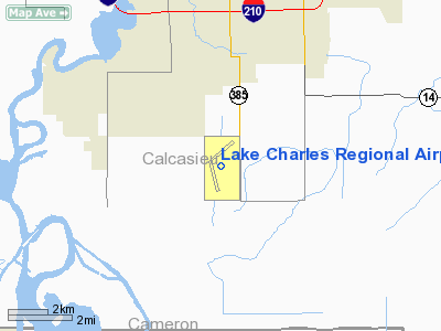
Lake Charles, LA, September 24, 2007 -- Federal Emergency Management Agency (FEMA) Transitional Field Office Director Jim Stark addressed a group of local, state and federal officials on the second anniversary of Hurricane Rita and the ground breaking for the new Lake Charles Regional Airport terminal, which was completed in 2009. The new facility replaced one destroyed by Hurricane Rita. FEMA provided more than $2.7 million for the project. Photo by Manuel Broussard/FEMA. Lake Charles Regional Airport (IATA: LCH, ICAO: KLCH, FAA LID: LCH) is a public use airport located five nautical miles (9 km) south of the central business district of Lake Charles, a city in Calcasieu Parish, Louisiana, United States. Owned by Calcasieu Parish, the airport serves approximately 375,000 people in the Lake Charles â Jennings combined statistical area.
The airport has two runways. They are oriented 5/23 and 15/33 and do not cross. The grounds are bounded by Lake Street to the West, Gauthier Road to the North, Highway 385 to the East, and Lincoln Road to the South. The entrance is off of Highway 385.
A new state-of-the-art terminal building was officially opened to the public in 2009. Built in the Louisiana plantation architectural style, it is a two story terminal with one concourse. In 2009, American Eagle began twice daily, non-stop service to Dallas-Fort Worth International Airport. Facilities and aircraft
Lake Charles Regional Airport covers an area of 1,878 acres (760 ha) at an elevation of 15 feet (5 m) above mean sea level. It has two runways: 5/23 is 5,200 by 100 feet (1,585 x 30 m) with an asphalt surface; 15/33 is 6,500 by 150 feet (1,981 x 46 m) with a concrete surface.
For the 12-month period ending December 31, 2007, the airport had 41,346 aircraft operations, an average of 113 per day: 48% general aviation, 33% air taxi, 19% military and <1% scheduled commercial, At that time there were 202 aircraft based at this airport: 19% single-engine, 8% multi-engine, 1% jet and 72% helicopter.
A large number of helicopters are based at LCH and serve both the petroleum industry in the Gulf and other purposes. A large marine spill operation is located on the southwest corner of the grounds. The property also includes a 300-acre industrial park which provides land leases to many businesses and individuals.
Airlines and scheduled destinations
| Airlines |
Destinations |
| American Eagle |
Dallas/Fort Worth |
| Continental Express operated by ExpressJet Airlines |
Houston-Intercontinental |
| Continental Express operated by Colgan Air |
Houston-Intercontinental |
The above content comes from Wikipedia and is published under free licenses – click here to read more.
|
 |
(Click on the photo to enlarge) |
Location &
QuickFacts
|
FAA
Information Effective: |
2008-09-25 |
|
Airport
Identifier: |
LCH |
|
Airport
Status: |
Operational |
|
Longitude/Latitude: |
093-13-24.3000W/30-07-33.9000N
-93.223417/30.126083 (Estimated) |
|
Elevation: |
15 ft / 4.57 m (Surveyed) |
|
Land: |
1878 acres |
|
From
nearest city: |
5 nautical miles S of Lake Charles, LA |
|
Location: |
Calcasieu Parish, LA |
|
Magnetic Variation: |
03E (2005) |
Owner & Manager
|
Ownership: |
Publicly owned |
|
Owner: |
Calcasieu Parish |
|
Address: |
Po Box 5820
Lake Charles, LA 70607 |
|
Phone
number: |
337-477-6051 |
|
Manager: |
Heath Allen |
|
Address: |
Po Drawer 5820
Lake Charles, LA 70607-5820 |
|
Phone number: |
337-477-6051 |
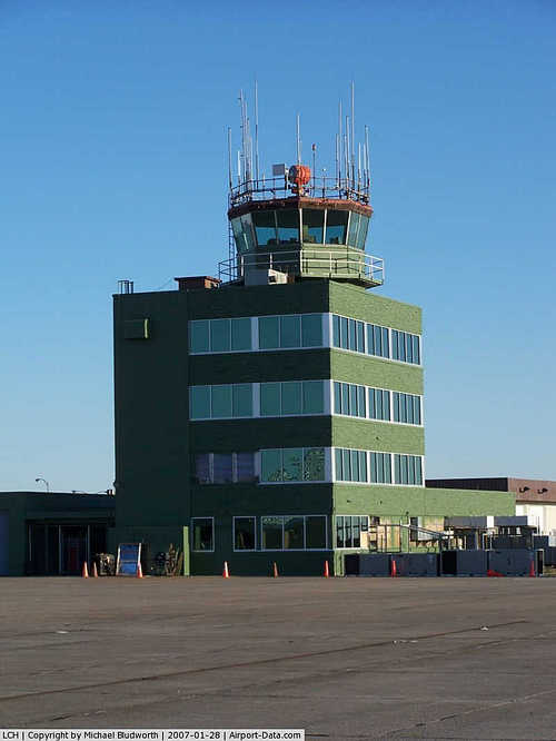
Airport Operations and Facilities
|
Airport
Use: |
Open to public |
|
Wind
indicator: |
Yes |
|
Segmented Circle: |
Yes |
|
Control
Tower: |
Yes |
|
Lighting
Schedule: |
DUSK-DAWN
WHEN ATCT CLSD ACTVT MALSR RY 15; ODALS RY 33; HIRL RY 15/33 & VASI RY
33 - CTAF.
MIRL RY
05/23 & VASI RY 23 OFF WHEN ATCT CLSD. |
|
Beacon
Color: |
Clear-Green (lighted land airport) |
|
Landing
fee charge: |
No |
|
Sectional chart: |
Houston |
|
Region: |
ASW - Southwest |
|
Boundary
ARTCC: |
ZHU - Houston |
|
Tie-in
FSS: |
DRI - De Ridder |
|
FSS Toll
Free: |
1-800-WX-BRIEF |
|
NOTAMs
Facility: |
LCH (NOTAM-d service avaliable) |
|
Certification type/date: |
I A S 05/1973
PPR 8 HRS FOR UNSKED ACR OPNS; ARFF INDEX B SVC AVBL ON REQ 0800-1630
MON-FRI EXCEPT HOLS CALL AMGR 337-477-6051-EXT 0. ARFF INDEX A AVBL
DURG ACR OPNS. |
|
Federal Agreements: |
NGY |
Airport Communications
|
CTAF: |
120.700 |
|
Unicom: |
122.950 |
Airport Services
|
Fuel
available: |
100LLA1+ |
|
Airframe
Repair: |
MAJOR |
|
Power
Plant Repair: |
MAJOR |
|
Bottled
Oxygen: |
NONE |
|
Bulk
Oxygen: |
NONE |
|
Runway Information
Runway 05/23
|
Dimension: |
5200 x 100 ft / 1585.0 x 30.5 m |
|
Surface: |
ASPH, Good Condition |
|
Weight Limit: |
Single wheel: 70000 lbs.
Dual wheel: 90000 lbs.
Dual tandem wheel: 140000 lbs. |
|
Edge Lights: |
Medium |
|
|
Runway 05
|
Runway 23
|
|
Longitude: |
093-13-47.0809W |
093-13-00.4770W |
|
Latitude: |
30-07-42.5986N |
30-08-14.3564N |
|
Elevation: |
10.00 ft |
14.00 ft |
|
Alignment: |
52 |
127 |
|
Traffic
Pattern: |
Left |
Right |
|
Markings: |
Non-precision instrument, Fair Condition |
Non-precision instrument, Fair Condition |
|
Crossing
Height: |
48.00 ft |
47.00 ft |
|
VASI: |
4-light PAPI on left side |
4-box on left side |
|
Visual
Glide Angle: |
3.00° |
3.00° |
|
Runway End
Identifier: |
Yes |
Yes |
|
Obstruction: |
65 ft tree, 1620.0 ft from runway, 455 ft right of
centerline, 21:1 slope to clear |
, 50:1 slope to clear |
|
Decleard
distances: |
Take off run available 5200.00 ft
Take off distance available 5200.00 ft
Actual stop distance available 5200.00 ft
Landing distance available 5200.00 ft |
Take off run available 5200.00 ft
Take off distance available 5200.00 ft
Actual stop distance available 5200.00 ft
Landing distance available 5200.00 ft |
|
Runway 15/33
|
Dimension: |
6500 x 150 ft / 1981.2 x 45.7 m |
|
Surface: |
CONC, Good Condition |
|
Surface
Treatment: |
Saw-cut or plastic Grooved
SOUTH 900 FT GRVD. |
|
Weight Limit: |
Single wheel: 100000 lbs.
Dual wheel: 145000 lbs.
Dual tandem wheel: 260000 lbs. |
|
Edge Lights: |
High |
|
|
Runway 15
|
Runway 33
|
|
Longitude: |
093-13-40.5139W |
093-13-08.8749W |
|
Latitude: |
30-07-43.3955N |
30-06-45.2289N |
|
Elevation: |
11.00 ft |
10.00 ft |
|
Alignment: |
127 |
127 |
|
ILS Type: |
ILS/DME |
|
|
Traffic
Pattern: |
Right |
Left |
|
Markings: |
Precision instrument, Good Condition |
Precision instrument, Good Condition |
|
Crossing
Height: |
54.00 ft |
50.00 ft |
|
VASI: |
4-light PAPI on left side |
4-box on left side |
|
Visual
Glide Angle: |
3.00° |
3.00° |
|
RVR
Equipment: |
midfield |
|
|
Approach
lights: |
MALSR |
ODALS |
|
Obstruction: |
28 ft pole, 1412.0 ft from runway, 421 ft left of
centerline, 46:1 slope to clear |
, 50:1 slope to clear |
|
Decleard
distances: |
Take off run available 6500.00 ft
Take off distance available 6500.00 ft
Actual stop distance available 6500.00 ft
Landing distance available 6500.00 ft |
Take off run available 6500.00 ft
Take off distance available 6500.00 ft
Actual stop distance available 6500.00 ft
Landing distance available 6500.00 ft |
|
Radio Navigation Aids
|
ID |
Type |
Name |
Ch |
Freq |
Var |
Dist |
|
UX |
NDB |
Sulfy |
|
278.00 |
04E |
11.1 nm |
|
DQU |
NDB |
De Quincy |
|
410.00 |
05E |
22.5 nm |
|
ORG |
NDB |
Orange |
|
211.00 |
05E |
29.9 nm |
|
DR |
NDB |
Idder |
|
385.00 |
04E |
38.1 nm |
|
LRR |
NDB |
Allen Parish |
|
379.00 |
03E |
41.5 nm |
|
ECY |
NDB |
Eunice |
|
263.00 |
02E |
47.9 nm |
|
BPT |
VOR/DME |
Beaumont |
092X |
114.50 |
07E |
42.6 nm |
|
SBI |
VOR/DME |
Sabine Pass |
101X |
115.40 |
07E |
50.0 nm |
|
LCH |
VORTAC |
Lake Charles |
081X |
113.40 |
07E |
6.2 nm |
Remarks
-
ATCT BLIND SPOT
ON TWY J.
-
BIRDS ON & INVOF ARPT.
-
USE EXTREME CARE
CONST ON TERMINAL RAMP.
Based Aircraft
|
Aircraft based
on field: |
202 |
|
Single Engine
Airplanes: |
38 |
|
Multi Engine
Airplanes: |
17 |
|
Jet Engine
Airplanes: |
2 |
|
Helicopters: |
145 |
Major Carriers Serving
This Airport
|
Expressjet Airlines Inc. |
100.0% |
Most Popular
Destinations
|
George Bush Intercontinental/houston (IAH) |
100.0% |
Most Popular Aircraft
|
N17521 |
2.8% |
|
N15527 |
2.8% |
|
N11526 |
2.5% |
|
N16520 |
2.3% |
|
N17513 |
2.3% |
|
N14516 |
2.3% |
|
N28529 |
2.0% |
|
N12530 |
2.0% |
|
N29515 |
1.7% |
|
N12540 |
1.7% |
Operational Statistics
Time Period: 2007-01-01 - 2007-12-31
|
Aircraft
Operations: |
114/Day |
|
Commerical: |
0.1% |
|
Air Taxi: |
32.7% |
|
General
Aviation Local: |
26.6% |
|
General
Aviation Itinerant: |
22.0% |
|
Military: |
18.7% |
Lake Charles Regional Airport
Address:
Calcasieu Parish, LA
Tel:
337-477-6051
Images
and information placed above are from
http://www.airport-data.com/airport/LCH/
We
thank them for the data!
|
General Info |
| Country |
United
States |
| State |
LOUISIANA |
| FAA ID |
LCH
|
| Latitude |
30-07-33.951N |
|
Longitude |
093-13-24.253W |
|
Elevation |
15 feet
|
| Near
City |
LAKE
CHARLES |
We don't guarantee the information is fresh and accurate. The data may
be wrong or outdated.
For more up-to-date information please refer to other sources.
|
|


